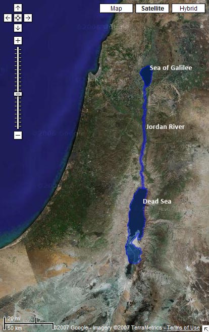
Download a KML with shapes for the Sea of Galilee, the Jordan River, and the Salt (Dead) Sea.
Preview it in Google Maps:
Limitations
The problem with water data is that water levels and paths fluctuate over time. The path in the KML for the Jordan River matches the current satellite data in Google Earth precisely, for example. But the river will change locations the next time Google updates its satellite imagery. And then I’ll either have to update the path to match the new imagery or live with the discrepancy. Of course, the current path of the Jordan only approximates the path it took in biblical times. So even if I update the file whenever Google gets new data, it still won’t accurately represent the historical context (which is impossible to reconstruct).
Even worse is the Dead Sea, which has dramatically shrunk over the past century as more fresh water gets diverted for human consumption. I tried to reconstruct the boundaries of the Dead Sea as it existed during the Bible, but the result is a disconnect between the satellite imagery and the shape file.
How I Made It
I made these outlines by tracing the satellite imagery in Google Earth using the Path and Polygon tools. It’s time-consuming, but you end up with a nice, accurate result. I’m surprised that no one’s done it before for some of these water bodies—at least, not that I could find.
Future Directions
I haven’t yet integrated the data with the rest of the KMLs because I’m not sure the best way to go about it. The main problem is that Google Earth doesn’t let you directly label a polygon or a path on the map. So while you can see the outline for the Sea of Galilee, you can’t know that that’s what it is. People often get around this limitation by creating a placemark inside a shape; I may end up doing that.
I hope to trace more bodies of water over time; I’ll be sure to blog about it when I do. This file represents my first attempts at creating polygons and paths in Google Earth. I wanted to try out some of the features I haven’t used yet. Reducing places to points on a map doesn’t always isn’t always the best way to represent them—some places cover large geographical areas, and shapes are useful in such situations.
