One Hundred German Aerial Photographs of Palestine (1925)
Gustaf Dalman
One Hundred German Aerial Photographs of Palestine
C. Bertelsmann · Gütersloh
Publications of the German Palestine Institute
Edited by G. Dalman
Volume 2
One Hundred German Aerial Photographs of Palestine
Selected and explained by
D. Dr. D. Gustaf Dalman
Director of the German Palestine Institute, 1902–1917; Professor at Greifswald
With a catalog of the Palestinian photographic holdings of the Bavarian War Archive by Father Dr. A. E. Mader, S.D.S.; a report on Flying Detachment No. 304 by State Archivist Baron von Waldenfels; and a map of Palestine by cartographer W. Goering.
Printed and published by C. Bertelsmann in Gütersloh · 1925
Foreword to this 2026 Digital Edition
This digital edition presents Gustaf Dalman’s 1925 volume of Palestinian aerial photographs as a readable, linked English edition. The printed book combines 101 images, German captions and commentary, a fold-out overview map, and a large back-of-book catalog of photographs held by the Bavarian War Archive. This project combines these pieces into a single experience.
The English text is a new AI-generated translation from the printed German. The aim is not to modernize Dalman’s work, but to make the book usable while preserving its historical vocabulary, ordering, and claims. Place names therefore follow a readable English transliteration where that helps the reader, while older forms and specific printed identifications are retained when they matter to the source. Some “Germanisms” remain in the text; Arabic transliterations, especially, arrive in English by way of German.
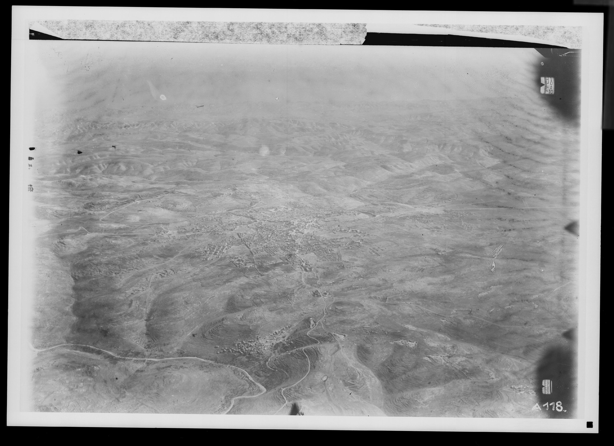
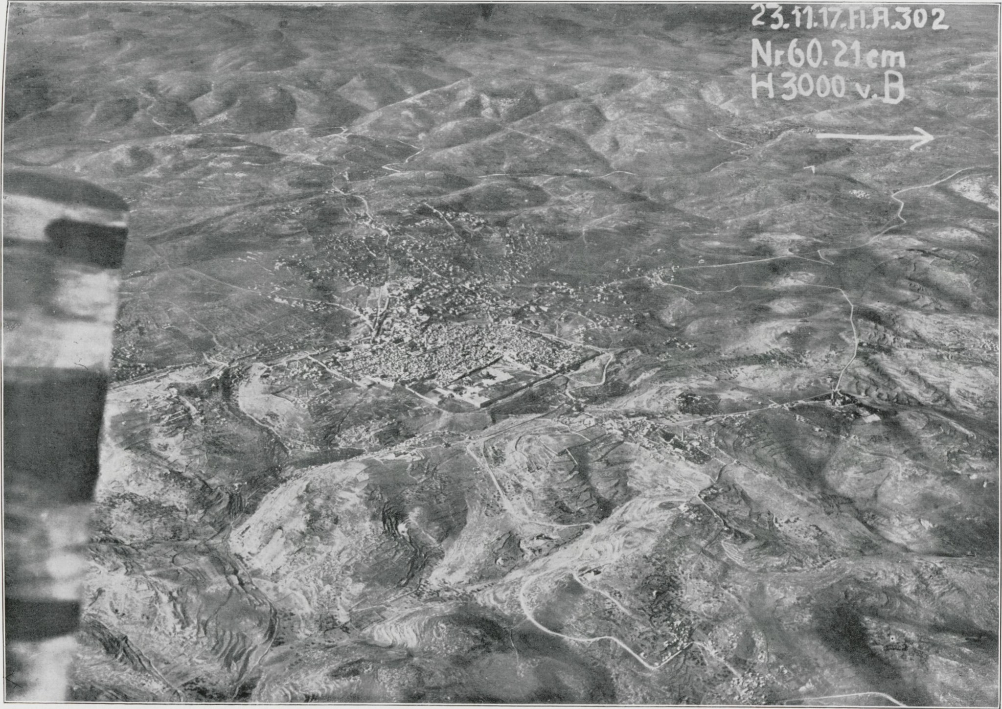
The plate images shown first are restored versions prepared for easier reading. Click or tap an image to compare it with the original scan from the printed book; the restored image is meant as a reading aid, while the original remains available for checking detail, tone, and artifacts.
Many image descriptions also mention a grid, with references such as 13–15c pointing to areas inside the image itself. Where those regions have been marked in this edition, the Show regions button overlays approximate soft outlines on the image, and linked grid references in the text can be clicked or hovered to isolate the corresponding area. These regions are guides to understanding the image, not exact object boundaries.
Back Material
The catalog reproduces the two printed back-of-book tables: the aerial Verzeichnis der Palästina-Flieger-Aufnahmen des Bayerischen Kriegsarchivs and the Bodenaufnahmen (ground-photograph) table. They were transcribed from the printed catalog. Columns: LN (laufende Nummer, the running catalog number); FN (Fliegernummer, the per-photograph serial that matches the “No.” printed on each plate); KQ (Kartenquadrat, the map-grid reference into the fold-out overview map); Date (Zeit, date and/or time of the photograph); Alt. (Höhe, flight altitude in metres); Focal (Brennweite, lens focal length in cm). The Archive Records column links to the matching Bavarian War Archive records.
The printed section headings, subsection headings, and occasional inline notes are kept in their original order. The ditto mark (〃, “same as the row above”) in the original is instead shown as the repeated value rather than the mark, so each row can be read on its own. Dates are normalized for legibility (“8 Sep 1918, 2:30”). The book records times on a bare 12-hour clock with no morning/afternoon marker, so they are shown exactly as printed; where the book gives only an approximate time of day, words such as vormittags and nachmittags are translated as “morning” and “afternoon.”
The Archive Records column links each entry to its matching record or records in the Bavarian State Archives (Bayerisches Hauptstaatsarchiv) through the GDA viewer.
The Map grid column is the photograph’s Kartenquadrat (KQ), its square on the reporting grid of the German 1:50,000 military map of Palestine. Each KQ number links to the location on Google Maps.
Those coordinates are editorial additions, not part of the book. The reporting grid is roughly a one-kilometre grid, but its labels repeat every 100 km, so a bare grid reference is ambiguous on its own. Each photograph’s square was resolved from the catalog’s geographic ordering and known reference towns, then converted to latitude and longitude. The result is accurate to about a kilometre: good enough to find the place, not a survey fix.
Some rows print no grid reference at all, including Sidon, Tyre, the Jerusalem overviews, and subjects well outside the mapped area such as Cairo, the Suez Canal, Baalbek, Damascus, and Ma’an. Where the caption names a recognizable place, an approximate location is shown with a leading ≈; this is a caption-based estimate rather than a position derived from the map grid. Two captions too vague to place are left without coordinates.
Where a catalog entry is one of the photographs reproduced in the book, its catalog number links to that plate. A companion distribution map plots every located photograph by section, distinguishing grid-derived positions from the caption-based estimates.
Historical Context
The original German book is available from the University Library Tübingen’s OpenDigi scan.
Tin Gustaf, a collection of 14,000 photos from the Dalman collection.
About the Use of AI in this Project
AI wrote this Foreword (with human edits). It generated the images. It did the translations. It wrote the HTML, CSS, and Javascript. This project would not have been possible without AI.
The original black-and-white images bear close inspection. The AI-generated images, created by GPT-Image-2, fall apart if you look at them too closely.
Copyright
This book dates from 1925, and the photos date from 1917 and 1918. They are out of copyright in the United States. This book is in the public domain.
AI-generated images are not copyrightable in the United States. The images in this project, its translation, and any other modern contributions (such as this Foreword) are published under a CC0 license. They are also in the public domain.
Preface
Since the sixth-century Madaba Mosaic, with its depiction of Palestine, the Egyptian desert, and the Nile Delta, the representation of the Holy Land has had a varied history.
Only with the invention of the woodcut toward the end of the fifteenth century did an era begin in which attempts were made to use at home, for purposes of illustration, what had been observed and drawn in Palestine.
But when the awkward pictures of Bernhard von Breydenbach (1483) and the more skillful drawings of Jean Zuallart (1586) are compared with reality, one sees that they never reproduce landscapes actually observed. Instead, as the Madaba Mosaic had essentially already done, they attempt to convey, from an oblique bird’s-eye view, an impression of the appearance, location, and relative positions of the places depicted.
The pilgrims do not appear to have possessed, as material for their pictures, anything more than inadequate sketches of a few buildings and places. Only with the Dutchman Cornelius de Bruyn and the engravings in the account of his travels published in 1698 do carefully executed drawings of things actually seen begin to reveal a closer relationship to Palestinian reality; they may therefore be described as views from ground level.
Yet even here one wonders how the draftsman could place the otherwise quite accurately rendered Bethlehem behind a plain and link Jerusalem with the Hill of Samuel in a way he cannot actually have seen. Later, Romanticism considered itself entitled to rearrange what had been observed according to aesthetic principles and adapt it to the taste of the time.
Thus arose the romantic fantasy pictures of Luigi Mayer, Clark, Harper, and Roberts, among whom Bernatz stands out for his greater sobriety. Luigi Mayer (1810–14), whose work was introduced by none other than the Orientalist E. F. K. Rosenmüller, even suffered the misfortune that—probably because of an error in reproduction—a number of the pictures appeared reversed from right to left without the editor noticing.
Pictures of so fanciful a kind have continued into the present day to play an undeserved role, even in editions of the Bible, although photography had begun, in the final third of the previous century, ruthlessly to destroy the aura of romantically embellished landscape pictures through its unvarnished views taken on the ground.
The Bonfils firm in Beirut, among others, deserves credit for having photographed Palestinian places and landscapes extensively some fifty years ago; and the oldest photographs of theirs in our possession are especially valuable because they show us the towns and their surroundings still undistorted by the powerful Europeanization that has taken place since then.
In outward appearance, present-day Nazareth is now a small town almost in the Italian style, wholly unlike the image of Nazareth around 1870 that lies before me in two large photographs—so unlike it that I found it difficult to identify the details, although I had already visited Nazareth twice in 1899.
All the collections of photographs of Palestine available to us are imperfect, however, in that they often identify neither the subject precisely, nor the direction from which it was photographed, nor even the exact time when the photograph was taken, though this is important to the character of the landscape in many respects. Moreover, they suffer from a one-sided focus on holy places and historical sites, while providing no information about their general setting—which is what is truly authentic and reliable about them—and leaving unrepresented the nature of the country, with which its entire history is connected.
Unfortunately, the professional photographers working in Palestine, from whom we would chiefly expect good landscape photographs, are themselves far too dependent on what tourists without geographical or historical training wish to buy as souvenirs, while the needs of the country’s history and geography remain unmet and cannot be satisfied by pictures of a few “antiquities” either.
Here, then, this collection of images seeks to represent an advance. With the aerial photographs, both oblique and vertical, we return at the same time to the visual conception of Palestine that the Madaba mosaic and the unromantic depictions of the fifteenth and sixteenth centuries sought to convey. But in place of an artificially assembled picture, the aerial photographs set reality as seen from above: the locality together with its surroundings, the external conditions of its existence, its means of communication, and its actual lines of communication down to the present day.
It is certain that the aerial photographs need to be supplemented by ground photographs, which assist our powers of imagination and provide a better impression of the elevations. Yet it is only through the aerial photographs that the ground photographs are placed within the landscape from which they originate.
Several ground photographs taken by our airmen, such as those reproduced here of the Jezreel Plain, also show that such photographs could and should convey the appearance of large regions far more extensively than they have until now. What can be seen on every side in Palestine from the Mount of Olives, from el-Muntar, from Sherifet en-Nebi Danjan, from Ebal, and from Nebi Sa‘in above Nazareth ought to be recorded in good panoramas. These would be more important than the existing panoramas of present-day Nazareth or Jerusalem, provided they were accompanied by precise descriptions.
The fact that many aerial photographs afford no aesthetic pleasure—although among the oblique views there are some that may rightly be called beautiful—does nothing to diminish their value. They compel the viewer either to immerse himself in them and learn geography and history from them, or to pass them by. The time will come, however, when we shall already have become accustomed at school to such teaching material, and when flying ourselves will give us the opportunity not merely to see landscapes from above but to learn to understand them. It is this understanding that most of us lack, at home as much as abroad.
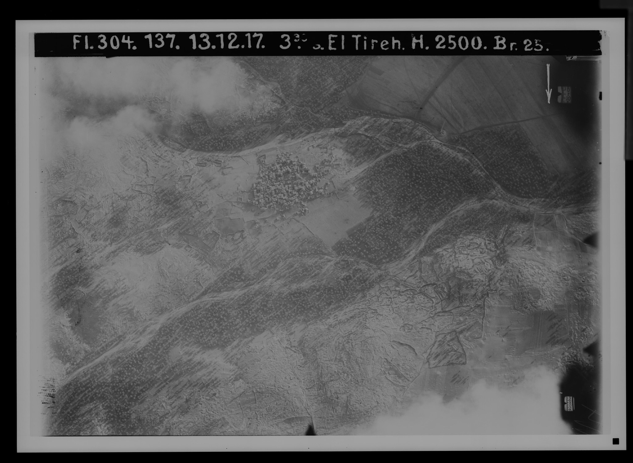
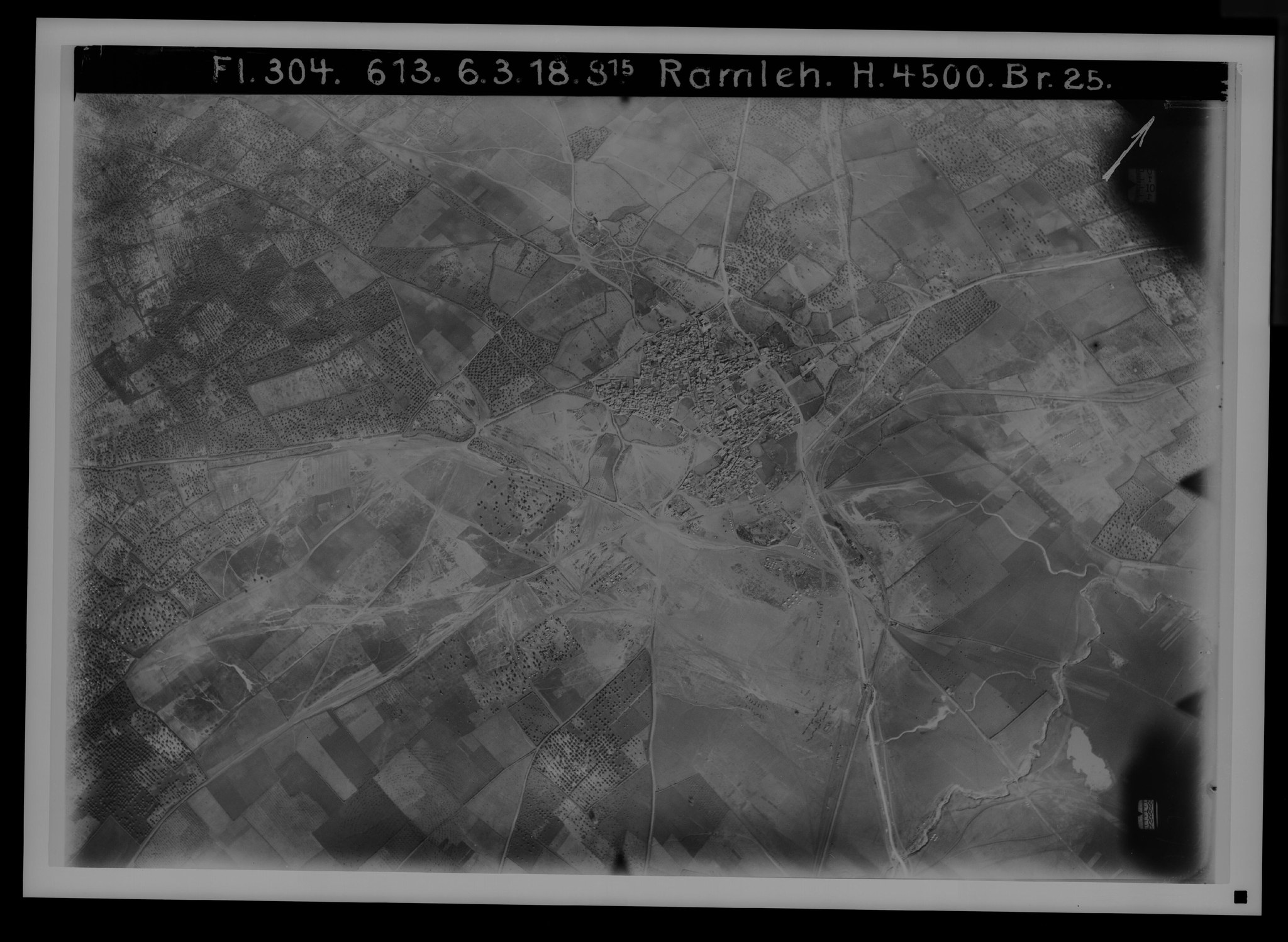
The reconnaissance work of German Flying Detachments 300 to 304 in the years 1917 and 1918, through photographs taken not only for military purposes, ushered in a new era for the visual study and cartography of Palestine. A selection of such images, almost all of which are owed to Bavarian Flying Detachment No. 304, is presented here with the kind permission of the Bavarian War Archive and—for the images originating from other sources—of the German Reich Archive.
If they are to fulfill their purpose, they should not merely be looked at but studied in detail. They have therefore been supplied with explanations whose numbers and letters refer to squares that, when the accompanying grid is laid over the image, make it possible to locate the named place in the picture. The grid is to be positioned so that its corner marked “upper left” lies over the upper-left corner of the image.
To remove any doubt about compass direction, the photographer’s position relative to the landscape is indicated in the usual manner for ground photographs. For oblique and vertical photographs, the text gives the compass direction of the lower edge of the image. The arrow appearing on many images does not always correspond to true north. In the book, the images have almost always been oriented so that the light falls from above or from the left, since only in this way do the details acquire the proper relief for the eye. Consequently, in oblique photographs the more distant ground may appear in front—that is, at the bottom of the image. No consideration was given to north when orienting the images.
When viewing the images, it should above all be borne in mind that in vertical photographs elevations as such disappear and become recognizable only through their shadows, when the position of the sun and the direction of the slopes stand in the corresponding relation.
Towers, too, are recognizable only by their shadows. In the oblique photographs, what matters is that the shadows lie in the direction of the photograph and therefore become visible in the image. For the rest, reference is made to the important advice and information given by Dr. Mader in his “Introduction”; it should be read before the images are examined.
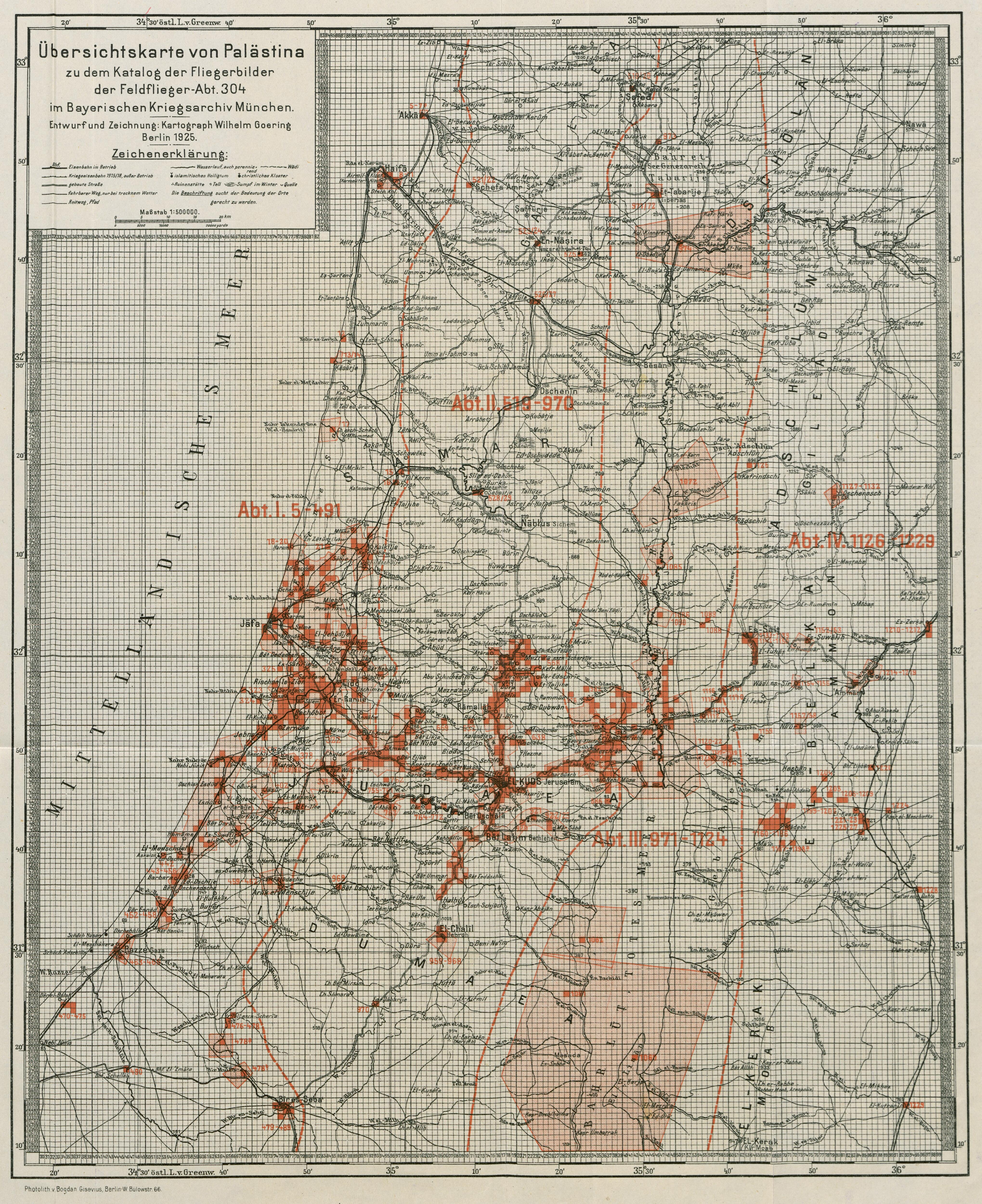
The map of Palestine prepared by cartographer W. Goering from the latest material also deserves particular attention.
All images for which the numbers in Dr. Mader’s catalog are given with “V.” come from the Bavarian War Archive. Photographs marked “RA.” come from the holdings of the Reich Archive. Images lacking either designation come from private collections but were published with the permission of the Reich Archive.
The selection has been made so as to present the most important features of the various parts of Palestine. Anyone wishing to study other subjects or more precise details should apply for photographic prints to the Photographic Department of the Bavarian War Archive, Munich, Lothstraße 17. No catalog of the photographic holdings of the German Reich Archive in Potsdam has yet been published. But I hope that this too will yet be done in conjunction with a supplementary collection of pictures. In anticipation of it, I have excluded from this collection all material relating to Philistia and the south; it will, however, also add significant material from other regions.
Many valuable photographs are still in private hands, their plates being absent from the official archives as a result of the rapid retreat. A catalog of these too should be compiled, stating where copies may be obtained, so that they do not remain withheld from scholarship. It is also important for a knowledgeable person to establish their correct designations, since serious errors occur. Hebron has been published as Bethlehem, the Barada River near Damascus as the Yarmuk, the Dead Sea as the Sea of Tiberias, and the Mount of Olives as a part of Bethlehem. Even in the 1921 yearbook of the League of Asia Combatants, the well-known waterfall of the Yarmuk is said to originate in “the source region of the Jordan.” The undersigned will be grateful if photographs of Palestine and Syria are made accessible to him for this purpose.
A great deal of time and effort was devoted to identifying the details in the pictures precisely, with the aid of other aerial photographs and other images, the best available map material, notes, and personal knowledge of the localities. Errors may nevertheless have occurred. Anyone who notices any is requested to inform me so that they may be corrected when the planned “Supplement” is issued.
Users of this book are kindly asked to excuse the fact that Arabic place names are transcribed according to different principles in the appendices and in my own text.
Abbreviations
V. — number in Dr. Mader’s catalog
RA. — Reich Archive
FA — Flying Detachment
Kh. — khirbet (ruin, settlement site)
PJB — Palästinajahrbuch of the German Protestant Institute for the Archaeology of the Holy Land
Jerusalem, German Parsonage, P.O.B. 327, 3 March 1925. Home address: Greifswald, Arndtstraße 31.
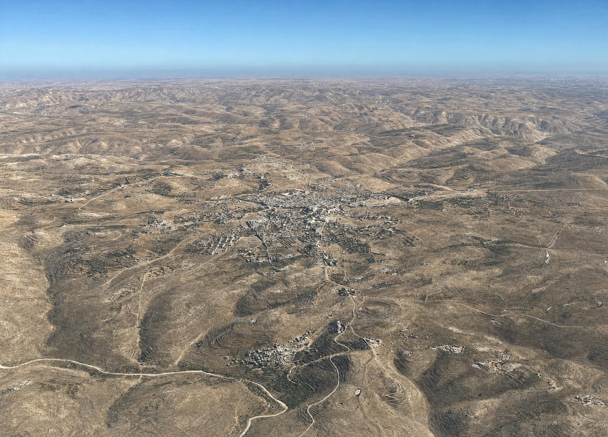
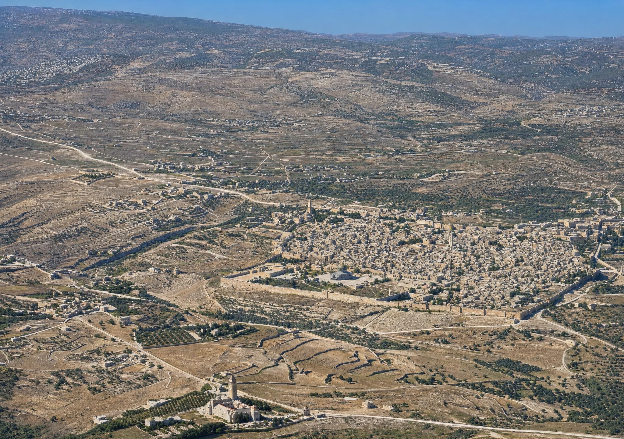
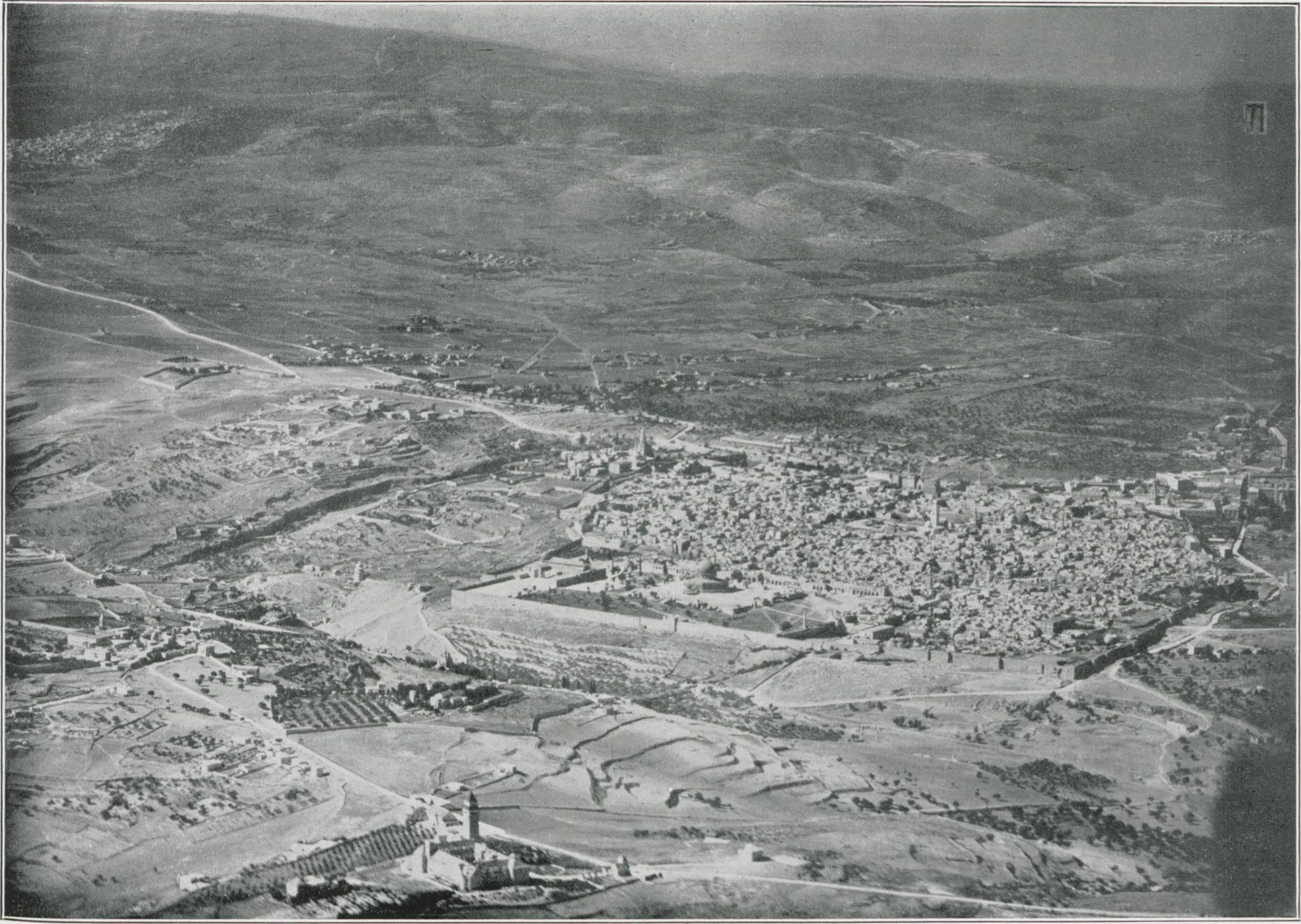
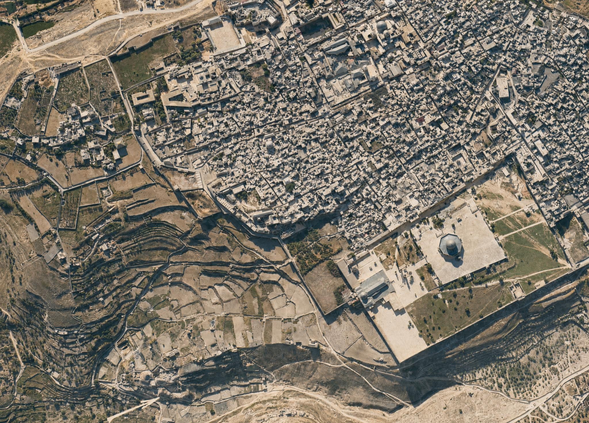
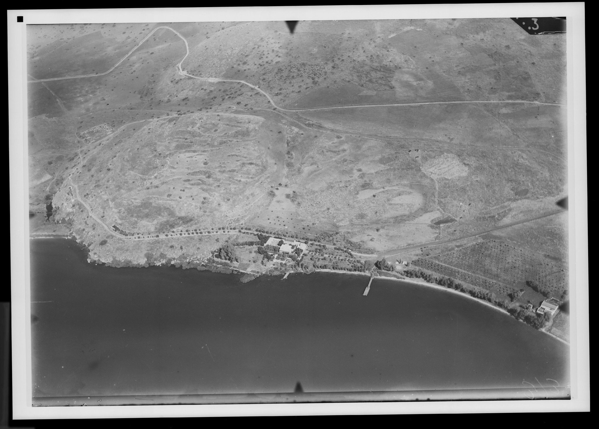
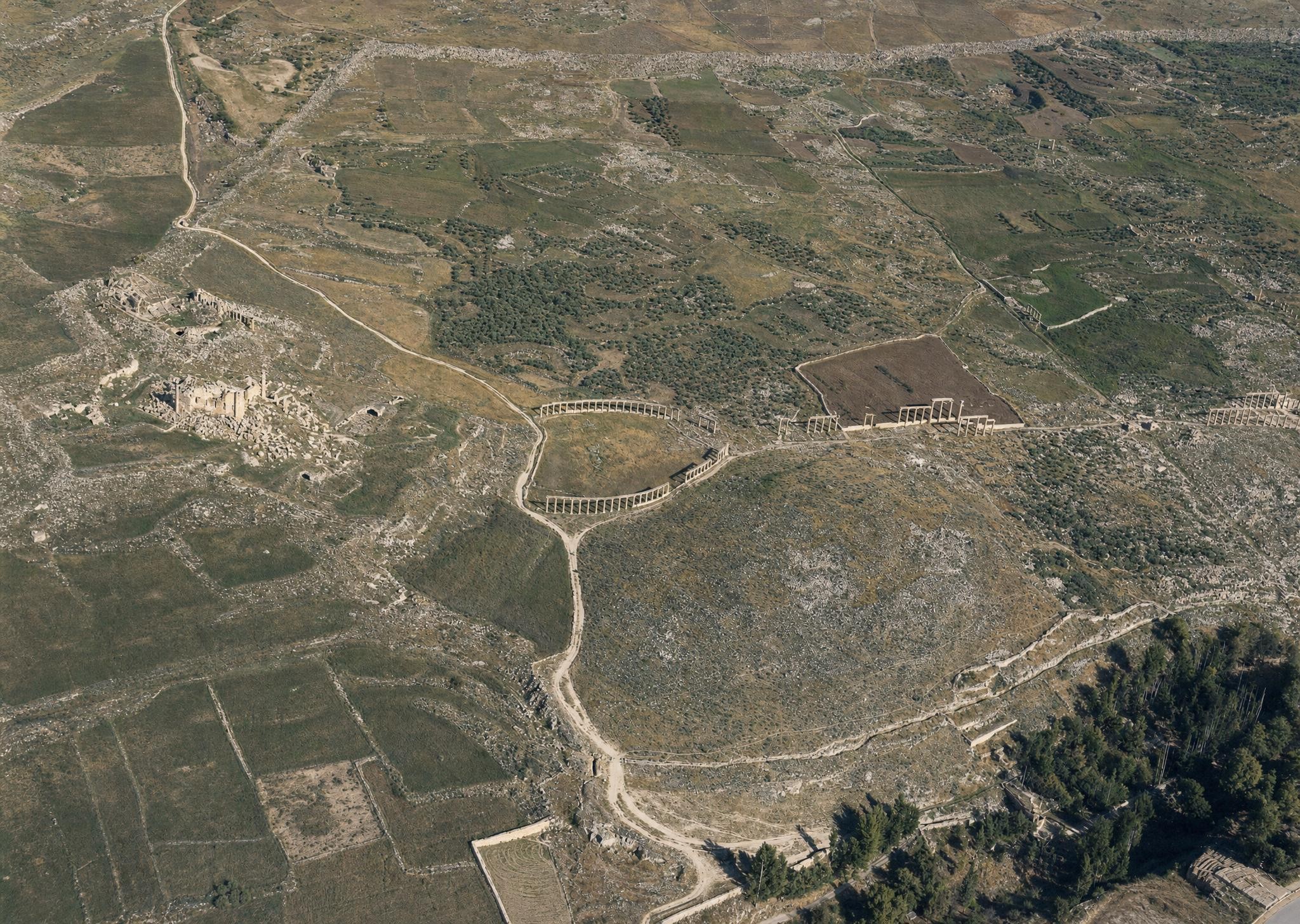
1. Jerusalem and its surroundings from the west-northwest. V. 775.
Plate 1. Jerusalem and its surroundings from the west-northwest.
FA 304, No. 18. 22 November 1917, 11 a.m.; altitude 2,500 m; focal length 25 cm.
Jerusalem lies in the center of the picture, its Temple Mount standing out as a bright surface in the midday sun. Because of the altitude from which the photograph was taken, it is not immediately apparent that the terrain beyond the city falls away and that the watershed between the Mediterranean and the Dead Sea runs across the landscape. Yet the valleys before the centerline of the picture descend toward the foreground, that is, westward, while those beyond it run toward the other side, showing that the land falls away there. The surface of the Dead Sea visible in the east lies 390 m below sea level. The highest visible points are the Mount of Olives (815 m) and, on this side of Jerusalem, the height along the Jaffa road (819 m); Jerusalem, descending to 740 m, therefore lies on a surface sloping eastward.
Of the valleys, the principal one is Wadi Lifta in the left foreground, conspicuous for its white channel. Wadi Umm el-‘Amad joins it from the watershed as an eastern tributary. The main valley's farther course, no longer visible here, receives all the other valleys in the lower-right half of the picture: first Wadi ‘Akbet el-Beda toward the foreground, then Wadi ‘En Rauwas to the right, and higher up Wadi Ka‘at el-Uzir. The plain of el-Bak‘a (the Valley of Rephaim, Josh. 15:8) also belongs to this western slope. All of it lies in the basin of Wadi es-Sarar, which drains into the Mediterranean.
Beyond the watershed, Wadi en-Nar, perhaps the Valley of Acacias (John 4:18; compare PJB 1909, p. 13), is the defining feature of Jerusalem's immediate surroundings. Its western tributary, Wadi er-Rababe (the Valley of Ben-Hinnom), appears as a deep channel south of Jerusalem. Wadi en-Nar can be followed first southeastward and then, after a sharp turn eastward, as far as Mar Saba. Wadi Abu Hindi crosses the mountainous desert from west to east and breaks through the mountain chain toward the Dead Sea at the left edge of the picture; Wadi es-Sikke runs parallel to it nearer the watershed. Farther down the descent toward the Dead Sea, the plain of el-Ibke‘a separates the Muntar range from the marginal mountains of the Dead Sea, which stand only about 200 m above Mediterranean sea level. The Dead Sea is visible from the region of ‘En Jidi (Engedi) in the south to its northern end, though the photograph's lack of sharpness makes it indistinguishable from the Jordan Valley. Beyond it rises the plateau of Moab, approximately from Mount Nebo in the north to the Arnon in the south.
Besides Jerusalem, its suburbs to the north, west, and south, and its outlying settlements to the south, the following places are visible. In the foreground is Lifta-Nephtoah (Josh. 15:9), perhaps once situated on the height between the two roads; its spring on the slope to the right of the village sends a small stream into the valley in spring. Deir Yasin is in the right corner. In the northeast, at upper left, is el-‘Isawije (Laisa, Isa. 10:30); et-Tur is on the Mount of Olives; farther east is el-‘Azarije (Bethany, Matt. 21:17; Ananiah, Neh. 11:32, according to Albright), with Abu Dis above it to the right. Sur Bahir is barely recognizable in the southeast. Also visible in the southwest, from left to right, are the Monastery of the Cross and the patriarchal residence at Katamon.
Important roads: From Jerusalem toward the foreground, northwestward, runs the western or Jaffa road. In front, its older southern line forms a switchback in Wadi ‘Akbet el-Beda; higher up, a southern branch leads to ‘En Karim. At left center is the northern or Nablus road, with a bend on the slope of Ras el-Mescharif (Mount Scopus), and above it the Mount of Olives road built in 1898. At the foot of the Mount of Olives, then curving around it twice to the right, is the eastern or Jericho road, which disappears into Wadi es-Sikke. On the right is the southern or Hebron road on this side of the watershed; before it, in Wadi Ka‘at el-Uzir, is the unmetalled southwestern road to Gaza.
The photograph presents a view approximately 30 km wide in the background, about 4 km wide in the foreground, and 40 km deep. It therefore shows a substantial section of the Judean hill country and its desert in a way that even a view from the Mount of Olives cannot. Only someone familiar with the terrain, however, would know that the Mount of Olives range rises rather than falls from the Mount of Olives toward the left edge of the picture.
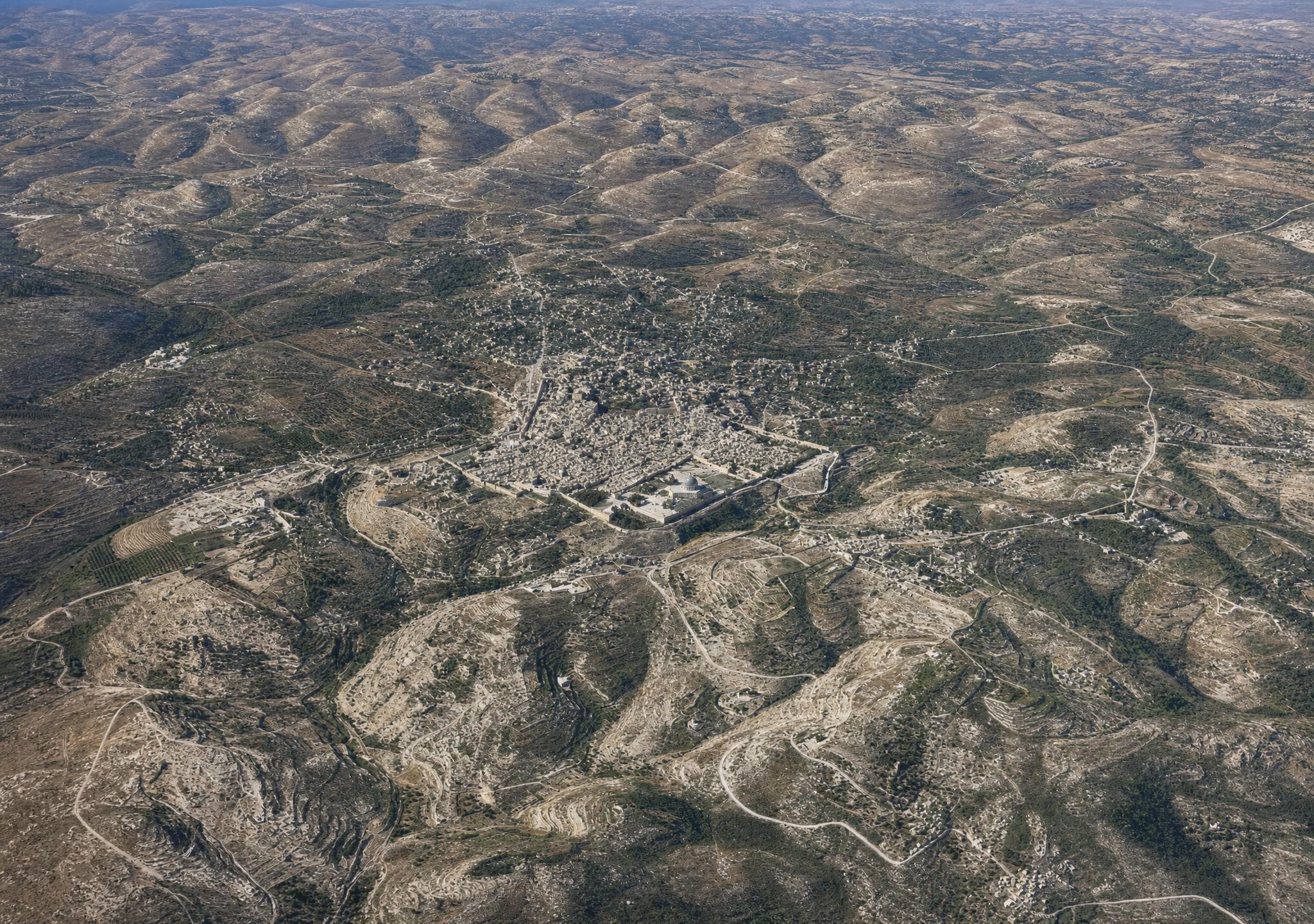
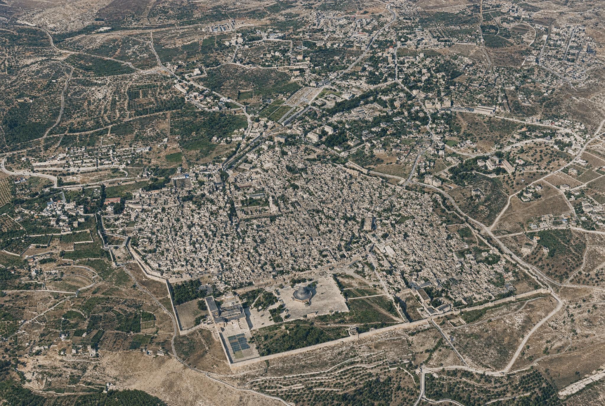
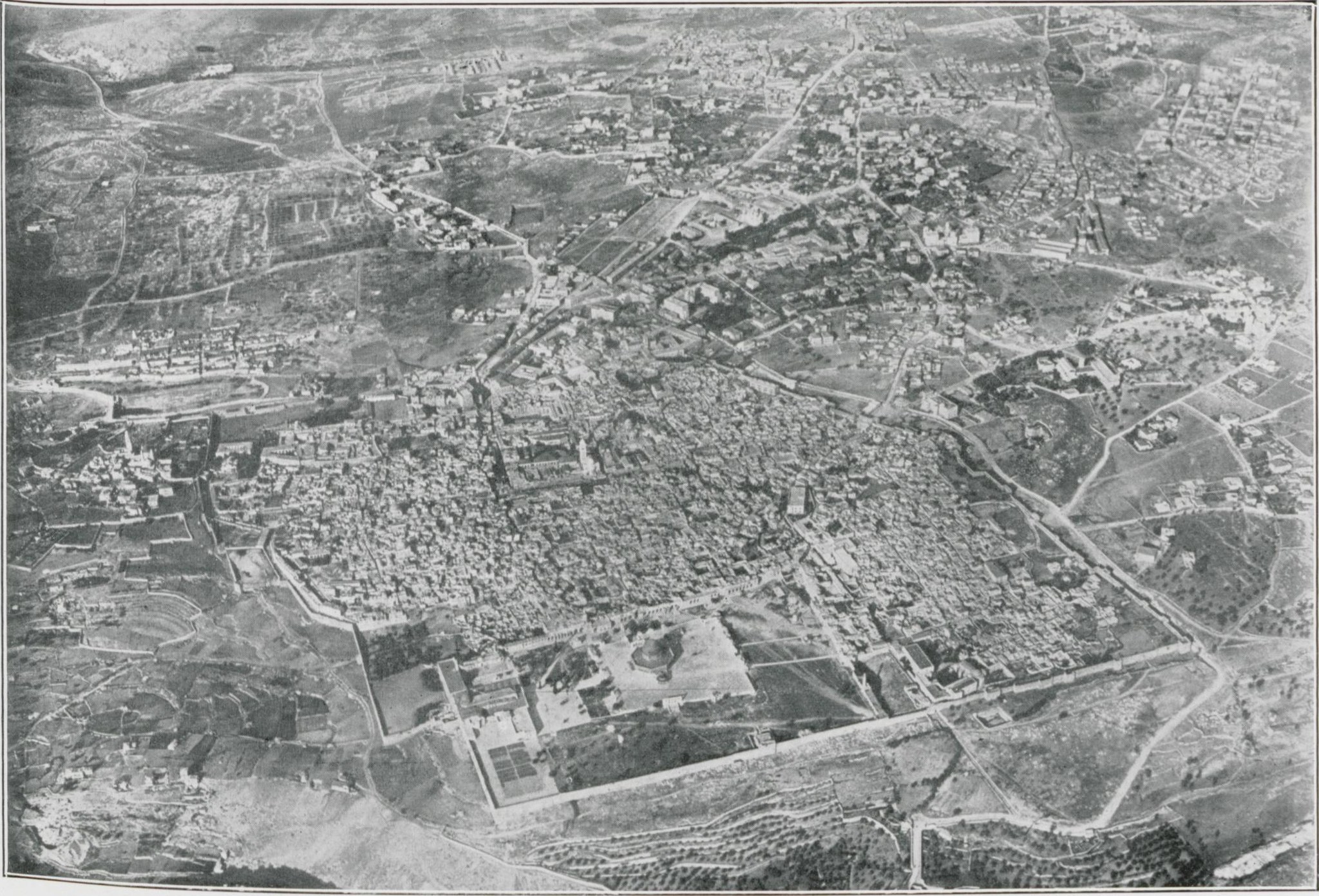
2. Jerusalem and its surroundings from the southeast.
Plate 2. Jerusalem and its surroundings from the southeast.
FA 302, No. 60. 23 November 1917, around noon; altitude 3,000 m; focal length 21 cm. Arrow points northeast.
In the foreground is the Mount of Olives range with its eastern slope. On the left it is bounded by Wadi en-Nar and its two upper branches: to the north, Wadi Silwan and Wadi es-Sitt Mirjam (the Kidron Valley); from the west, Wadi er-Rababe (the Valley of Ben-Hinnom, Josh. 15:8); in front, Wadi Kaddum, a northern tributary of Wadi en-Nar coming from the Mount of Olives; and on the left, Wadi Jasul coming from the watershed.
Beyond Jerusalem is the great valley system of Wadi Bet Hanina, or Wadi Lifta, formed by the two branches Wadi ed-Damm on the right and Wadi Duwed on the left, whose upper course can be followed beyond Rafat. Toward the foreground is its eastern tributary Wadi Umm el-‘Amed; farther to the right are the northern tributaries Wadi ‘Isa and Wadi Buwaj. In the upper background to the right are the valleys around Beit Ur el-Foka (Upper Beth-Horon), and to the left the valleys beyond Kiryat Abu Rosh (Kiriath-Jearim). They belong to the basin of Nahr el-‘Oja, whose watershed is formed by the heights from el-Kerje to Biddu.
The elevations on this side of Jerusalem appear in sequence: Baten el-Haua (727 m), et-Tur (the Mount of Olives, 815 m), Umm et-Tala‘ (818 m), el-Madbase, Ras Abu Halawi, Ras el-Mescharif (Mount Scopus, 779 m), and then the watershed heights as far as Tell el-Ful (840 m). Beyond Jerusalem to the west is the height of Deir Yasin, above it the height of Qastal (808 m), the heights near Kiryat Abu Rosh (763 m), and in the northwest the towering mountain of en-Nebi Samwil (895 m).
Jerusalem's position at the confluence of the Kidron and Ben-Hinnom valleys, the eastward slope of its surface, the southern spur of the Temple hill as an apparent eastern fore-terrace of the western hill, and the southern portions of the western and eastern city hills left outside Jerusalem since the Roman Aelia Capitolina are all clearly visible.
Other settlements: Silwan in the Kidron Valley; et-Tur and the Russian tower on the Mount of Olives; el-‘Azarije (Bethany) in two parts, the older western and younger eastern parts, on the eastern slope; el-‘Isawije (Laisa) east of Mount Scopus; Sho‘fat to the northwest; and Beit Hanina still farther northwest. Above the V in “V. B.” is Bir Nebala; by the r in “Nr.” is ed-Dschib (Gibeon), with en-Nebi Samwil on its height. Above Wadi ‘Isa is Beit Iksa; beyond Wadi Buwaj is Beit Surik, shown dark, with Biddu on the height opposite it. Lifta is hidden behind its height, but above the valley on the far slope is Qalunya, with Deir Yasin on the near side; Qastal is barely recognizable on its height, Beit Nakuba lies farther west, and Kiryat Abu Rosh (Kiriath-Jearim) is in shadow. The Monastery of the Cross, the Templer Colony, and the houses of Deir Abu Tor lie southwest and south of Jerusalem.
In the foreground, the carriage road to Jericho circles south of the principal summit of the Mount of Olives; a shortcut crosses the height above Bethany.
Historically important routes across the Mount of Olives range are: first, a route over the Mount of Olives, passing north of Bethany to the Jericho road; second, a route farther north over the Mount of Olives through Wadi el-Lehham to the Jericho road; and third, the Roman road from the northeastern corner of the city past Umm et-Tala‘, likewise toward Jericho.
The modern road to the Mount of Olives partly follows an old connection to the northern road, which can be traced as far as Ras Abu Halawi. The northern road, with its bends across Wadi ed-Dschoz and on the slope of Ras el-Mescharif, is visible as far as its western fork, the Beth-Horon road, near Tell el-Ful (Gibeah of Saul). The branch of the road toward Jeba‘ is also recognizable; see PJB 1916, p. 54.
The western road shows the southern branch toward ‘En Karim and the older southern secondary line mentioned under No. 1. Beyond Qalunya it climbs, with a bend, to the Qastal pass; farther on, the section from Wadi Ekbala to Kiryat Abu Rosh is visible. The southwestern road to Gaza can be followed, with its branch toward ‘En Karim, as far as the vicinity of the Monastery of the Cross. The southern road is visible only as far as the Templer Colony because an airplane wing conceals the remainder.
The photograph spans about 15 km across the background and surveys a distance of about 18 km: the entire Judean ridge around Jerusalem as far as the beginning of the western descent toward the hill country, the Shephelah, and the coastal plain.
3. Jerusalem from the northeast. V. 776. Reichsarchiv.
Plate 3. Jerusalem from the northeast.
FA 300, No. 1334. Photograph taken at about 9 a.m.; deepest shadow to the north.
The view surveys Jerusalem in relation to its eastern valley, the Kidron, its southern valley, Ben-Hinnom, and its southwestern surroundings. In the left foreground is the Mount of Olives with the Ascension shrine (); to the right is the Mount of Olives road, beside it the turreted hospice of the Empress Augusta Victoria Foundation (). Beyond the Kidron Valley is the walled Old City with the Temple Mount (), the Church of the Redeemer (), the Church of the Holy Sepulchre (), the Tower of David (), the Franciscan monastery and Christian Brothers' building (), and the French hospice (). To the south are the Church of the Dormition () and Nebi Daud (); beyond them to the west is the Jewish colony (), and to the south the houses of Jebel Deir Abu Tor (). In the nearer background is the plain of el-Bak‘a, the Valley of Rephaim, draining through the valley of Bettir () toward the Mediterranean.
The watershed hills separating the plain from the vicinity of Jerusalem appear low in the west, while the mountains in the background appear enormous. They rise first along the Kremzan ridge () to 900 m, then near Sherifet en-Nebi Danjan () to 994 m. Behind them is the western slope of the Judean hill country.
Settlements: on the height, Beit Jala () opposite Bethlehem; beside the plain to the south, Beit Safafa () and Sharafat (); to the north, el-Malha (), with Bettir probably above it ().
Roads: southward, the Hebron road (), whose continuation appears again near Sherifet en-Nebi Danjan (); in the Kidron Valley, the Jericho road () and the Roman road to Jericho (). For the railway line () in the Valley of Rephaim, compare Nos. 7 and 8.
4. Jerusalem and its suburbs. View toward the east-southeast. V. 779.
Plate 4. Jerusalem and its suburbs. View toward the east-southeast.
FA 303, No. 779. 2 November 1917, 8:45 a.m.; altitude 1,800 m.
In the center is the Old City with the Temple Mount, the white Church of the Redeemer (), the two domes of the Church of the Holy Sepulchre (, left), the Tower of David (), the Austrian Hospice () on the Via Dolorosa, the site of the Antonia Fortress (), St. Anne's Church, and the Pool of Bethesda ().
Outside the Old City to the south is the Church of the Dormition (); to the west is the Sultan's Pool (), with the Montefiore colony and the olive groves of en-Nikeforije above it.
In the west is the Jaffa Gate (). Radiating southwestward from it is the road to el-Malha (); branching westward from that is the road to ‘En Karim (), and northwestward is the road to Jaffa (). Between the Jaffa road and the Malha road is the Mamilla Pool (), and along the Jaffa road is the Jaffa suburb.
In the north is the Damascus Gate (). From there a connecting road leads to the Jaffa road (); the northern road passes the church of the Anglican bishop (), with connections from there to the northwestern corner of the city () and the southern road. Herod's Gate () has a connecting road to the northern road (). At the northeastern corner of the city is Burj Laklak (), with the road to Jericho ().
In the south is David's Gate, with a path to the Kidron Valley (). In the valley are the Virgin's Spring, Gihon (), and the Greek Chapel of St. Stephen ().
The elevation generally rises toward the northwest and west: the Temple Mount is about 740 m, and the Jaffa road at is 815 m. The valley to the west, containing the Sultan's Pool, and the ridge beyond it are not recognizable as such.
5. Old Jerusalem. View toward the southeast. V. 790.
Plate 5. Old Jerusalem. View toward the southeast.
Photograph taken in the afternoon, with shadows on the eastern slopes.
This vertical photograph gives a clear view into Jerusalem's street system, which is connected with the system of Roman Aelia on the Madaba mosaic. From the Damascus Gate (), a market street runs directly south across the city, ending at . A second street goes from the same place first southeastward, then turns south at and, after several bends, reaches the eastern south gate, Bab el-Magharibe (). Both lines are crossed by David Street, which runs from the Jaffa Gate () to the Temple platform (). Its line corresponded to the northern wall of the city of Jerusalem in Jesus' time. A second cross street begins at and joins the second longitudinal street at . One may then go northwest along this street for a short distance and turn east at the Austrian Hospice (), thus reaching St. Stephen's Gate ().
The Via Dolorosa begins on the last-mentioned line at the site of the Antonia Fortress (), continues along that section of the street from the Damascus Gate, and runs on the second cross street to , where it ends opposite the Church of the Holy Sepulchre as the site of Golgotha ().
The suburb in Jesus' time probably had its western wall along the line of the market street, and its northern wall roughly along the line of the Via Dolorosa. Outside it, then, remained the Church of the Holy Sepulchre, which in Constantine's time had its entrance from the market street, and the so-called Pool of Hezekiah (). The Greek market () is on the site of the Hospital of the Knights of St. John; east of it is the Church of the Redeemer ().
Beside the Jaffa Gate is the citadel () with the Tower of David, Psephinos, at the northern boundary of the former palace of Herod, and the barracks square ().
Outside to the south are the Church of the Dormition () and the Cenacle, with David's tomb according to later tradition (, lower left), surrounded on three sides by the cemeteries of the Christian denominations.
The approximate course of the southern city wall in Jesus' time ran from to , then turned north on the dam closing the Tyropoeon Valley at , and continued along the edge of the hill to the southeastern corner of the Temple platform (). On the slope is the presumed Church of the Repentance of Peter ().
By the Kidron is the Virgin's Spring, Gihon, at ; the outlet of the rock-cut channel from there is by the Pool of Siloam (), and David's fortress of Zion was in the area of . The Hebron road crosses the dam of the Sultan's Pool in the west at .
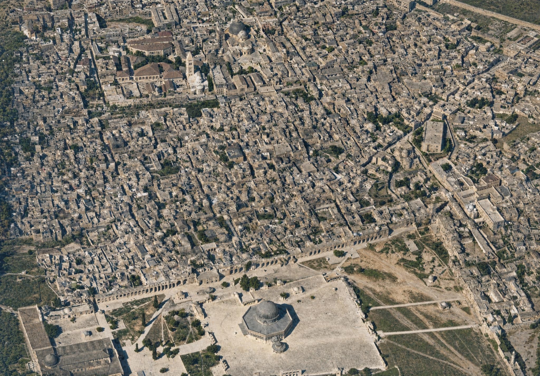
6. The Temple platform and Jerusalem. View toward the east-southeast.
Plate 6. The Temple platform and Jerusalem. View toward the east-southeast.
Photograph taken at midday.
Taken from closer range, this oblique photograph has a more three-dimensional effect than the vertical photograph in No. 5. The Haram, which corresponds to the sanctuary of the Herodian period, shows the broad area of the Temple's outermost court (), with the al-Aqsa Mosque () above an ancient approach to the Temple; the higher terrace (), the site of the innermost Temple court, with its eight approaches; the Dome of the Rock () on the site of the altar; the Dome of the Chain (); the rocky northwestern corner of the platform (), above which part of the Antonia Fortress stood; the barracks (), corresponding to the other part of the fortress; and the pool Birket Isra'in (), which has been regarded as the Pool of Bethesda.
The traditional Via Dolorosa begins at the Antonia Fortress. The Chapel of the Taking Up of the Cross (), the Ecce Homo Chapel (), and the Ecce Homo Arch () over the street; the junction of the Via Dolorosa with the road from the Damascus Gate (); the westward continuation from the corner at in the direction of ; the Church of the Holy Sepulchre with two domes (); the German Church of the Redeemer () with its cloister on the left; the Greek market, where the Hospital of the Order of St. John once stood (); the present German Hotel Fast, “St. John” (); the Patriarch's Pool (); the citadel with the Tower of David, Psephinos (), on the site of Herod's fortress; David Street from the Jaffa Gate () to the Temple platform (); beside it the courthouse, el-Mehkame (), probably the town hall in Jesus' time; and the Jews' Wailing Place () below the enclosure wall of the Temple platform.
The presumed historical Passion route of Jesus led from Herod's palace, the Tower of David, to Golgotha as the opposite height (), outside the suburb wall along the line of the market street (). The present city wall is , and the road outside it is . Compare Orte und Wege Jesu3, pp. 286ff.
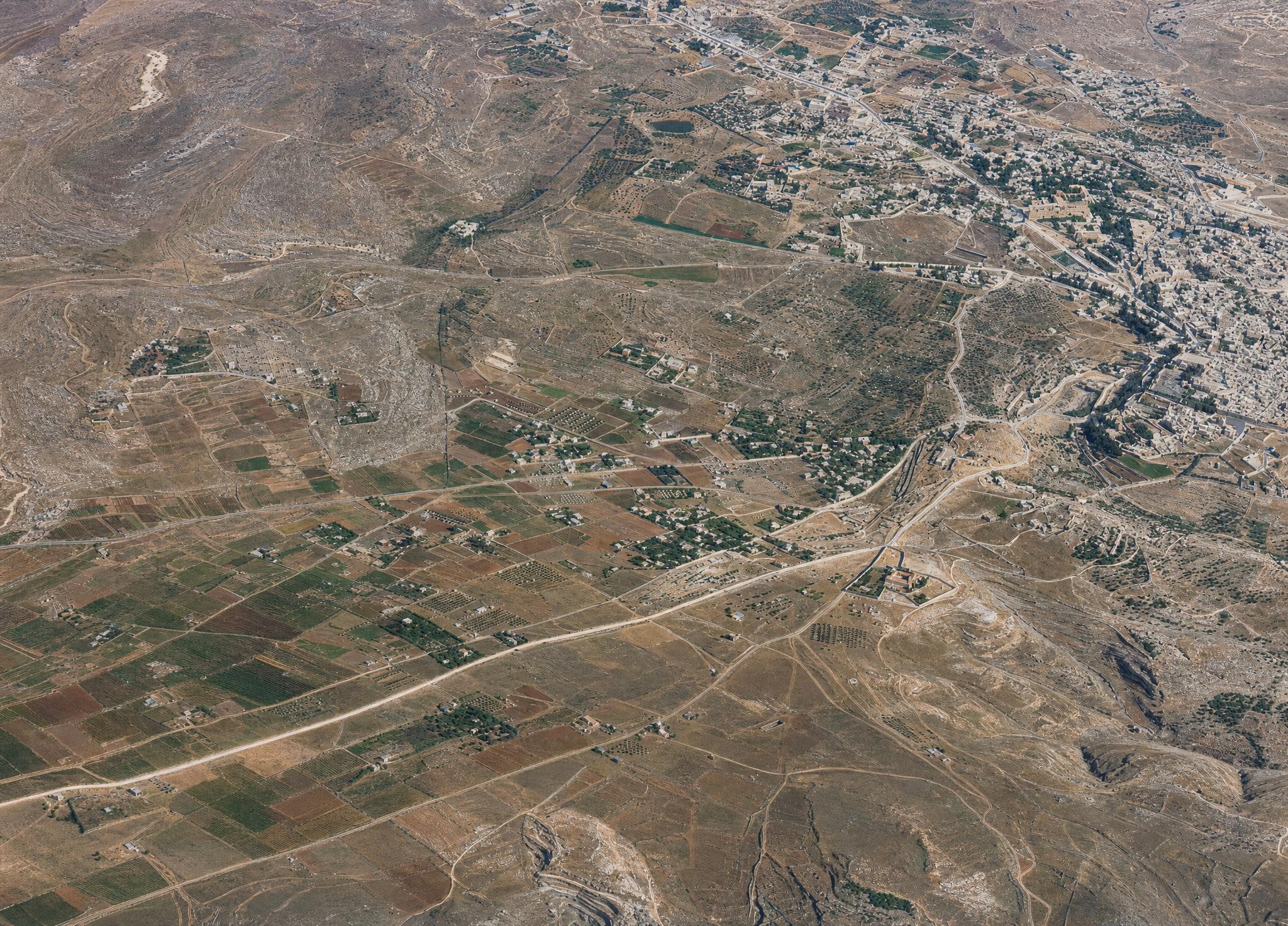
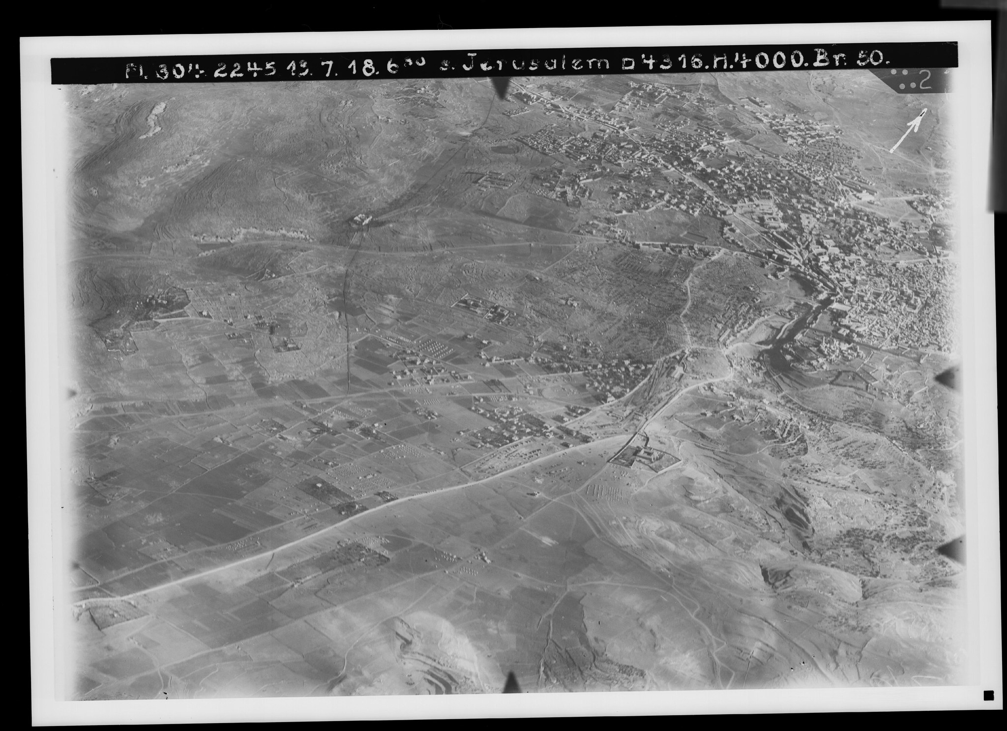
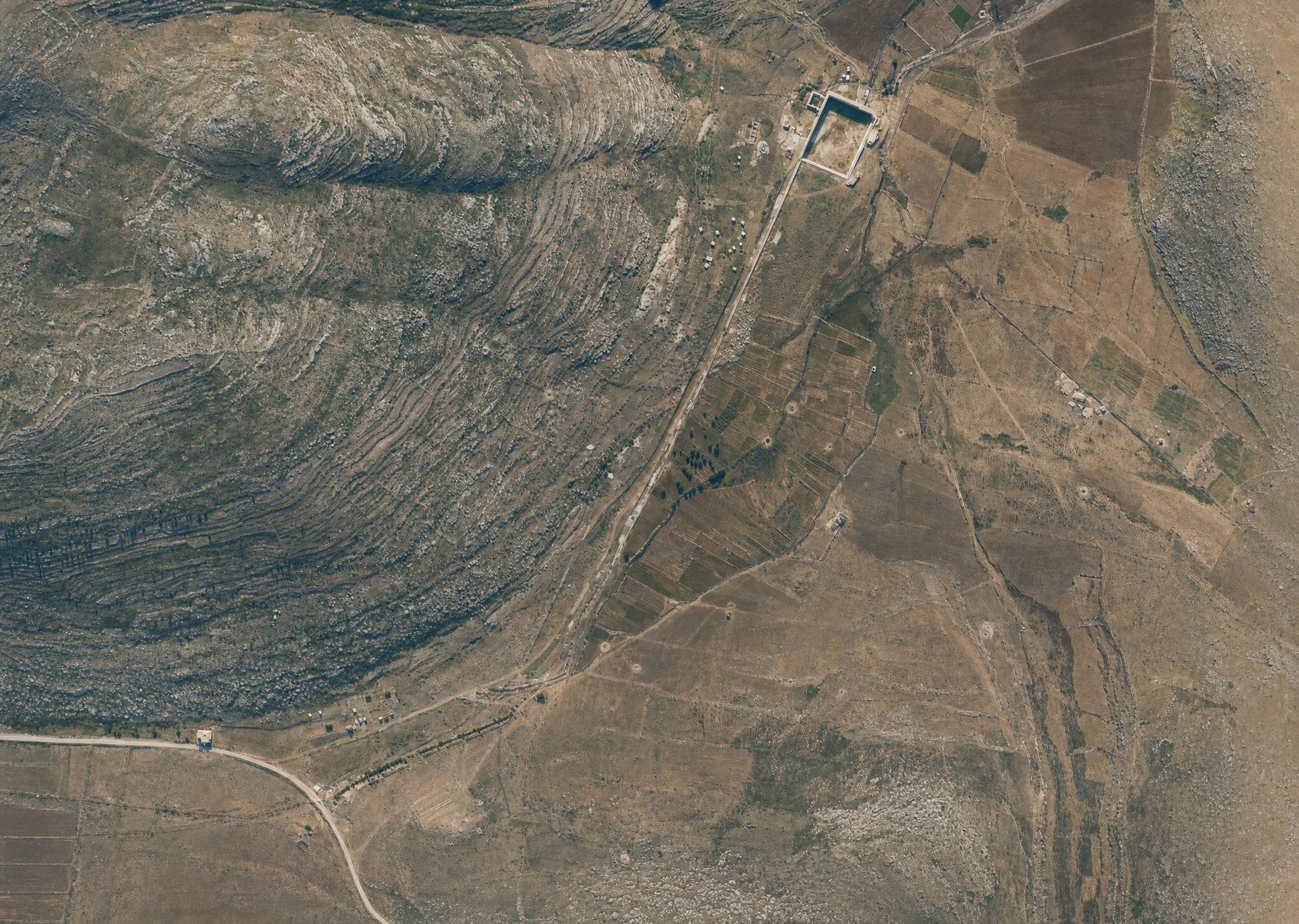
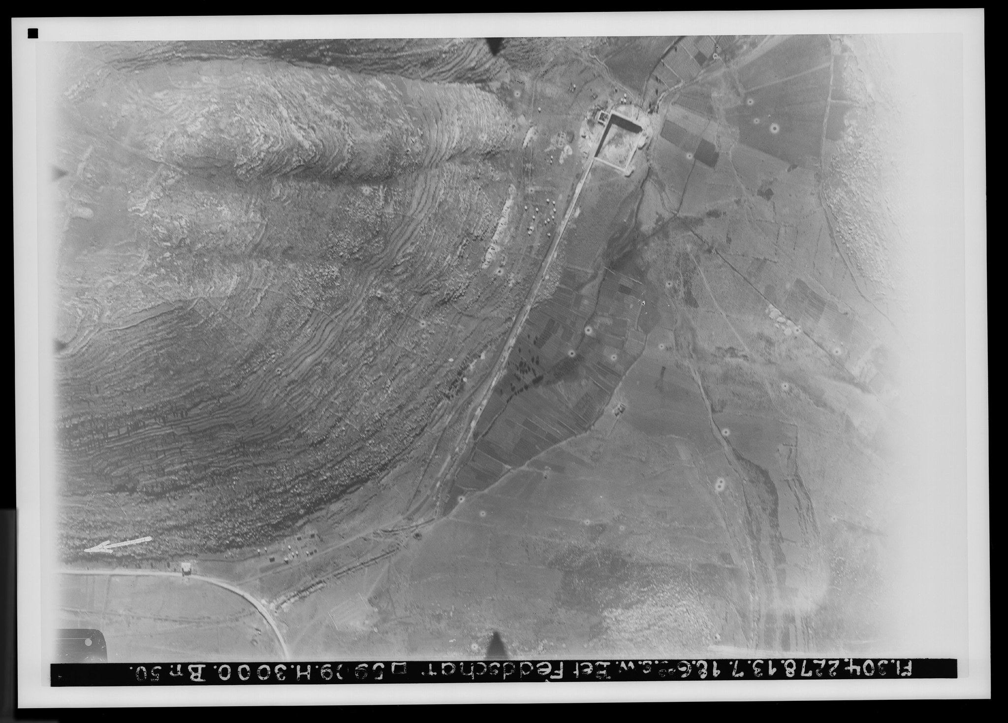
7. Jerusalem's southern surroundings. View toward the southeast. V. 784.
Plate 7. Jerusalem's southern surroundings. View toward the southeast.
FA 304, No. 2245. 13 July 1918, 6:30 a.m.; altitude 400 m; focal length 50 cm.
An autumn morning picture with shadows to the west. In the foreground the watershed runs approximately along the line of the road from to . East of it is the descent to Wadi en-Nar; west of it is the Valley of Rephaim, whose northern edge begins approximately along the line of the road from to . Here hilly terrain begins, recognizable as rocky by its lighter color and white patches. One high point is the patriarchal seat Katamon (); a valley, Wadi Ka‘at el-Uzir, lies on the line of the road to el-Malha (), with tributaries coming from the north, in the easternmost of which is the Monastery of the Cross (). To the right is Jerusalem with the Jaffa suburb, the Old City encircled by the Valley of Ben-Hinnom (), above which is the Sultan's Pool ().
The Hebron road () has almost parallel secondary lines on both sides with the same destination; a third road () runs through the plain in the direction of Beit Safafa. Of greater importance is the already mentioned road to el-Malha (), which may be regarded as the old connection to the southern coastal land and Gaza, and finally the Jaffa road (). At the station () the railway from Jaffa arrives; it first follows the Beit Safafa road () and then turns in a curve, passing over , toward the station. Noteworthy is the connecting line through the olive groves of Nikeforiye () between the Malha road and the western Hebron road, now also leading to the station. The new water pipeline built in 1918 appears as a dark line () from the ‘Arrub pool halfway to Hebron; see Nos. 11 and 37 and PJB 1921, pp. 77ff. The new Jewish colony Talpioth lies between the Hebron road and its southern parallel ().
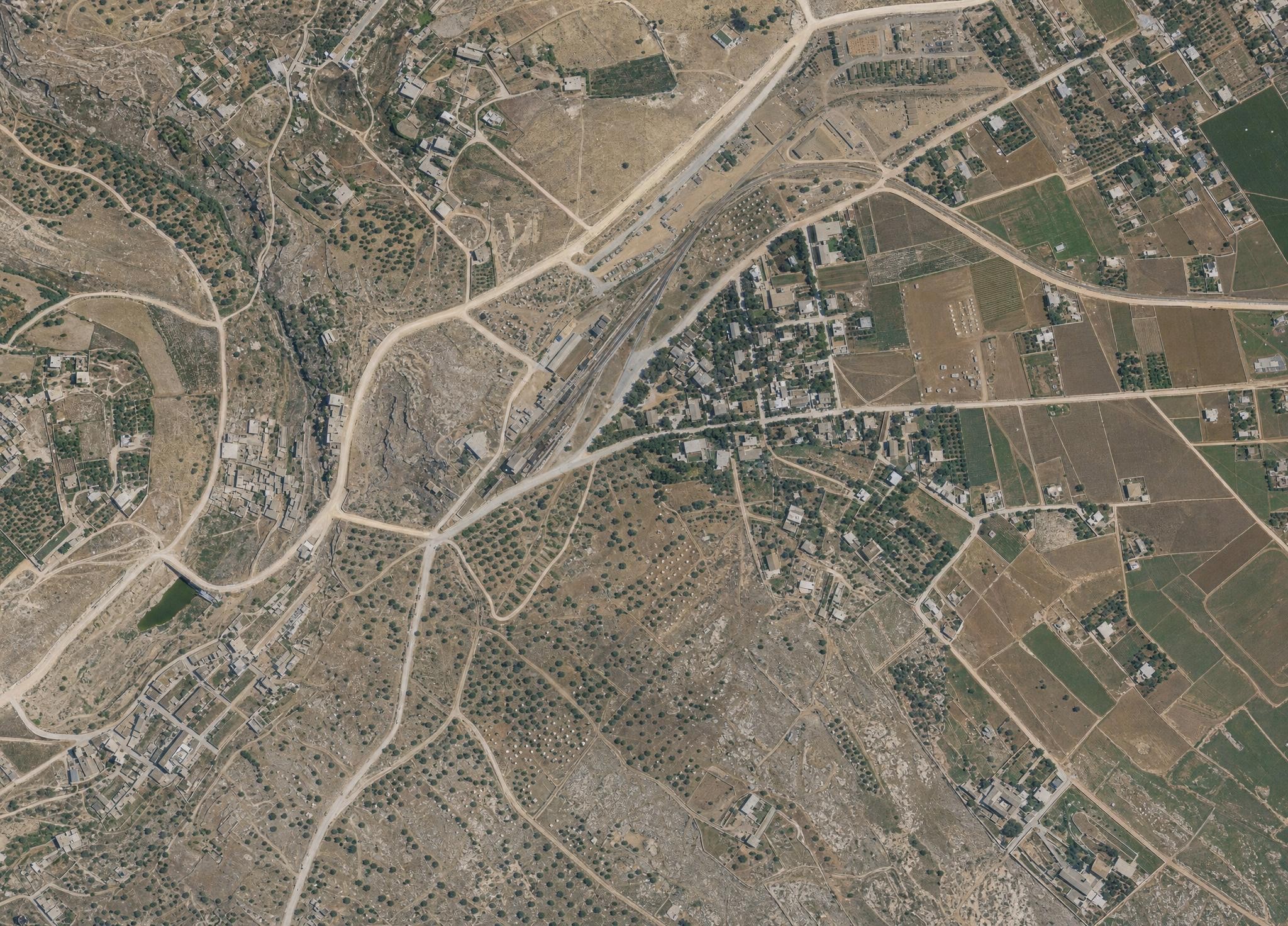
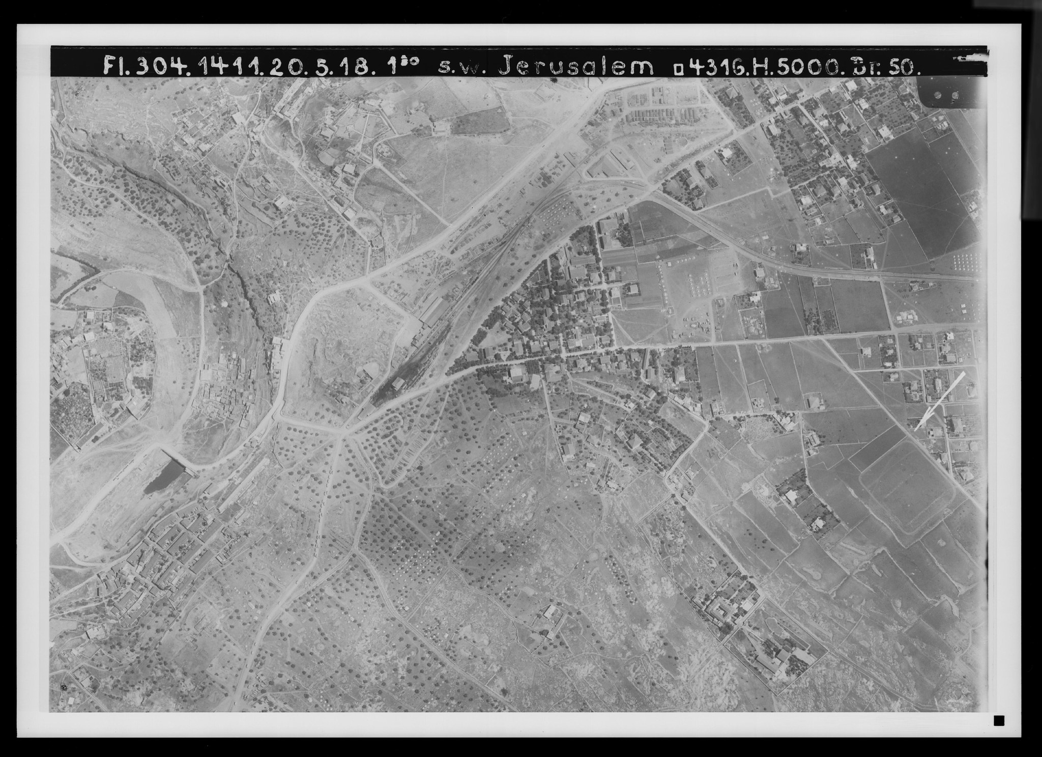
8. Jerusalem's southern suburb with the German Colony. View toward the northwest. V. 806a.
Plate 8. Jerusalem's southern suburb with the German Colony. View toward the northwest.
FA 304, No. 1411. 20 May 1918, 1:30 p.m.; altitude 5,000 m; focal length 50 cm.
A midday picture with northern shadows. The terrain lies at the point where the Valley of Ben-Hinnom turns from north-south to west-east. The Sultan's Pool, with its small surface of water (), fills the valley floor shortly before the turn, followed by a Jewish colony (). Olive plantations lie farther below (), and more extensively in the area to the west, in the foreground. The Monastery of St. Onuphrius and Hakeldama () are on the southern edge of the valley; the rock tomb of the Herodian family is at , above; and the Greek farmstead et-Talabiye () is in the west.
The so-called Mount Zion in the north, with the group of houses at Nebi Daud () and the German-English cemetery (), has opposite it, to the west, Jewish colonies (); to the south Jebel Abu Tor, the Hill of Evil Counsel (); to the southwest the rocky summit Ras ed-Dabbus (), over which the watershed bends from north to east; then the station (), the German Templer Colony (), and the leper home of the Protestant Moravian Brethren (). Below is the English sports ground ().
Historically, the area is significant because the boundary between the tribes of Judah and Benjamin ascended here from the Valley of Ben-Hinnom to the mountain north of the Valley of Rephaim and then turned northeast toward the spring of Nephtoah (Josh. 15:8f.), and because Pompey camped here in 65 BC on Jebel Abu Tor (Jewish War V.12.2). A village called “Kichererbsenhausen” probably occupied Ras ed-Dabbus at that time (Jewish War, same passage).
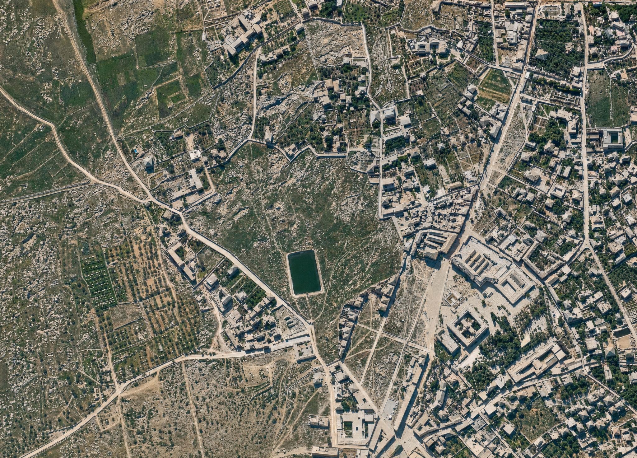
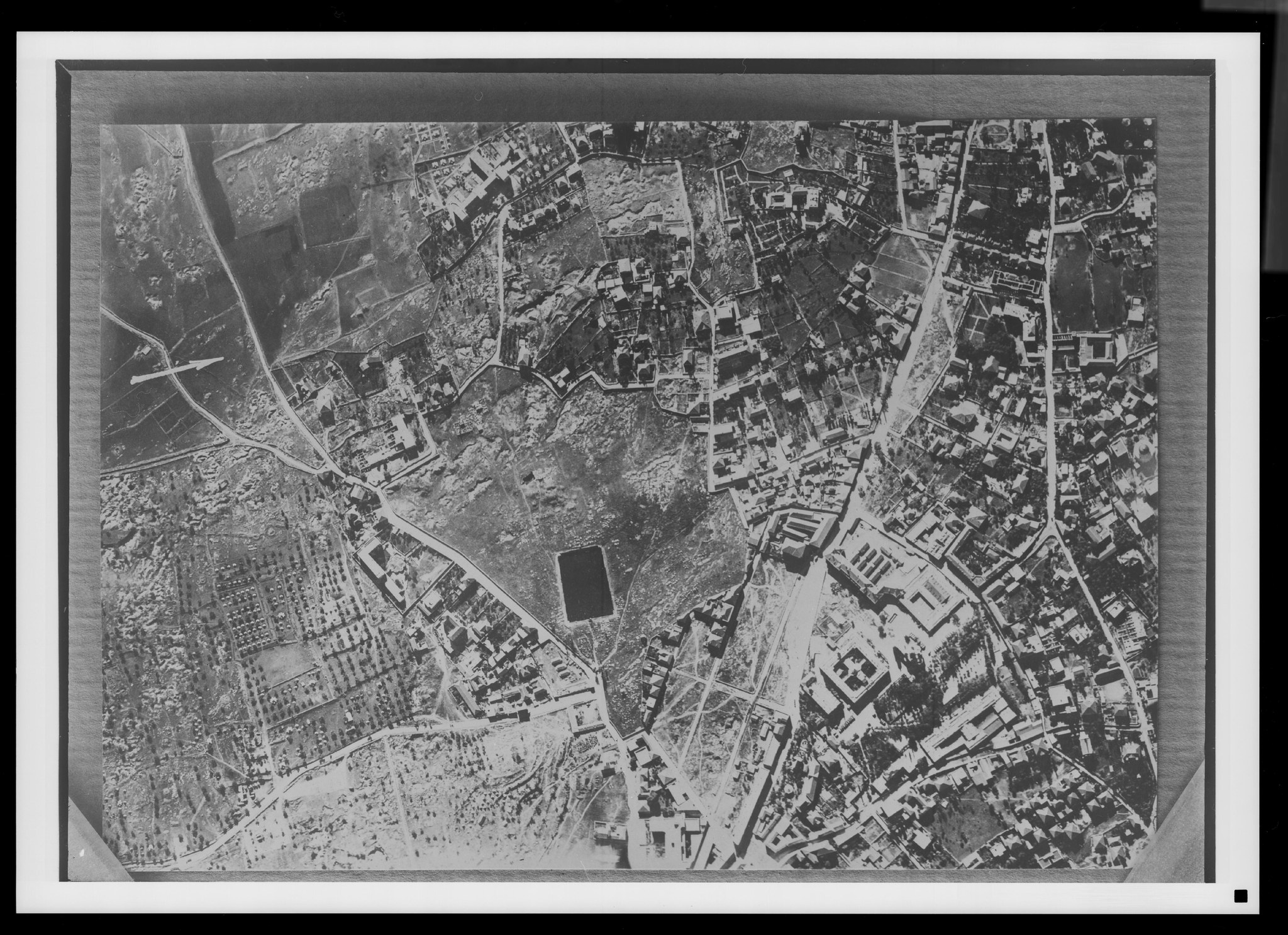
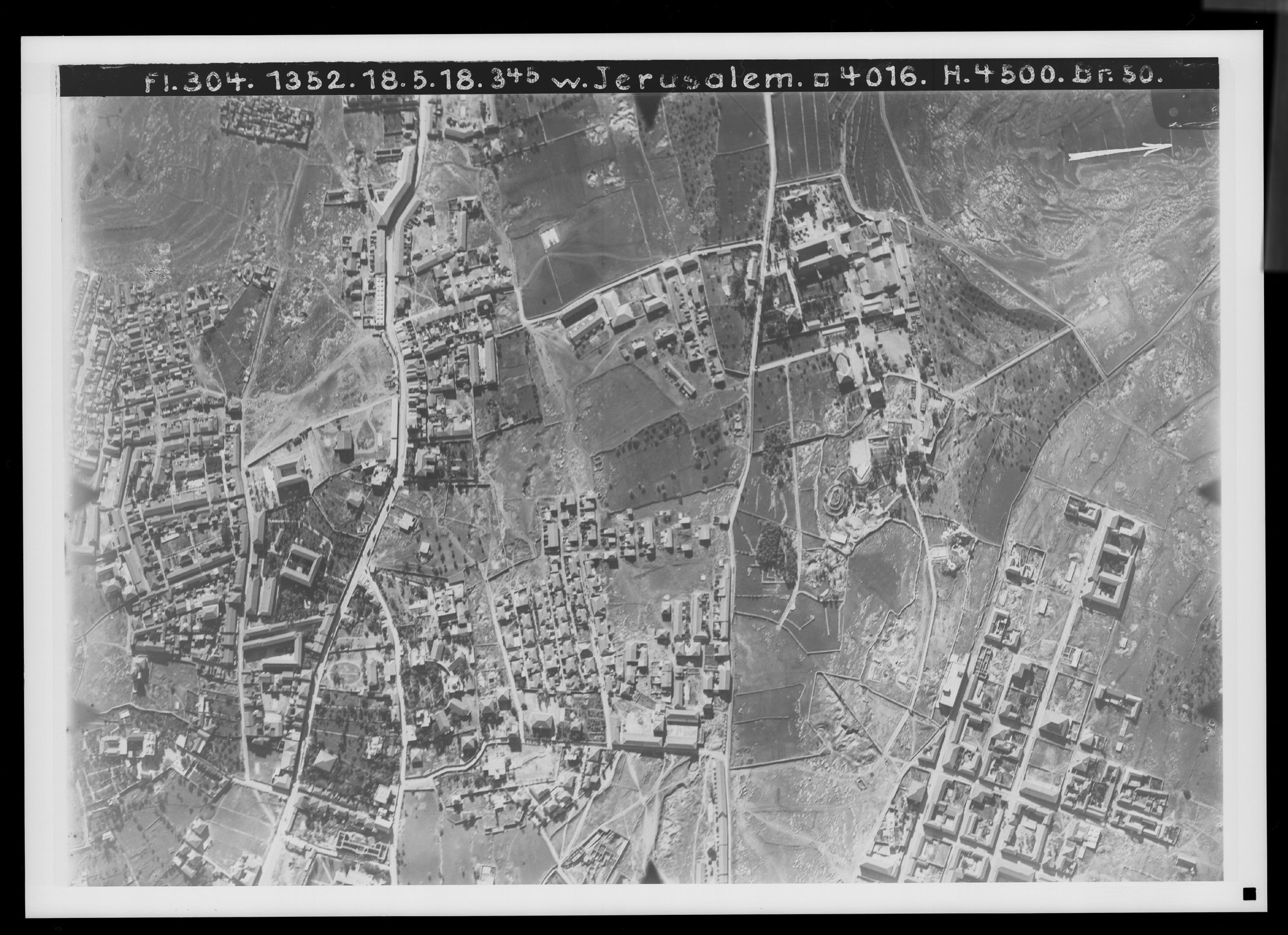
9. Jerusalem's inner western suburb. View toward the east. V. 799.
Plate 9. Jerusalem's inner western suburb. View toward the east.
FA 304, No. 1354. 18 May 1918, 3:45 p.m.; altitude 4,500 m; focal length 50 cm.
In the center is the Mamilla Pool (), the collector of rainwater from the surrounding depression, with which the Valley of Ben-Hinnom is connected, still filled now in May. It is surrounded by a Muslim cemetery, around which traffic must find its way. From the northeastern corner of the Old City, near , the Jaffa road runs to ; along it are the small city garden () and the Russian Compound with its church (), pilgrims' houses, and administrative buildings (), now used for other purposes. Set apart is Talitha Kumi, the girls' orphanage of the Kaiserswerth deaconesses (). The connecting road from the Jaffa road to the Damascus Gate () has beside it the hospital of the London Jewish Mission (), the German consulate (), the German hospital of the Kaiserswerth deaconesses (), and the German Protestant parsonage (). Set apart are the domed Ethiopian church () and the former house of the German Protestant Palestine Institute (, left), the American Palestine Institute (, below), and the chapel of the English church mission ().
Far to the west are the Ratisbonne school for Arab children () and the Jewish Bezalel School of Arts and Crafts (). By the Mamilla cemetery is the old hospice of the Catholic German Association of the Holy Land (). On the left is the road to el-Malha (), with a connecting road to the station () through Nikeforiye with military tent camps, and the road to ‘Ain Karim, first toward the Monastery of the Cross (). In the area of the Mamilla Pool one may locate the Fuller's Field, on whose road, and also at the starting point of the conduit from the upper pool, Isaiah was to meet King Ahaz (Isa. 7:3). The “Camp of the Assyrians” belongs in the area of the Russian Compound (2 Kings 19:35); Titus too set up the camp there from which he conquered Jerusalem (Jewish War V.3.5; V.12.2).
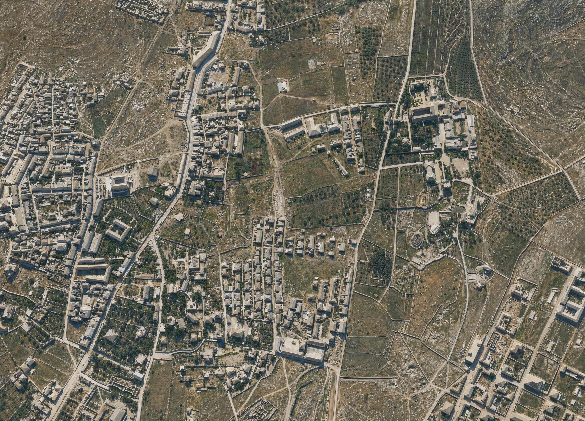
10. Jerusalem's outer western suburb. View toward the southeast. V. 800a.
Plate 10. Jerusalem's outer western suburb. View toward the southeast.
FA 304, No. 2588. 1 August 1918, 12:30 p.m.; altitude 4,500 m; focal length 50 cm.
The upper-right corner of picture 9 is repeated here in the lower center. The Jaffa road and the connecting road from the Damascus Gate meet at . Talitha Kumi (), the German parsonage (), the hospital (), the consulate (), and the Jewish mission hospital () are also visible here. New along the Jaffa road are the schools and workshops of the Alliance Israélite () and, far outside, the Jewish Shaare Zedek Hospital (). To the right of the Jaffa road and along the left parallel road are Jewish colonies; at is the Yemenite colony, and the pool Birket el-Khandak is at . Jewish colonies also lie to the north and east, and the Jewish von Lämel School is at .
A depression that drains eastward through Wadi Lukka toward the upper course of the Kidron Valley corresponds to the northern road parallel to the Jaffa road (). On its right side lies the property of Pastor Schneller's Syrian Orphanage, founded in 1860, though the orphanage itself is no longer visible; on the height is “Abraham's Vineyard,” an English Christian foundation for Jewish workers (), and beyond it the Jewish Bukharan Colony ().
Everything west of Jerusalem was without houses until 1859. Only from then on did Christian institutions, and then especially Jewish immigrants, begin to settle the terrain along the Jaffa road. Grain fields and olive groves, in which tents were pitched for summer recreation, and individual watchtowers securing the road accompanied the pilgrim coming from Jaffa as far as the city gate. David too traveled this road when he brought the Ark of God to his city (2 Sam. 6:12); compare PJB 1913, p. 36; 1921, pp. 95, 103.
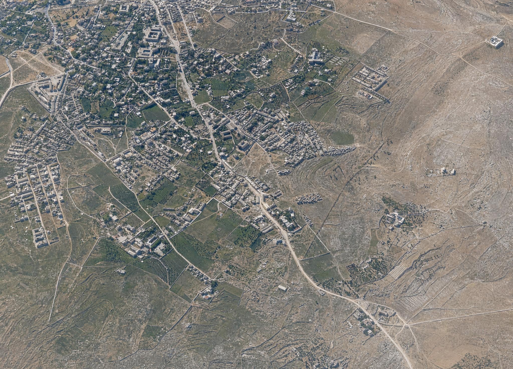
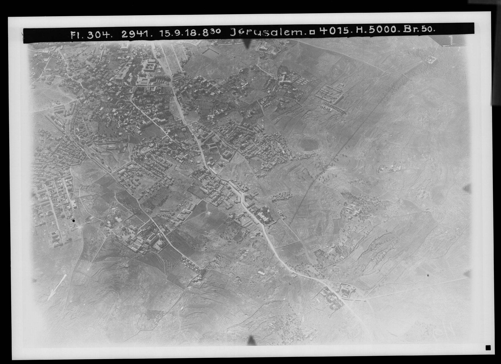
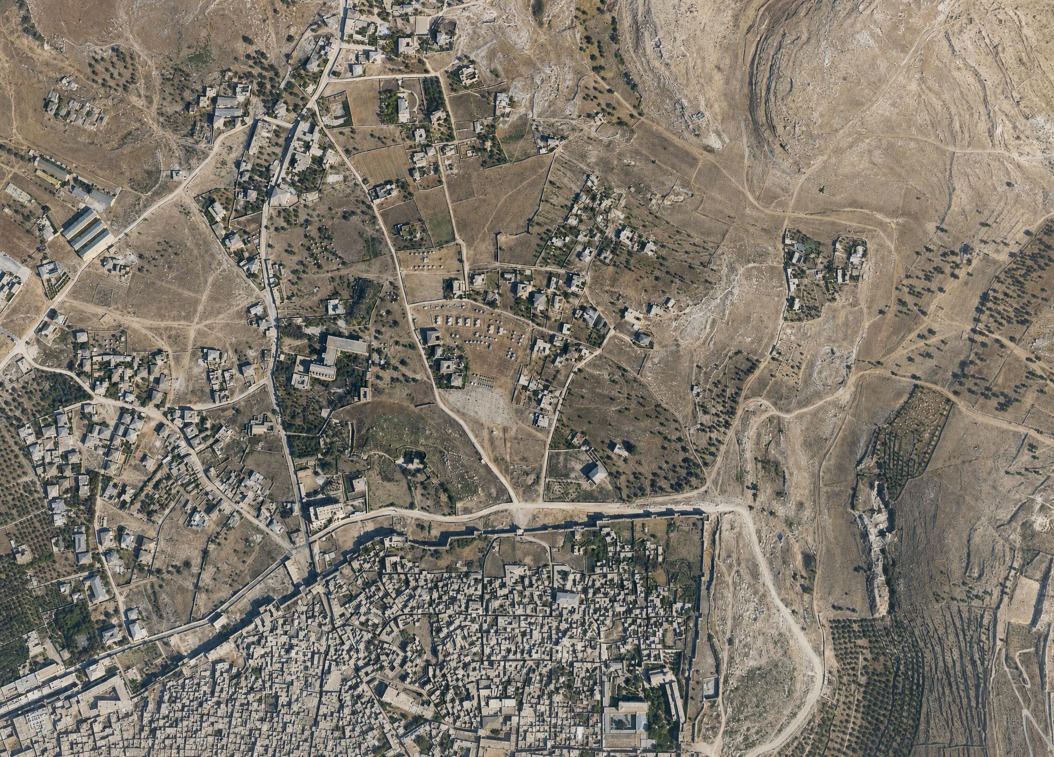
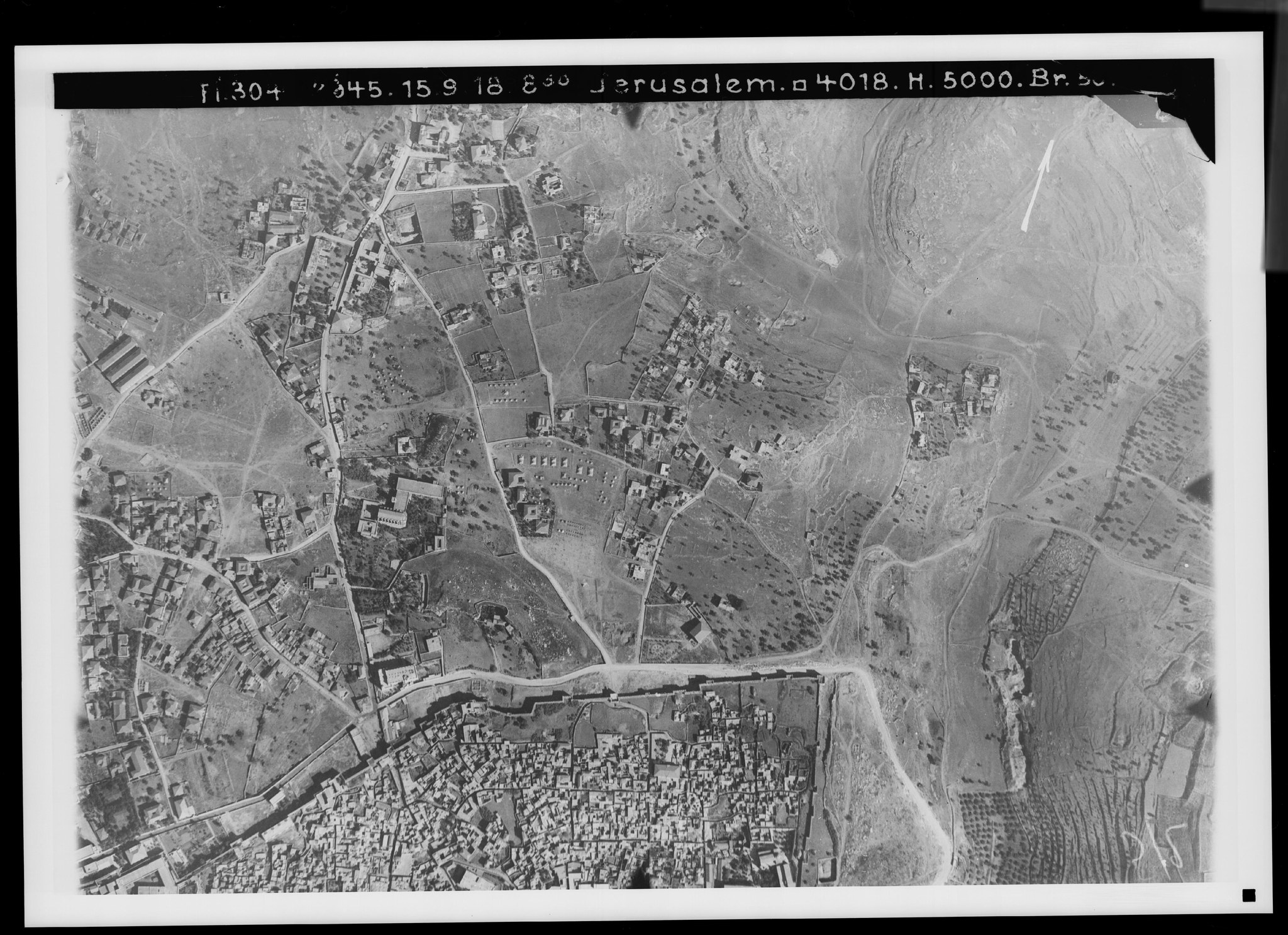
11. The entire western suburb of Jerusalem. View toward the northwest. V. 787.
Plate 11. The entire western suburb of Jerusalem. View toward the northwest.
FA 304, No. 2941. 15 September 1918, 8 a.m.; altitude 5,000 m; focal length 50 cm.
This view reaches even farther west than No. 10, showing the western suburb from the outside. Here the Jaffa road begins in the area of its greatest height, 819 m (), north of which the ground reaches its highest point at 828 m (). The watershed between the Mediterranean and the Dead Sea runs as far as this point, because the shallow depression that continues from here over Wadi Lukka toward is connected with the Kidron Valley.
On the north the watershed line follows past the Syrian Orphanage () (formerly Khirbet Bedr) and Abraham's Vineyard (), running toward the Karm el-Ka‘k north of Jerusalem (see No. 12). On the south it follows the Jaffa road as far as the former government hospital () and encircles the Mamilla cemetery () on the west and south. The valley of Wadi esh-Sheikh, which runs down from the Jaffa road () to the Monastery of the Cross (), already belongs to the descent toward the Mediterranean. The water conduit from the ‘Arrub pools (compare Plate 7) climbs up it to its settling basin () and carries the water from this high point into the city.
The ridge with the tomb of Sheikh Bedr () bounds this valley on the west; beyond it adjoins Wadi Sahyun, which likewise runs northward and along whose western side the road to ‘Ain Karim passes by. Where this road branches off from the Jaffa road (), Jewish old-age homes () and a Jewish asylum () stand beside it.
Olives on the height of Sheikh Bedr and in the valley by the Monastery of the Cross (), young pine plantations near the Syrian Orphanage (), and others on the slope of Ras en-Nadir () are important representatives of the tree life in the west of Jerusalem. The pool Birket el-Khandak () collects only rainwater. For the relief of the landscape compare Plate 1.
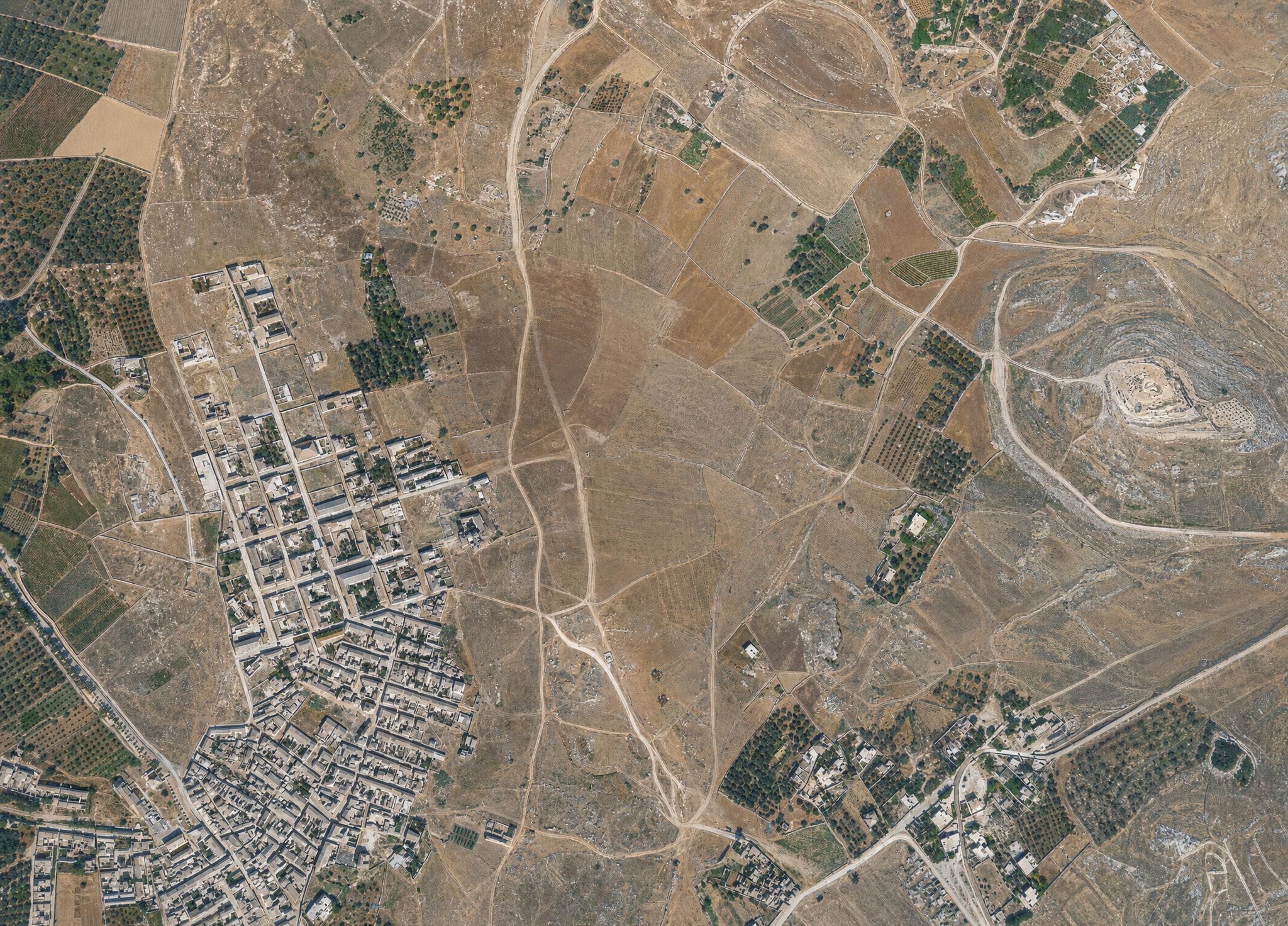
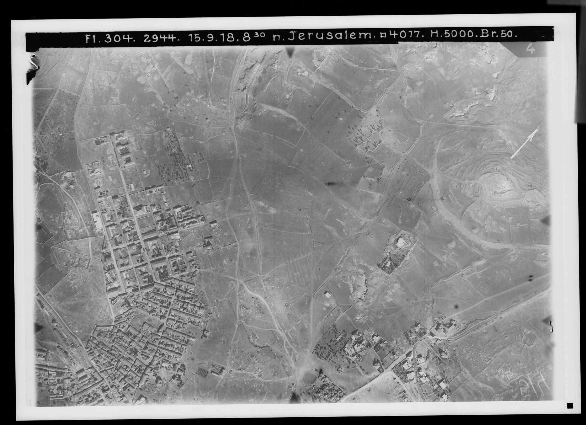
12. Northwest of Jerusalem. View toward the southeast. V. 801.
Plate 12. Northwest of Jerusalem. View toward the southeast.
FA 304, No. 2944. 15 September 1918, 8:30 a.m.; altitude 5,000 m; focal length 50 cm.
A morning view that links No. 11 with No. 13. The seemingly level area in the center is crossed by the watershed, which, coming from the Syrian Orphanage, runs across this area roughly through its middle and passes over toward the height of the Karm el-Ka‘k (). To the north the ground slopes down toward Wadi Umm el-‘Amad (no longer visible), to the south toward the basin of the pool Birket en-Nka‘ () and the upper course () of Wadi ed-Joz that passes north of it — that is, once again, part of the Kidron Valley.
The land here, used for farming, was once important — especially along the northern slope — because of the burial chambers that were cut into these rocky edges (e.g. ). On the left is the handsomely laid-out colony of the Bukharan Jews (); south of it are more densely built Jewish colonies, of which Mea Shearim (Meshorim), on the road coming from the Syrian Orphanage (), is the best known. Beyond the depression are the outermost groups of houses of the northern suburb, here too a Yemenite colony ().
The northern road out of Jerusalem () crosses the valley on an embankment (), then climbs steeply (), a stretch that a switchback bypasses to the east (). Across the level ground comes from the north () the road from Bet Hanina, ed-Jib–Gibeon, and Nebi Samwil; at it divides into the routes to the Damascus Gate () and to Herod's Gate (), with the footpath from Sho‘fat () being less important. Apart from the grounds of the Syrian Orphanage () and Abraham's Vineyard (), and a few gardens, there is hardly a tree in the whole area.
13. Jerusalem's northern suburb. View toward the south. V. 796.
Plate 13. Jerusalem's northern suburb. View toward the south.
FA 304, No. 2945. 15 September 1918, 8:30 a.m.; altitude 5,000 m; focal length 50 cm.
Fairly level ground adjoins the Old City on the north. Yet the ascent toward the watershed in the west () is followed by a shallow depression (), then the beginning, at 778 m, of Jerusalem's eastern hill — artificially separated by the city wall from its southern continuation (). Now called es-Sahira, it was held by Thenius and others to be Golgotha (), and is famous for the supposedly genuine Tomb of Christ on its western edge (). After a second depression () comes a second low rise, the Karm esh-Sheikh (), before the descent to the Kidron Valley. This valley () encircles the northern suburb on the east and northeast and receives a tributary from the north (). There are larger stands of olives in various places — gone since the war at — and a large pine in the Karm esh-Sheikh ().
From the Damascus Gate () runs the northern road; east of it stand the German Catholic St. Paul's Hospice (), the French Dominican monastery (), the church of the English bishop (), and the main house of the “American Colony” (). Roads lead to the Jaffa Gate () and to Herod's Gate (), beside which is the tomb of the royal family of Adiabene (); roads toward Bet Hanina, see No. 12 (); to ‘Anata–Anathoth (); the road to Jericho (); and the road from the Damascus Gate to the Jaffa road (), compare Nos. 9 and 11.
Together with Nos. 9–12, this picture amounts to a plan of the northern and western suburbs of Jerusalem of a kind not previously available. Not only the exact position of every road, but every individual property, is rendered clearly and with complete reliability.
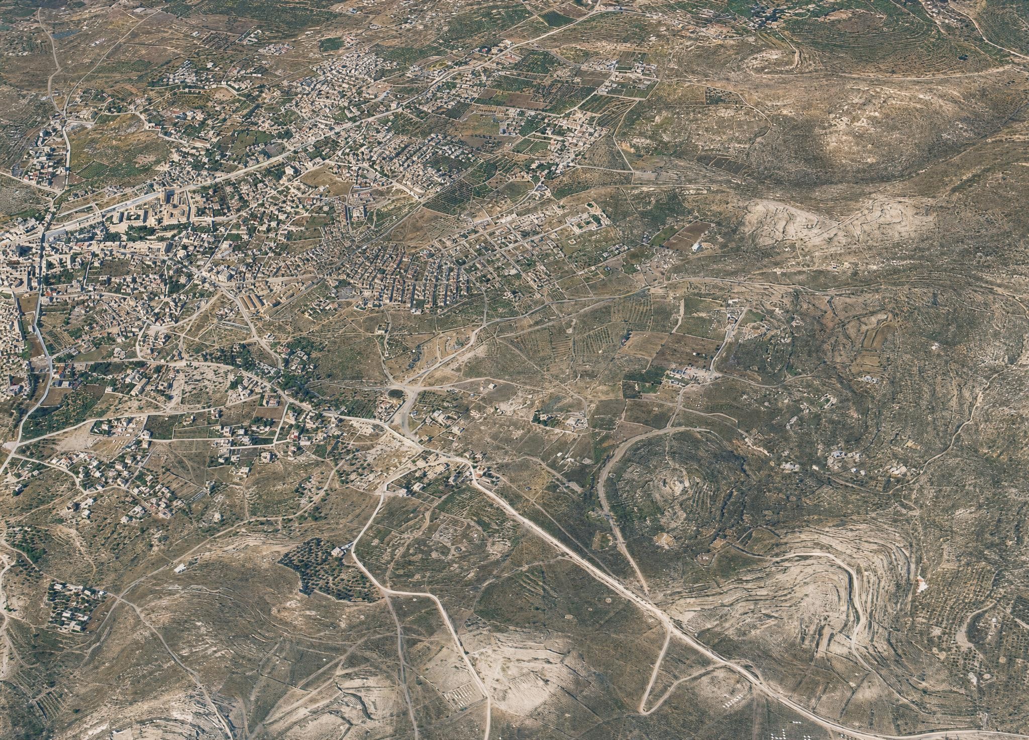
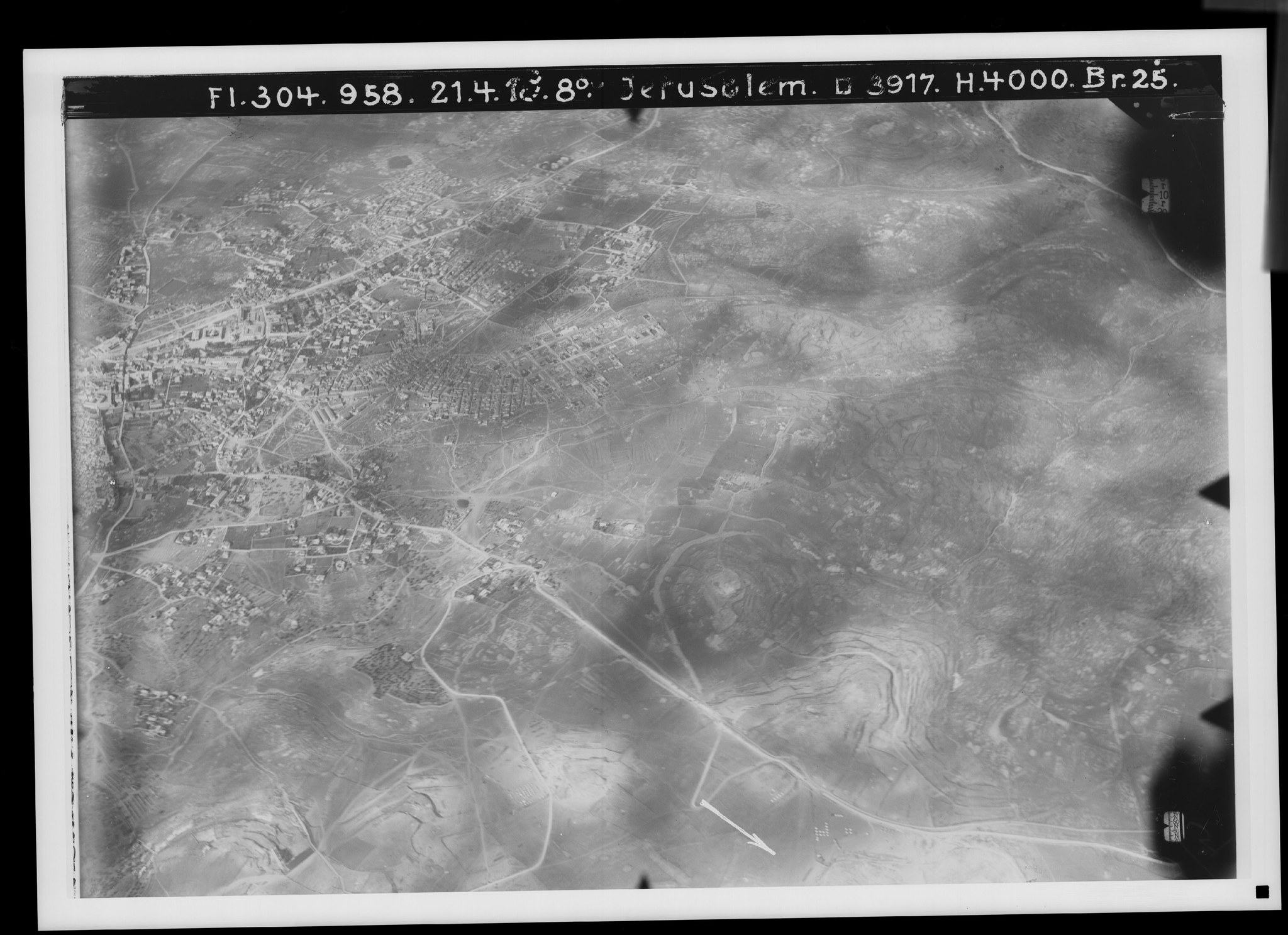
14. North and northwest of Jerusalem. View toward the northeast. V. 788.
Plate 14. North and northwest of Jerusalem. View toward the northeast.
FA 304, No. 958. 21 April 1918, 8 a.m.; altitude 4,000 m; focal length 25 cm.
The picture surveys the entire western and northern suburb from the north wall onward (): the Jaffa road as far as the Jewish old-age homes beyond the watershed (), and the northern road () to just short of Sho‘fat, about 3½ km. New here is the ground north of the Karm el-Ka‘k (), above all Ras el-Mesharif with its western spur (), 779 m high, where the watershed crosses over to the east and then continues northward.
At it begins Wadi Umm el-‘Amad (), which empties into Wadi Bet Hanina (Lifta) (). Cloud shadows darken its southern slopes and hang over the suburb. In its full length the valley appears below the Syrian Orphanage ().
Not everywhere distinct is the road to Bet Hanina (), beside which lies the so-called Tomb of the Judges (), and its branch toward Bet Iksa (); entirely clear are the northern road with its switchback at Ras el-Mesharif and the fork toward Jeba‘ (), and the Mount of Olives road with its shortcut () leading to ‘Anata, like the road from the corner of the city ().
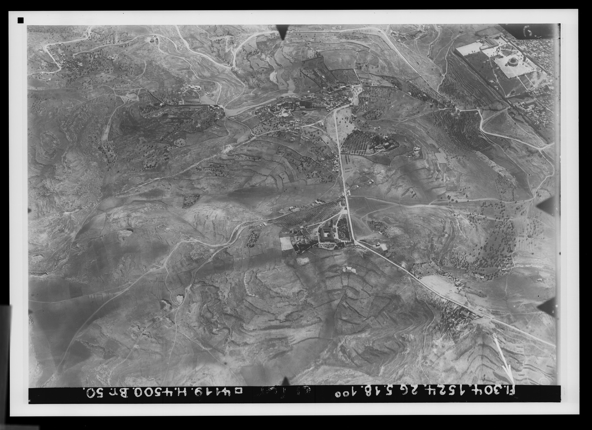
15. The Mount of Olives range. View toward the north. V. 836.
Plate 15. The Mount of Olives range. View toward the north.
FA 304, No. 1524. 26 May 1918, 1 p.m.; altitude 4,500 m; focal length 50 cm.
The Mount of Olives is the southernmost peak of a ridge running first to the southeast and then to the south, as the Mount of Olives road indicates (). The mountain itself divides into the Ascension summit (815 m), with the Ascension shrine and the village of et-Tur (); the Russian summit (818 m), with the Russians' tall bell tower (); and the Galilee summit (813 m), with a Greek church for the event of Matt. 28:16ff. (). After a slight dip in the ridge there follow, to the north, the German summit — Arabic Umm et-Tala‘ (813 m) — with the hospice of the Empress Augusta Victoria Foundation (), and the Jewish summit — Arabic el-Madbase (831 m) — which is to carry the Hebrew University ().
East of the Russian summit adjoins the much lower Ras esh-Shiyah, now settled again (). Together with the Mount of Olives ridge, the eastern fall of the Russian summit forms the watershed between Wadi en-Nar and Wadi es-Sidr. To the basin of the former belong Wadi Kaddum () in the south and the Kidron Valley () in the west, while the eastern valleys belong to the basin of Wadi es-Sidr — more precisely, as far as Umm et-Tala‘ to Wadi el-Lehham (), and then as far as el-Madbase to Wadi Merajir ed-Daba‘. The small plain of Ibke‘dan () thus belongs to the latter. Ras et-Tmim (probably ) has lately been proposed as Bahurim.
The important routes, besides the carriage road up the Mount of Olives, are the carriage road to Jericho (), which skirts the mountain on the south, and then three paths leading over the ridge to the same destination. The first passes over the Ascension summit, by the Bethphage chapel (), and runs either by way of el-‘Azarije–Bethany () or directly () to the Jericho road. The second crosses the Mount of Olives south of the Ascension summit () and reaches the carriage road along Wadi el-Lehham (). The third, once a Roman road, skirts Umm et-Tala‘ on the south () and joins the carriage road only halfway to Jericho. For Jesus' road from Jericho to Jerusalem all three must be considered; the northernmost is the most likely.
For the relief of the Mount of Olives ridge compare No. 2, and Orte und Wege Jesu³, fig. 30 (an aerial view of the Mount of Olives ridge from the east).
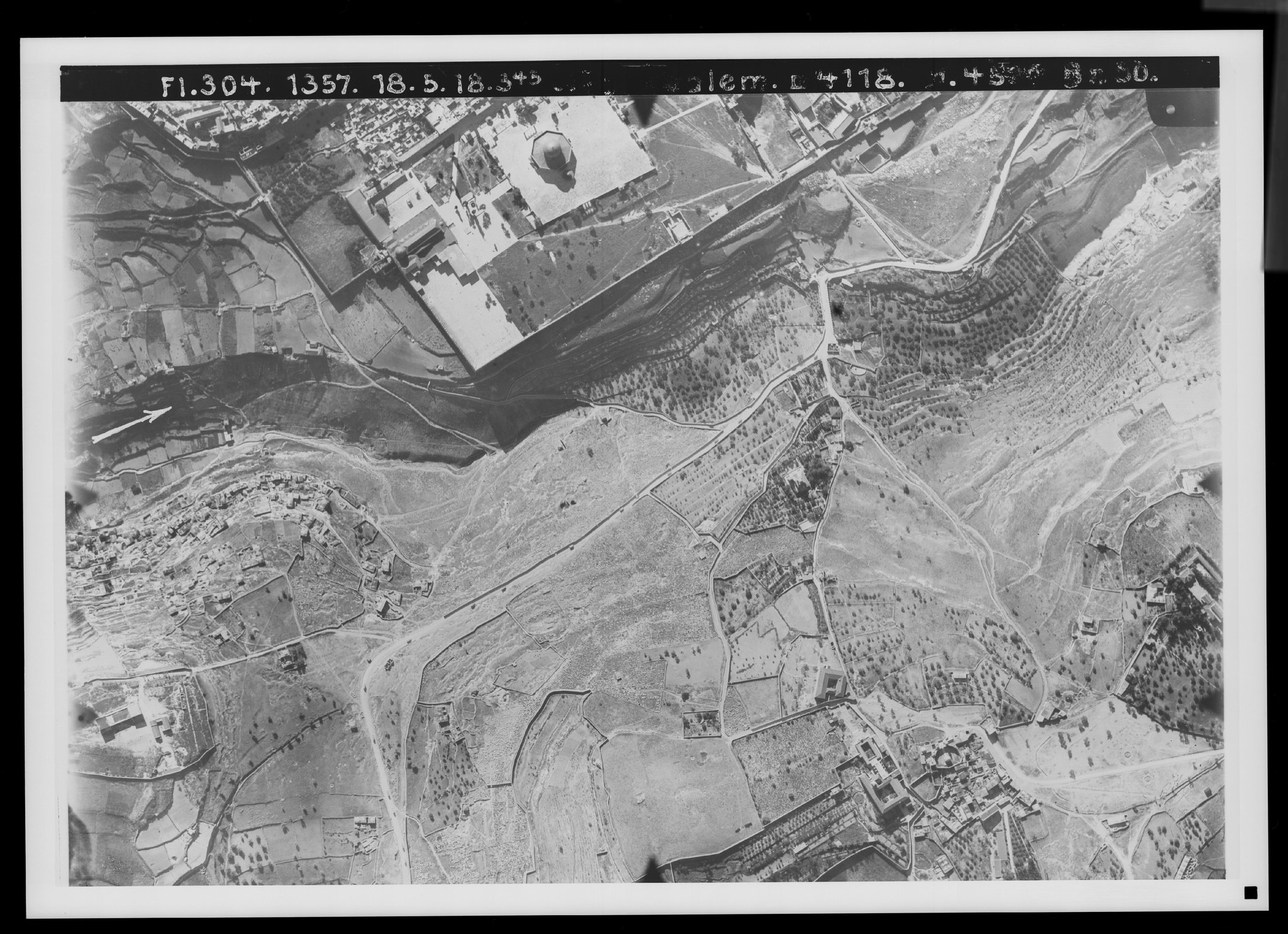
16. The Mount of Olives and the Kidron Valley. View toward the southeast. V. 792.
Plate 16. The Mount of Olives and the Kidron Valley. View toward the southeast.
FA 304, No. 1357. 18 May 1918, 3:15 p.m.; altitude 4,500 m; focal length 50 cm.
On the Mount of Olives are visible the Ascension summit, with the round Ascension shrine () and the Carmelite convent () with the Pater Noster shrine (), and the Galilee summit (). The western slope shows its three paths to Jerusalem: the northern one, with its bend at the so-called Tombs of the Prophets (), probably once continuing straight toward the Bethphage chapel; the middle one, at the site of Jesus' Weeping (Luke 19:41) (); and the southern one, which now bends up toward the Ascension summit (), but originally continued over the saddle between the Ascension and Galilee summits and also offered a connection to the Roman road (see No. 15).
The Franciscan garden of Gethsemane lies near the foot of the mountain (), with the site of the now-rebuilt old church beside it on the south; above it is the Russian Church of Mary Magdalene (), below it the Tomb of the Virgin () and the Grotto of the Agony (). The Jericho road crosses the valley floor here () and then runs along the near side of it, over the bare slope covered with Jewish gravestones.
In the valley below — formerly planted with olives — are the Tomb of Absalom (), the Tomb of St. James and the Tomb of Zechariah (), the Spring of the Virgin (formerly Gihon) (), and the Arab village of Silwan (). Among the routes to the city, note the detour of the carriage road to St. Stephen's Gate (), the road to the David Gate (), which probably corresponds to an old road, and its former connection to the southern Mount of Olives paths (). The Golden Gate () of the Temple Mount remains without a direct approach. Compare Orte und Wege Jesu³, pp. 273ff., 338ff.
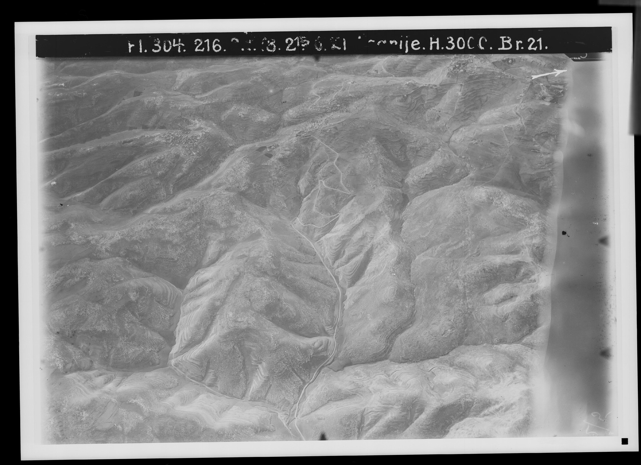
17. The Jericho road I (descent from Bethany). View toward the northeast. V. 844.
Plate 17. The Jericho road I (descent from Bethany). View toward the northeast.
FA 304, No. 216. 3 January 1918, 2:15 p.m.; altitude 3,000 m; focal length 21 cm.
The fall toward the desert from the southern end of the Mount of Olives ridge is broken up by a number of valleys. To the Wadi es-Sidr system belongs Wadi es-Sikke, called Wadi el-Hod in its upper course (), with its tributaries: on the left Wadi ed-Jemel (), on the right Wadi ‘Arak Nazil, or Wadi el-Lehham (), which comes from the Mount of Olives, and Wadi Mrajir ed-Daba‘, beginning at the Ibke‘dan depression (). From Bethany comes Wadi Abu Dis (), which belongs to a second main branch of Wadi es-Sidr. At the edge of the picture Wadi en-Nar is touched (). From the 818 m of the Mount of Olives the ground falls to el-‘Azarije (615 m) by 200 m, and a further 300 m to the junction of Wadi ed-Jemel with Wadi es-Sikke (about 400 m).
Settlements: el-‘Azarije–Bethany, in two parts (), and the history-less Abu Dis (), the outermost outposts of the settled land toward the desert.
The Jerusalem–Jericho carriage road can be traced from Wadi Kaddum () over el-‘Azarije to Wadi es-Sikke (); besides it, the path over Bethphage to the road (), the path through Wadi el-Lehham (), the Roman road () with a connecting path toward Wadi el-Lehham (), and the path from Abu Dis to Jerusalem () as a dark line. — The arrow is inexact.
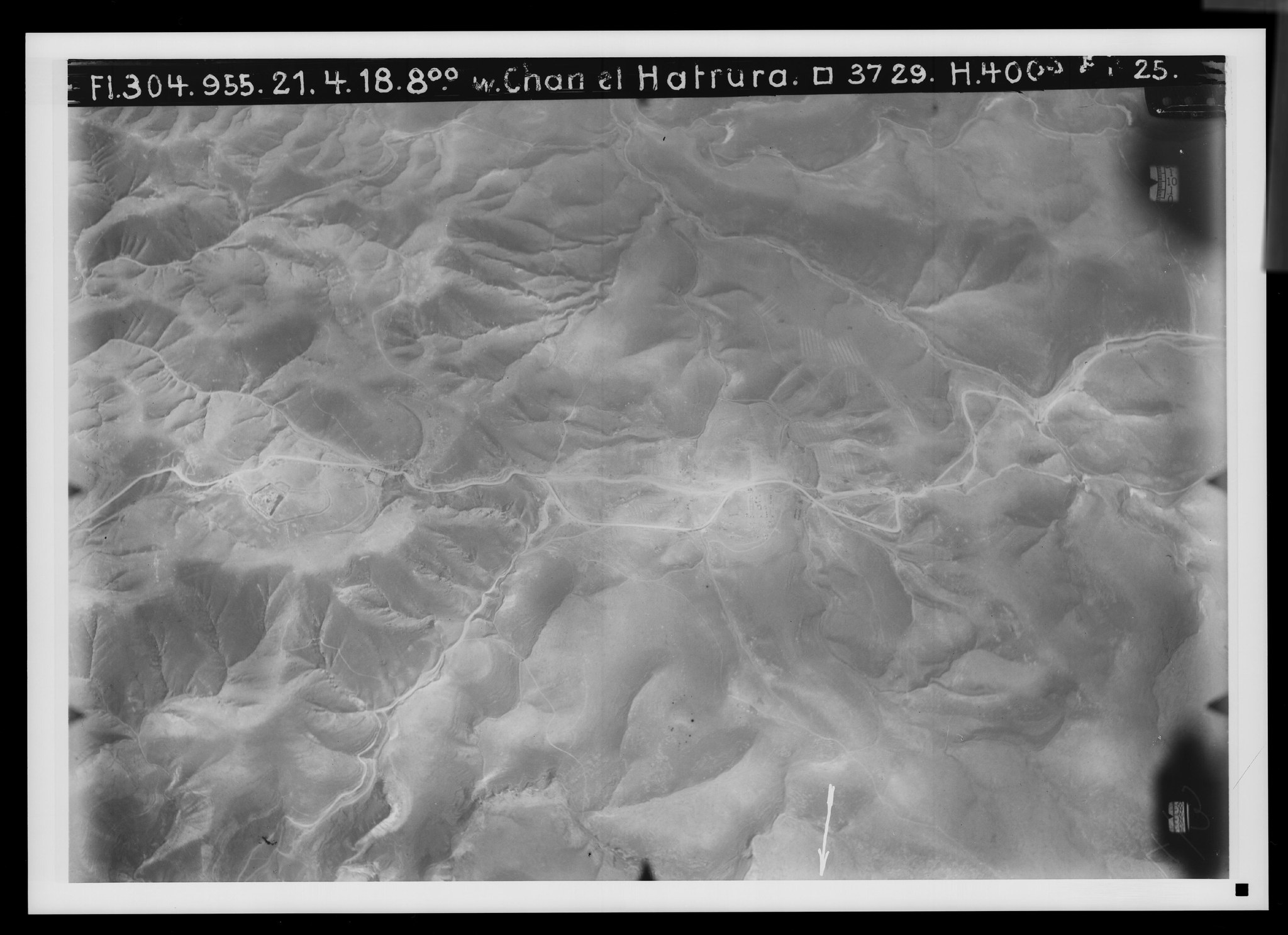
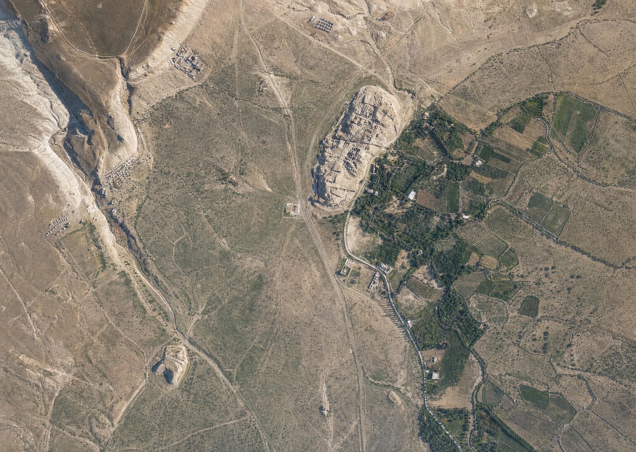
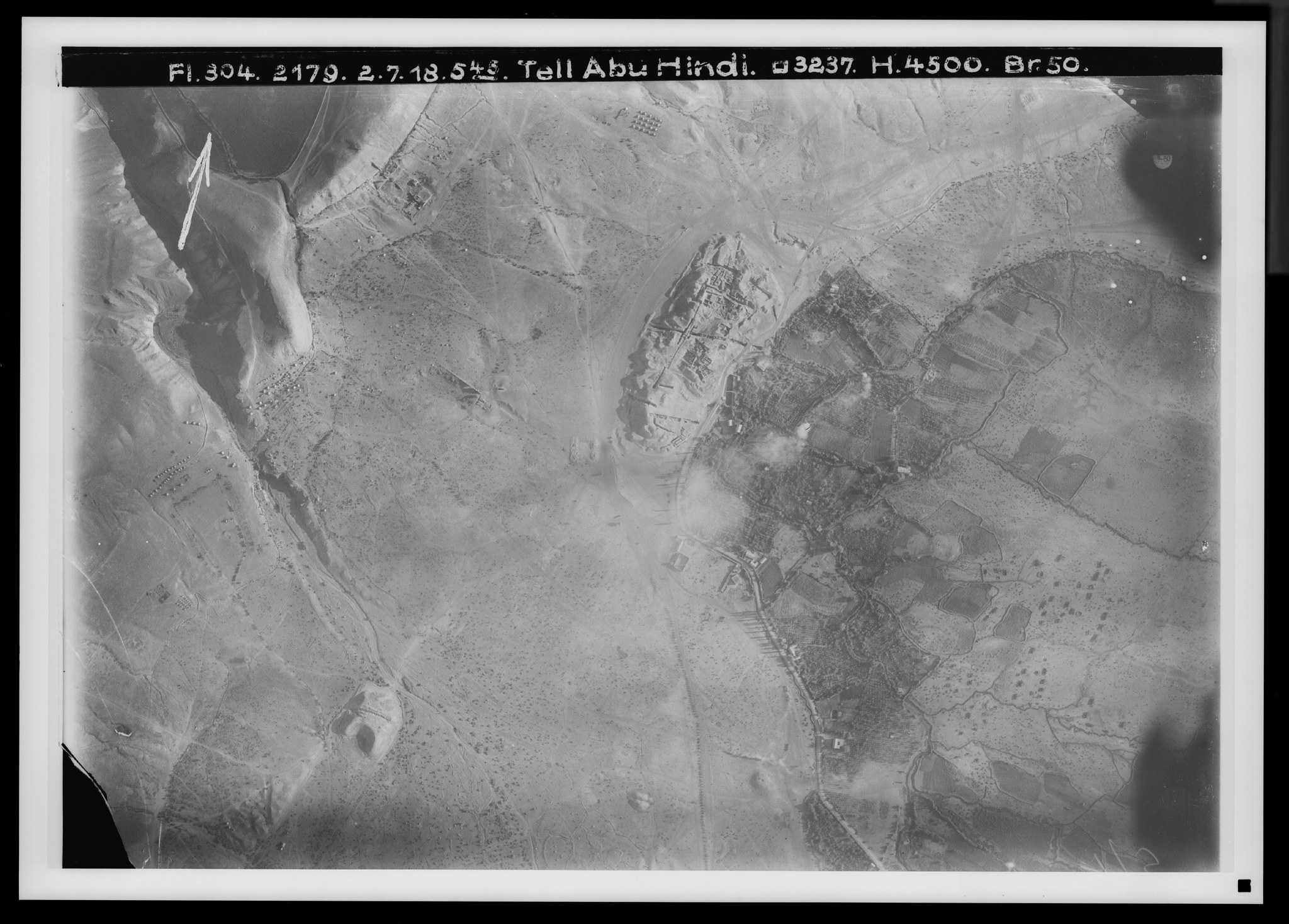
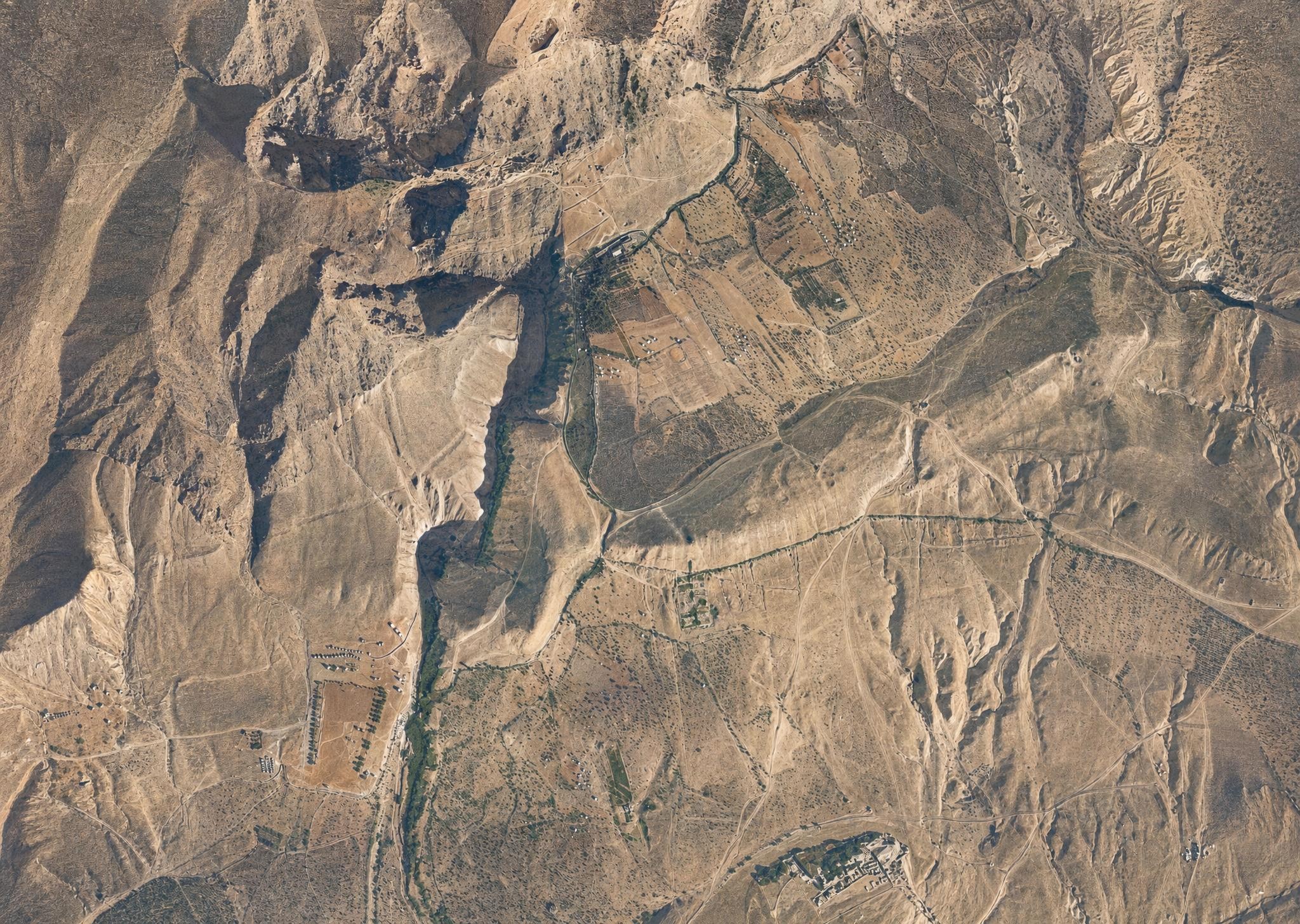
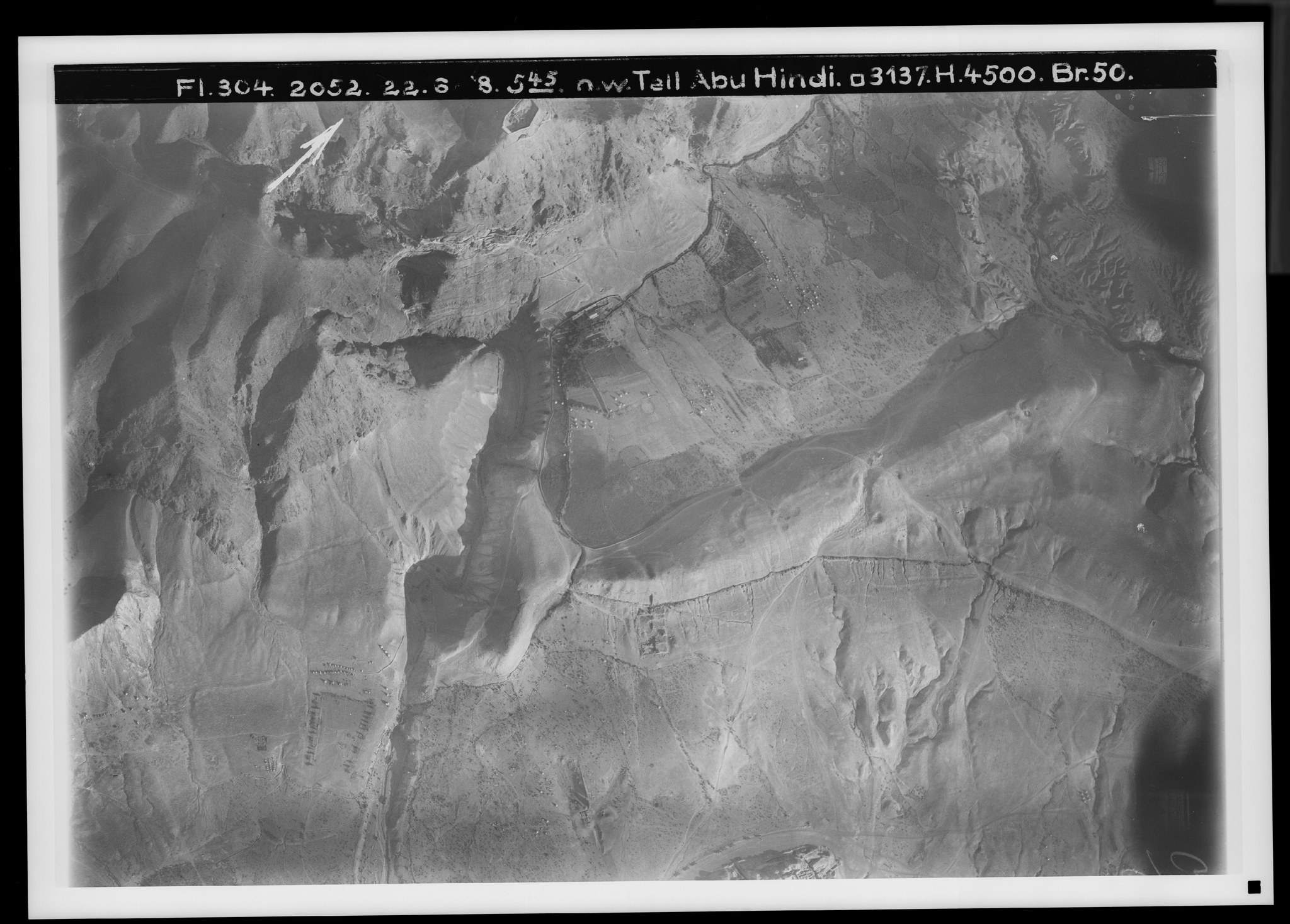
18. Jericho II (the ascent of Adummim). View toward the north. V. 857.
Plate 18. Jericho II (the ascent of Adummim). View toward the north.
FA 304, No. 955. 21 April 1918, 8 a.m.; altitude 4,000 m; focal length 23 cm.
In the middle of the desert, at the boundary of the basins of Wadi es-Sidr (), of Wadi el-Kelt through its side branch Wadi Abu-d-Dba‘ (), and of Wadi Medbah ‘Aijad (), which runs parallel to Wadi el-Kelt. The depression of the first step of the hill country's eastern fall ends here at a height of 196 m, after which, with the climb to 310 m at the castle ruin Kal‘at Tal‘at ed-Damm (), the second step follows.
The carriage road begins here, 6 km beyond its eastern end on No. 17; it first runs along Wadi es-Sidr (), surmounts with switchbacks (on both ascent and descent) at Turret el-Beda the ground swell between it and a tributary (), and then passes over into the depression below the height of Kal‘at ed-Damm, which it crosses at Khan Hatrur, the so-called Inn of the Good Samaritan (), in order now to descend as the Tal‘at ed-Damm — the ascent of Adummim of Josh. 15:7 — ().
The road from ‘Anata–Anathoth joins the carriage-road line at Turret el-Beda (); a road from Jeba‘ over Wadi Fara runs somewhat farther east (). The Kelt spring is reached by way of Wadi Abu-d-Dba‘ ().
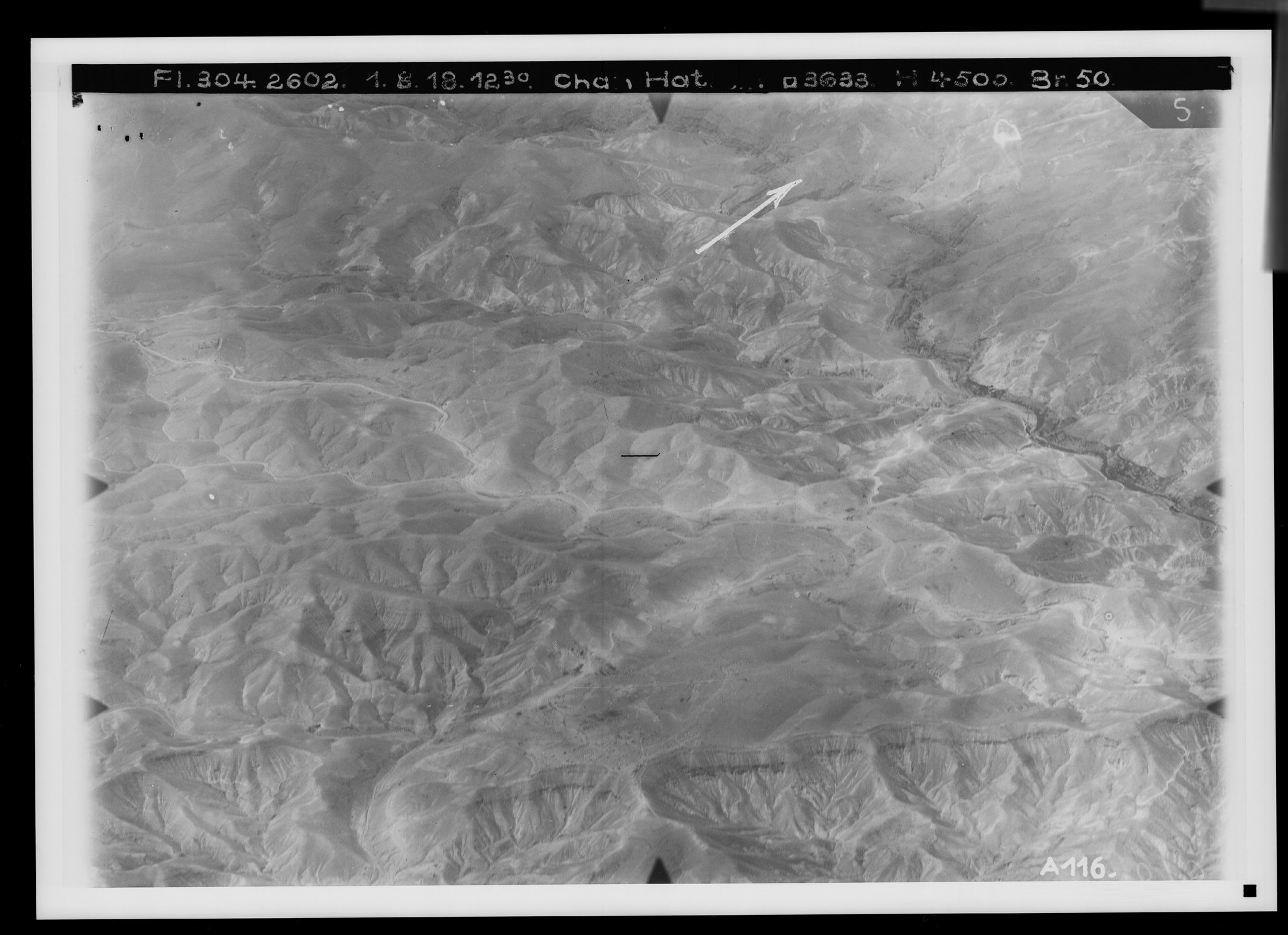
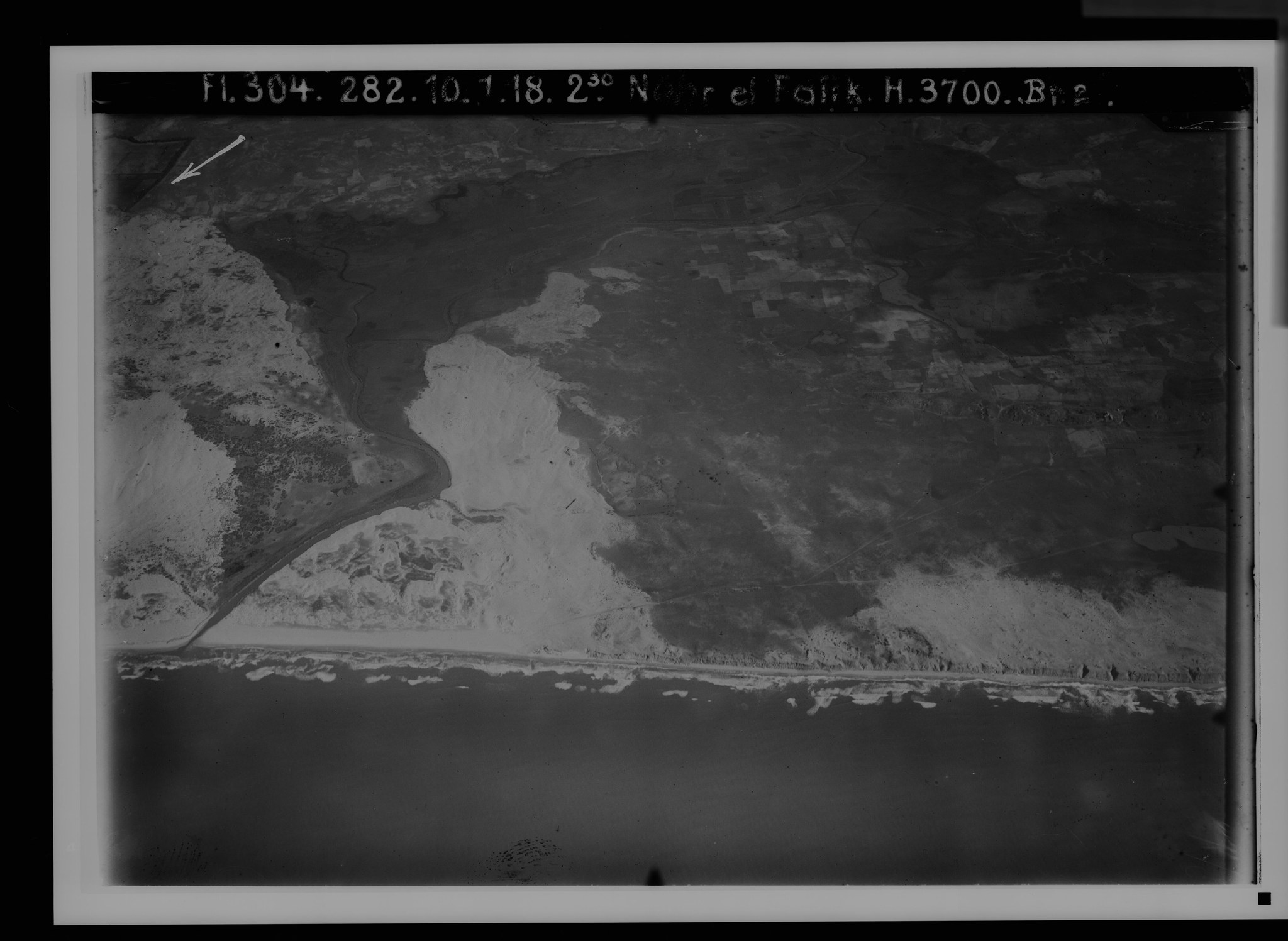
19. The Jericho road III (Wadi el-Kelt). View toward the southeast. V. 862.
Plate 19. The Jericho road III (Wadi el-Kelt). View toward the southeast.
FA 304, No. 2602. 1 August 1918, 12:20 p.m.; altitude 4,500 m; focal length 50 cm.
The road now descends continuously from its height at Khan Hatrur (), 310 m; by the probably still-ruined coffee house Khan el-Meshrab () it is only 131 m high, and at the right edge of the picture (), about 5 km from Jericho, 27 m above sea level. To the north it is accompanied by a higher rim that introduces the fall toward Wadi el-Kelt, which — as the deepest channel of the desert in this region — drains the area east of the watershed from Ras Abu Halawi as far as Betin.
The main valley is visible before the confluence of Wadi Fara (from the left) and Wadi es-Sweinit (from the right) at ; then follow the area of the spring el-Fauwar (), the spring ‘Ain el-Kelt (), and the mill driven by its stream (), below the mouth of the side valley Wadi Abu-d-Dba‘ coming from the southwest (). Above it rises the ridge of ‘Arak Ibrahim (), the watershed between Wadi Fara and Wadi Abu-d-Dba‘.
Through the foreground, as a branch of the main road, runs the so-called Nebi Musa road (), which since 1908 has provided an easier-to-maintain carriage road to Jericho, at the cost of a 6½ km detour to the south. At its heights the desert appears everywhere covered with the youngest limestone strata (nari). Where the fall to the Jordan plain sets in (), erosion has exposed a long band of flint.
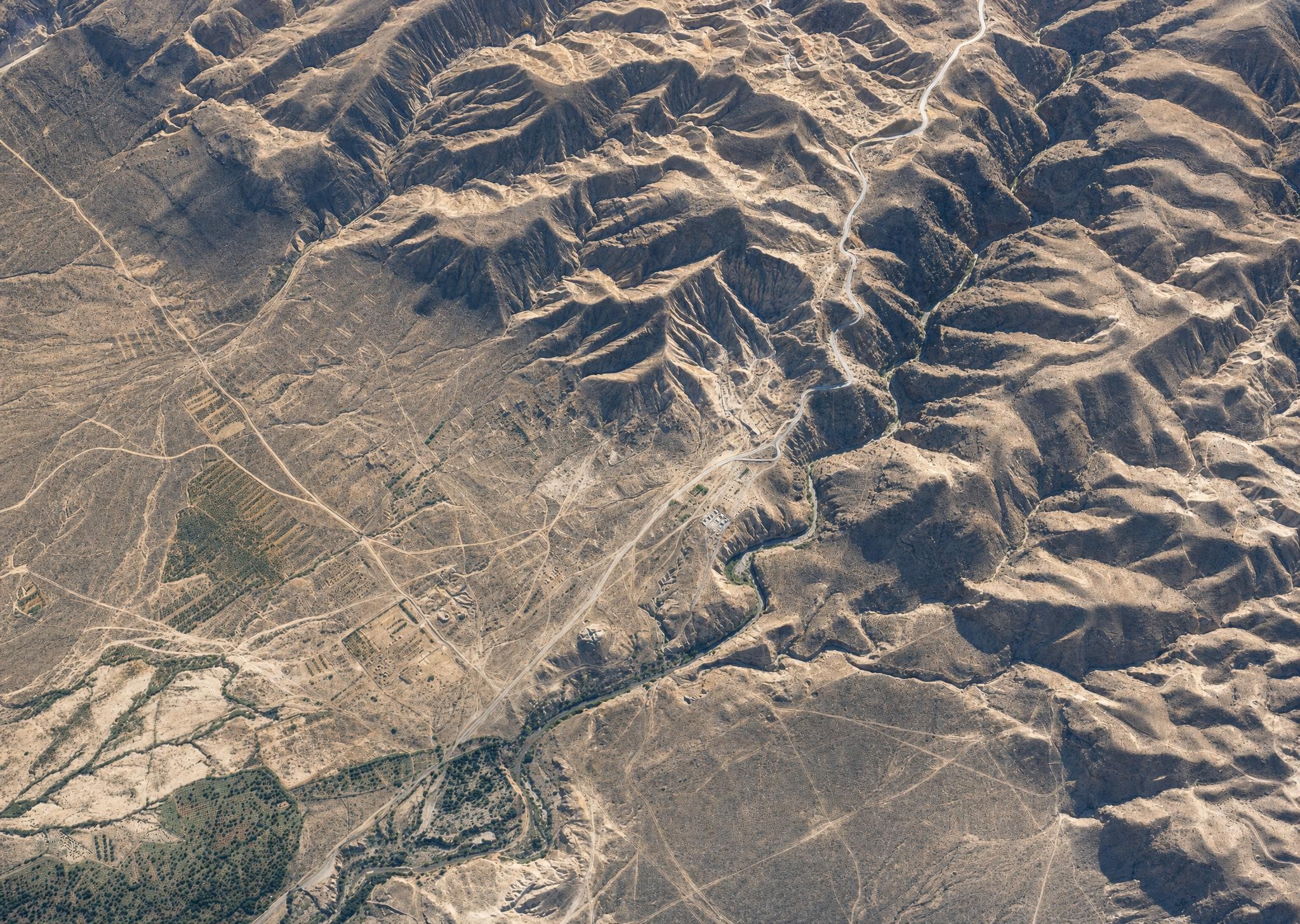
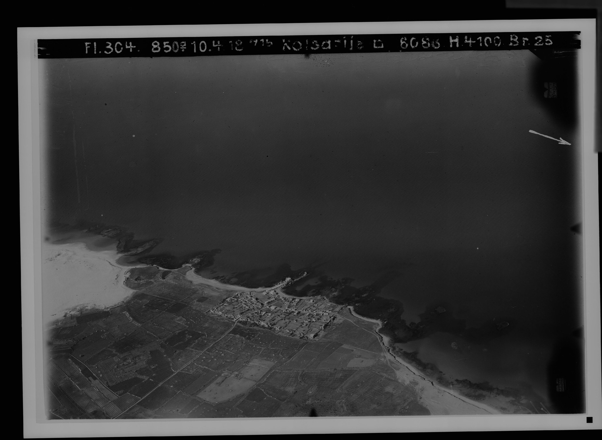
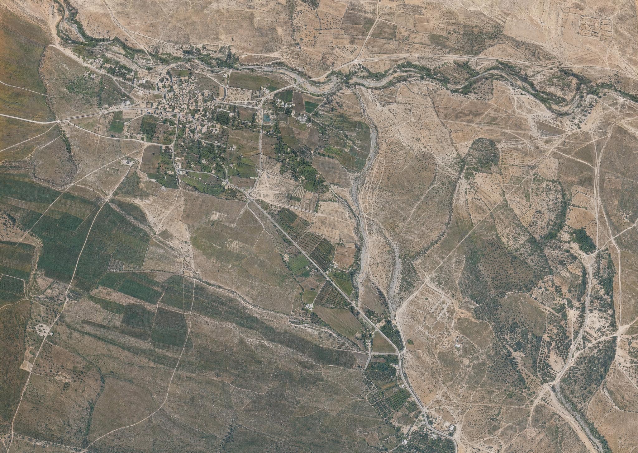
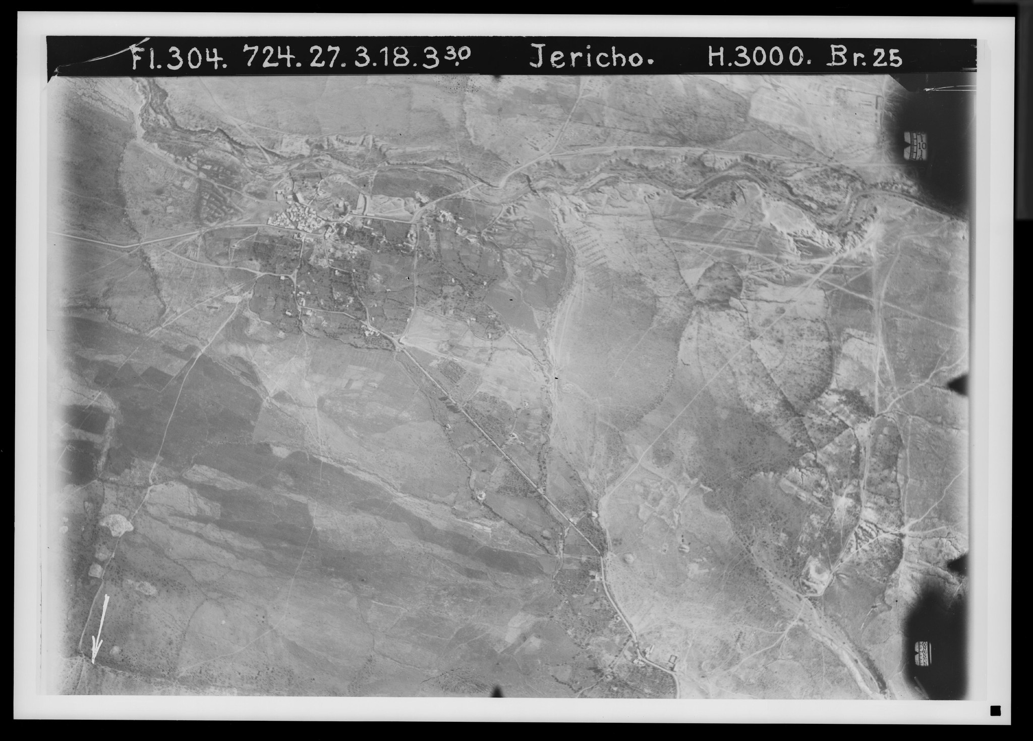
20. The Jericho road IV (descent to the Jordan Valley). View toward the northeast. V. 1042.
Plate 20. The Jericho road IV (descent to the Jordan Valley). View toward the northeast.
FA 304, No. 721. 27 March 1918, 3:30 p.m.; altitude 3,000 m; focal length 25 cm.
The road () now runs, at the fracture line of the Jordan rift, already 27 m below sea level, in the immediate vicinity of the water-bearing Wadi el-Kelt, whose monastery lies beyond the upper edge of the picture; and it finally has, despite two switchbacks (), a very steep descent to about −180 m, while Jericho lies another 70 m lower. An old pack trail straight to the Jordan ford by Wadi el-Kelt runs farther south through Wadi Medbah ‘Aijad (). Parallel to the mountain fall, the great meridional valley-route runs northward ().
A castle ruin is Khirbet Kakun (); an old collecting pool for the water led here from the Kelt spring is Birket Musa (). A northern, waterless tributary of Wadi el-Kelt is Wadi Shuchch ed-Daba‘ (); on the near side of it begins the ascent () to a historically important road toward Betin (see PJB 1913, pp. 26ff.; 1914, p. 17). Military camps and trenches at various places. Not a tree.
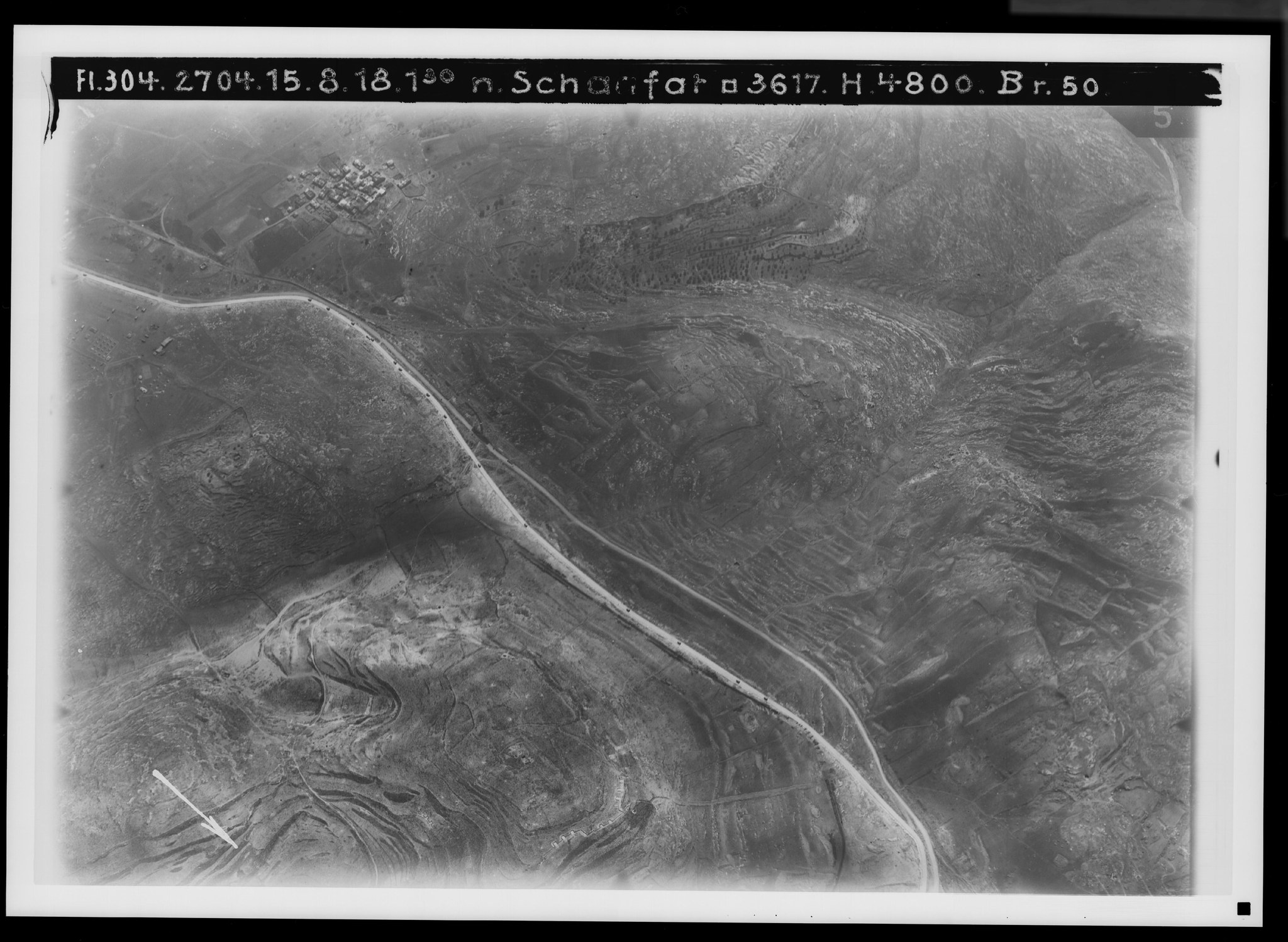
21. The northern road from Jerusalem I (Sho‘fat and Tell el-Ful). View toward the northeast. V. 648.
Plate 21. The northern road from Jerusalem I (Sho‘fat and Tlel el-Ful). View toward the northeast.
FA 304, No. 2704. 15 August 1918, 1:30 p.m.; altitude 4,800 m; focal length 50 cm.
Only a few hundred meters are missing from the picture for the road to connect with No. 14. The older line of the road departs little from the new one. Independent of it is a military field railway (), which soon crosses the road () and then continues on the other side (as far as ).
The watershed follows the heights east of the road. Down to Wadi ed-Damm () runs the two-branched side valley Challet Mesh‘al.
Besides the village of Sho‘fat (), the hill opposite it—occupied by the insignificant ruin Khirbet es-Soma‘ ()—is noteworthy, and still more the hill of Tell el-Ful (), the ruin of the fortress of Saul's Gibeah. At the eastern foot of this hill runs a path from Hezma to Jerusalem (). On the northern road in general see PJB 1925; on Tell el-Ful see Linder, Sauls Gibea (1922), and Albright, Annual IV (1924), pp. 1ff.
22. The northern road from Jerusalem II (Bet Hanina, er-Ram). View toward the east-northeast. V. 642.
Plate 22. The northern road from Jerusalem II (Bet Hanina, er-Ram). View toward the east-northeast.
FA 304, No. 231. 3 January 1918; altitude 3,000 m; focal length 25 cm.
From the road, 2 cm () repeat about 7 cm of No. 21. There then follow stretches with greater deviations of the new line from the straight-running old one, up to the crossing of Wadi en-Nuss (), at which point the old and new lines coincide.
Here too the watershed follows the heights east of the road, from Tlel el-Ful () to the hill of the village er-Ram—Ramah ().
The Beth-horon road coming from Jaffa and Lydda () passes the hill of Khirbet ‘Addase—Adasa () and joins the northern road at Khirbet el-Hawanit (). Less important is the path from the village of Bet Hanina () to the main road () and to the Beth-horon road (), but important is the way from er-Ram () over Kharaib er-Ram, now a quarry, to the Beth-horon road and Gibeon (), with a branch line below er-Ram () from Dscheba—Geba of Benjamin.
— The valley below er-Ram crosses the northern road as Wadi en-Nuss (), then runs as Wadi ed-Damm before the area of Bet Hanina () and empties into Wadi Bet Hanina (), coming from ed-Dschib—Gibeon, the great water artery of the terrain west of the watershed, here visible at the upper edge of the picture from the area of Bir Nebala () onward. Terraces on the slopes and fields on the flats show the cultivation of the land.
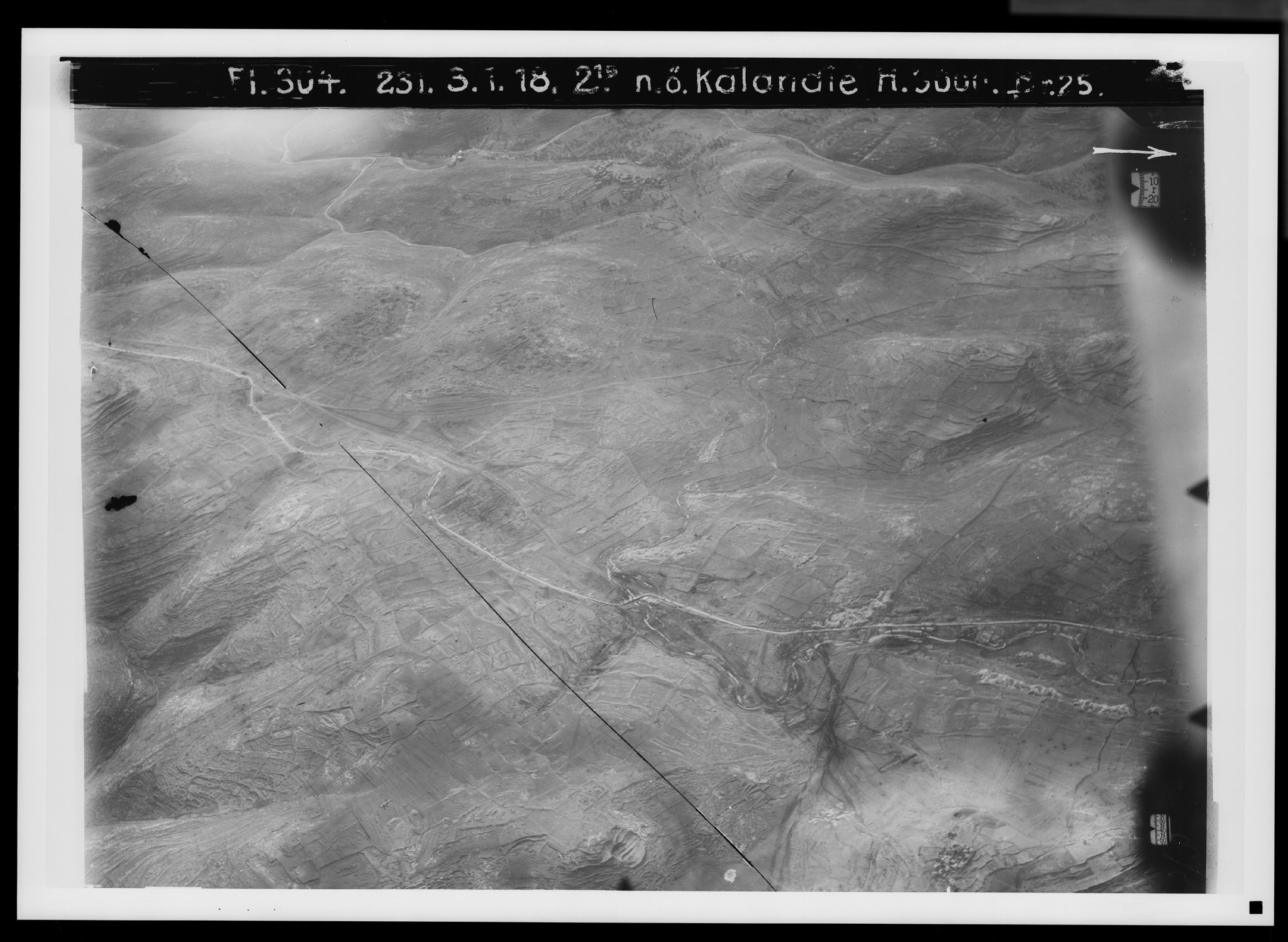
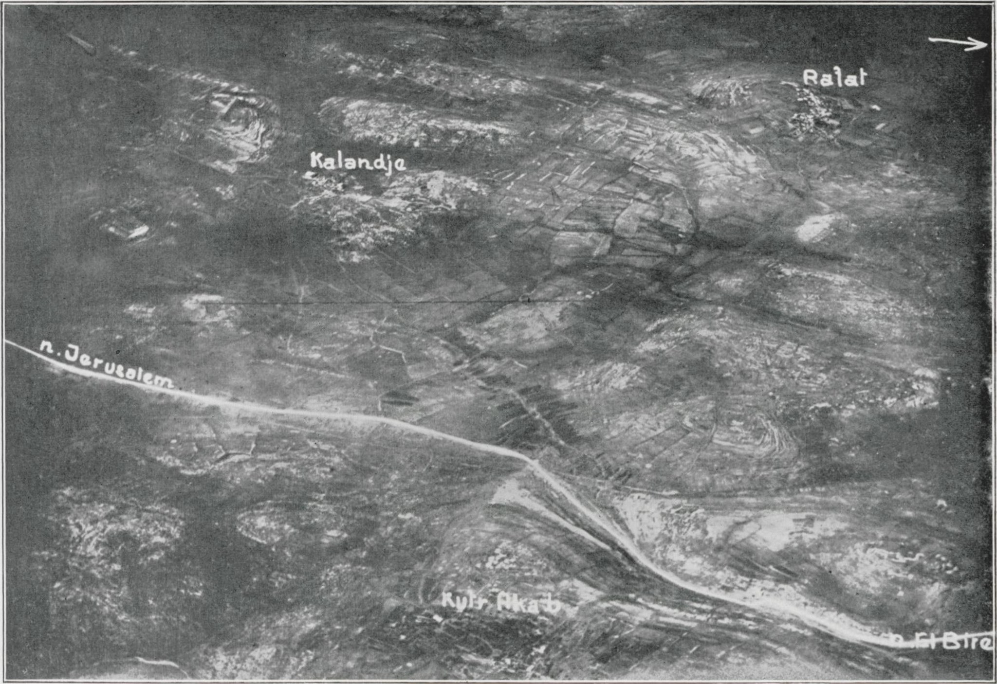
23. The northern road from Jerusalem III (Kalandie, Kufr ‘Akab, Rafat). View toward the east. RA.
Plate 23. The northern road from Jerusalem III (Kalandie, Kufr ‘Akab, Rafat). View toward the east.
FA 301, No. 908. 15 April 1918, 8 a.m.; altitude 4,200 m; focal length 50 cm.
Only about 2 cm are missing for the connection with No. 22. The valley channel of the upper course of Wadi en-Nuss veers off westward in the plain of el-Bak‘a (), while the road runs straight on until, at Khirbet ‘Attara—Ataroth-addar (), it rejoins the valley and now passes Tell en-Nasbe () in Wadi Dschiljan.
Present-day settlements are, in the east, Kufr ‘Akab (, not at the name), and in the west, Kalandie (), Dschedire () and Rafat (), the last two in the area of the parallel valley Wadi Bir ed-Der (), the upper course of Wadi Bet Hanina.
The valley on the near side of the carriage road (), with its branches above, belongs to Wadi en-Natuf, a side valley of Wadi es-Swenit, and thus to the catchment of the Jordan.
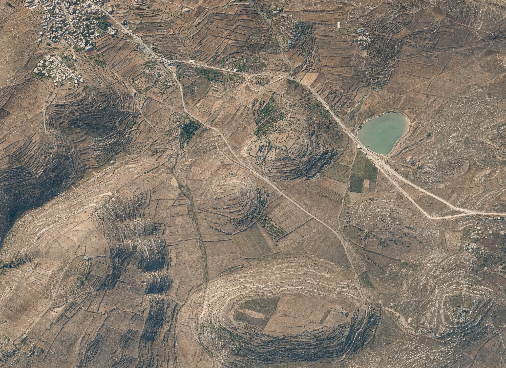
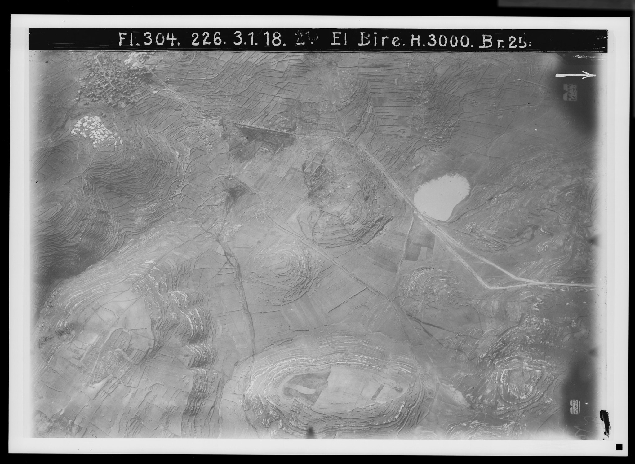
24. The northern road from Jerusalem IV (Tell en-Nasbe). View toward the east. V. 595.
Plate 24. The northern road from Jerusalem IV (Tell en-Nasbe). View toward the east.
FA 304, No. 224. 3 January 1918, 2:15 p.m.; altitude 3,000 m; focal length 25 cm.
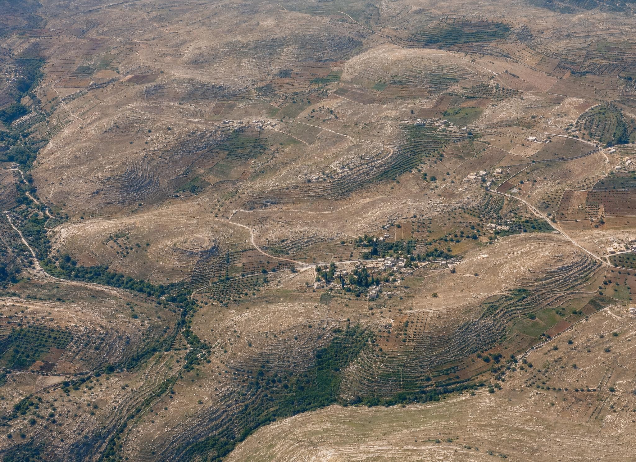
The road (5½ cm here = 8 cm on No. 3), less distinct, begins at Khirbet ‘Attara—Ataroth-addar (), passes the spring ‘En en-Nasbe () and the ancient settlement site of Tell en-Nasbe, probably Mizpah (), and reaches as far as near the spring of el-Bire ().
To the system of Wadi ed-Damm belong Wadi Dschiljan (), in which the road runs, and the parallel Wadi Duwet to the west (according to the English map) (), with a path from Ramallah to the carriage road ().
The path from el-Bire to Rafat () is important as a connection to the Beth-horon road at el-Latatin. As the upper course of Wadi Bet Hanina may be reckoned the Wadi Bir ed-Der lying still farther west (), which the path from Ramallah to ed-Dschib—Gibeon follows.
To the eastern drainage of the country belongs Wadi el-‘En (), coming from el-Bire, a tributary of Wadi es-Swenit.
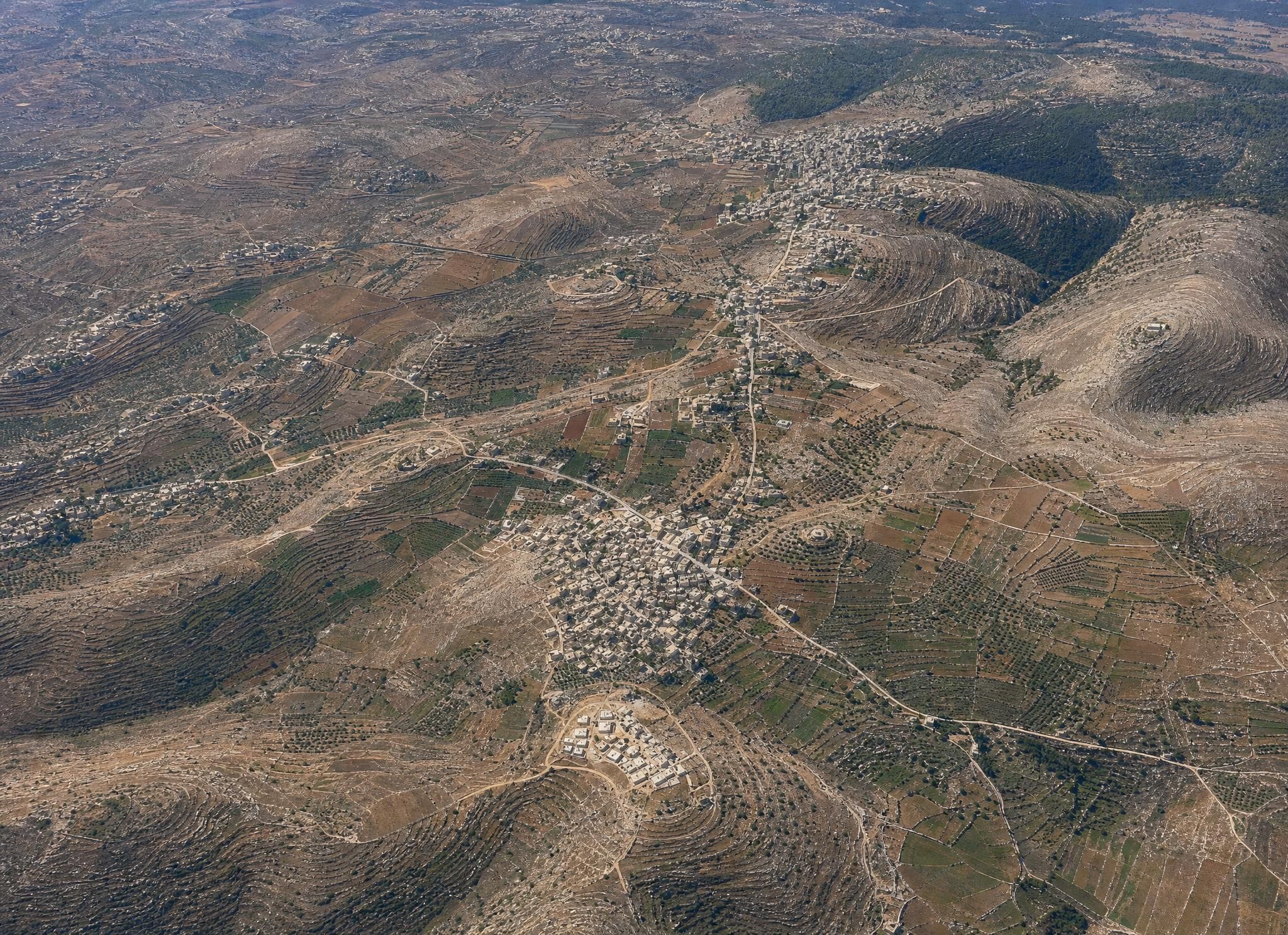
25. The northern road from Jerusalem V (el-Bire, Ramallah). View toward the northeast. V. 596.
Plate 25. The northern road from Jerusalem V (el-Bire, Ramallah). View toward the northeast.
FA 304, No. 225. 3 January 1918, 2:15 p.m.; altitude 3,000 m; focal length 25 cm.
From No. 24, 9 cm on the right are repeated here on the left as 7½ cm. The northern road coming from Wadi Dschiljan crosses the height of the watershed () and passes between the village of el-Bire (), 810 m, and the Ras et-Tahune (), 893 m, over into the region of valleys belonging to the eastern slope of the country (Wadi es-Swenit), while the watershed continues to the west.
The Dschebel et-Tawil (), though at 910 m the highest point of the area, lies on the near side of the watershed.
The northern road continues from as a carriage road in a northerly direction (). A second branch, which was probably the oldest northern road, turns from to the northeast () in the direction of Betin—Bethel ().
West of el-Bire lies Ramallah (), 869 m, connected to it and to the northern road (at ) by a road, above the Wadi el-Merara () skirting it to the north, belonging to the system of the Nahr el-‘Odscha. There is, however, also a path running northward along the watershed between Ramallah and el-Bire (), whose nearest destinations must be taken to be Surda and Dschifna—Gophna, but which also ties in further connections to the northwest.
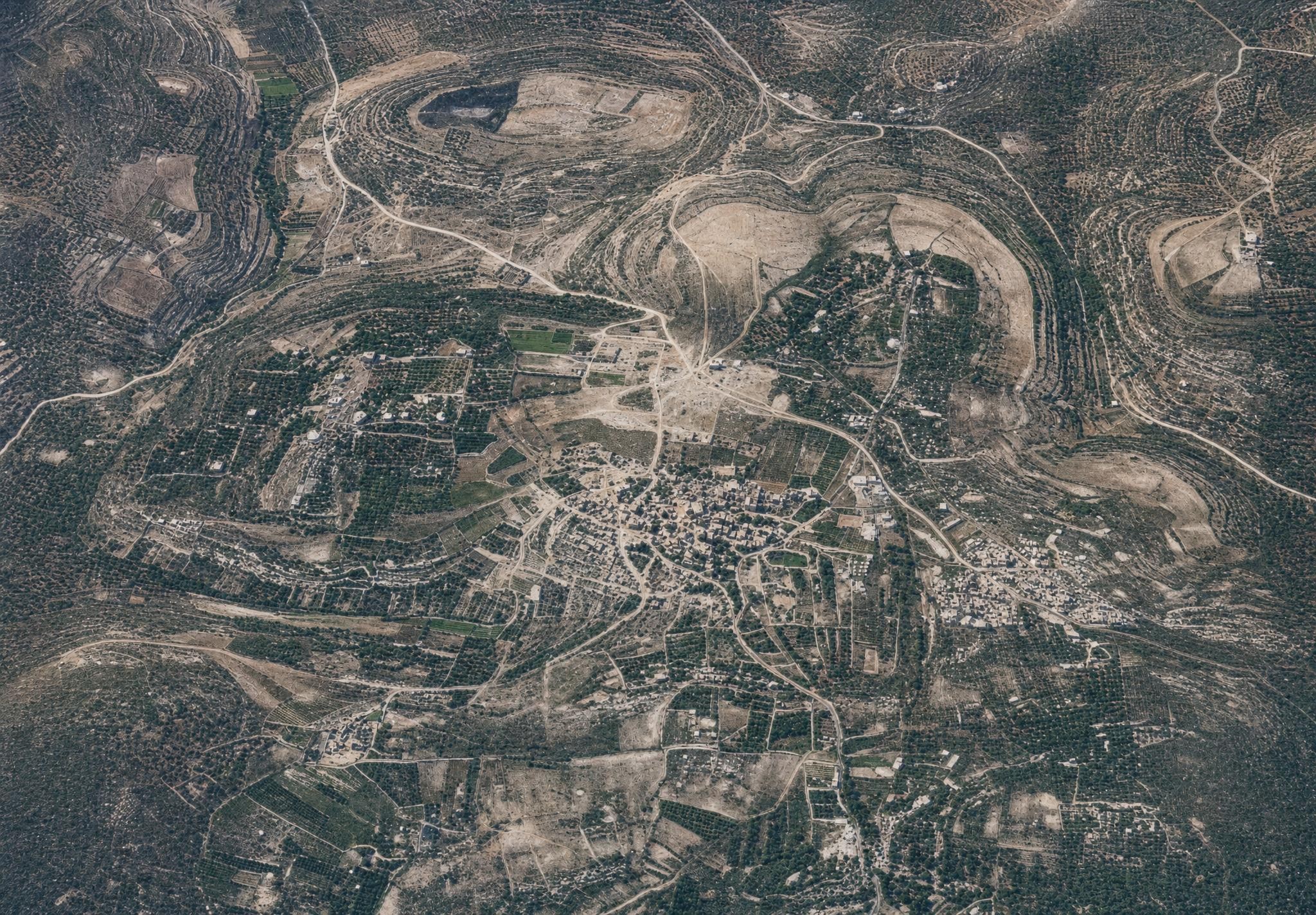
26. The northern road from Jerusalem VI (the road to Bethel). View toward the east. V. 597.
Plate 26. The northern road from Jerusalem VI (the road to Bethel). View toward the east.
FA 304, No. 226. 3 January 1918, 2:15 p.m.; altitude 3,000 m; focal length 25 cm.
About 10 cm to the right of No. 25 equal 9 cm to the left of No. 26. The northern road, remaining always east of the watershed, here passes the great winter water-pond el-Balu‘ (), which forms a basin without outflow but nevertheless stands in connection with a valley running off to the east () that, like the more southerly Wadi ed-Dscherar (), belongs to the system of Wadi es-Swenit.
The pond lies 834 m high and proves that it, and with it the road, lies not much lower than the height reached at el-Bire.
The old northern path leading past Betin—Bethel is visible only as far as the area of ‘En el-Kas‘a (). The path running closer to the carriage road toward the southeast () has the village of ‘En Ebrud as its nearest goal and from there makes possible a connection to the line of the carriage road, but also leads past ‘En Ebrud back to the old northern path. — The village of el-Bire appears again at the upper left (), beside it the white rock surfaces of its threshing floors ().
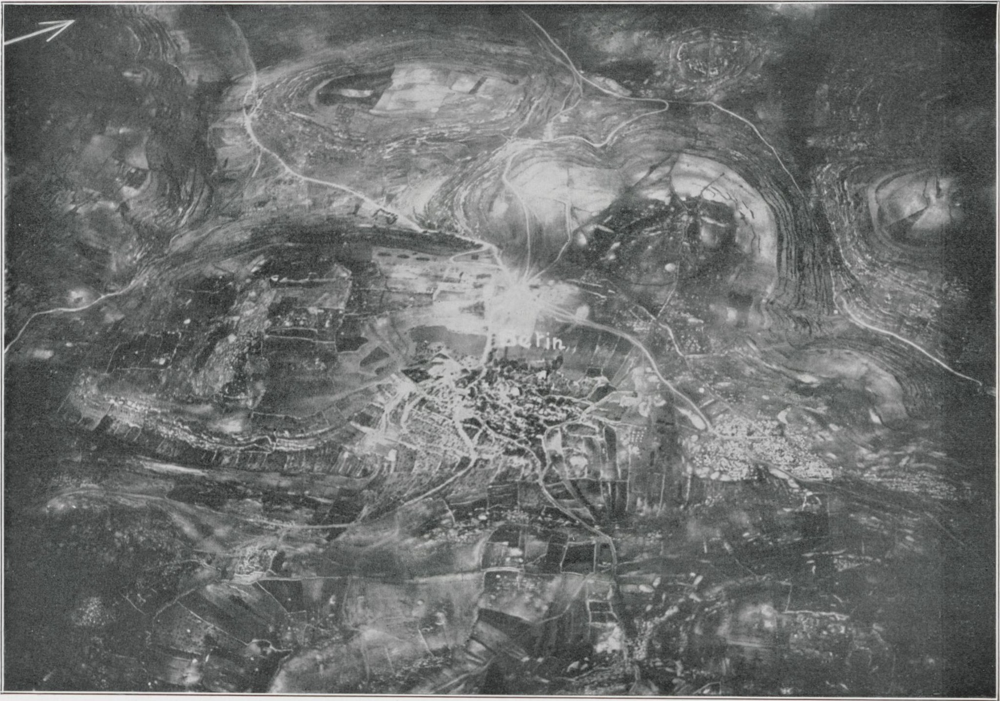
27. The northern road from Jerusalem VII (Bethel—Betin). View toward the east. RA.
Plate 27. The northern road from Jerusalem VII (Bethel—Betin). View toward the east.
FA 301, No. 909. 15 April 1918, 8 a.m.; altitude 4,200 m; focal length 50 cm.
This picture repeats, in 2½ cm of its upper part, about 3½ cm of the lowest part of No. 26. The watershed of the country, which skirts the pond el-Balu‘ (No. 26) on the west, then turns immediately eastward, crosses over to the north side of the height on whose south ‘En el-Kas‘a lies (), and then follows the ridge between two valleys, on which the old northern road of the country () continues.
To the west, Wadi el-Masajat () runs northward, but then turns west toward the system of Wadi Der Ballut and the Nahr el-‘Odscha. In the east, Wadi el-Mesil () runs southward, then joins Wadi ‘Abbas (), which comes from the watershed, and unites with the system of Wadi es-Swenit, which belongs to the catchment of the Jordan.
Between the two valleys, separated from the watershed by a hollow running down to Wadi el-Mesil, lies—881 m high—Betin (), once Bethel, on a low elevation; to its south a pond () with the spring of the place, and to the north a group of natural rock ledges, el-Kal‘at (), which has sometimes been identified as its ancient sanctuary.
For the location of Bethel it was important that near it an eastern road leading to Jericho branches off from the meridional road of the country. It crosses Wadi el-Mesil in a southeasterly direction and then turns more to the east (). In doing so it skirts Burdsch Betin () with the ruins of a church, the presumed site of the ancient sanctuary which, according to Genesis 12:8 and 13:3, lay east of Bethel.
Of local importance is the path to Burka (). Important, however, is the way through Wadi el-Masajat (), later passing ‘En Ebrud, which may be described as a parallel line to the northern road and rejoins it 5 km north of Betin. Cf. Sternberg, ZDPV 1915, pp. 1ff. (see also No. 26).
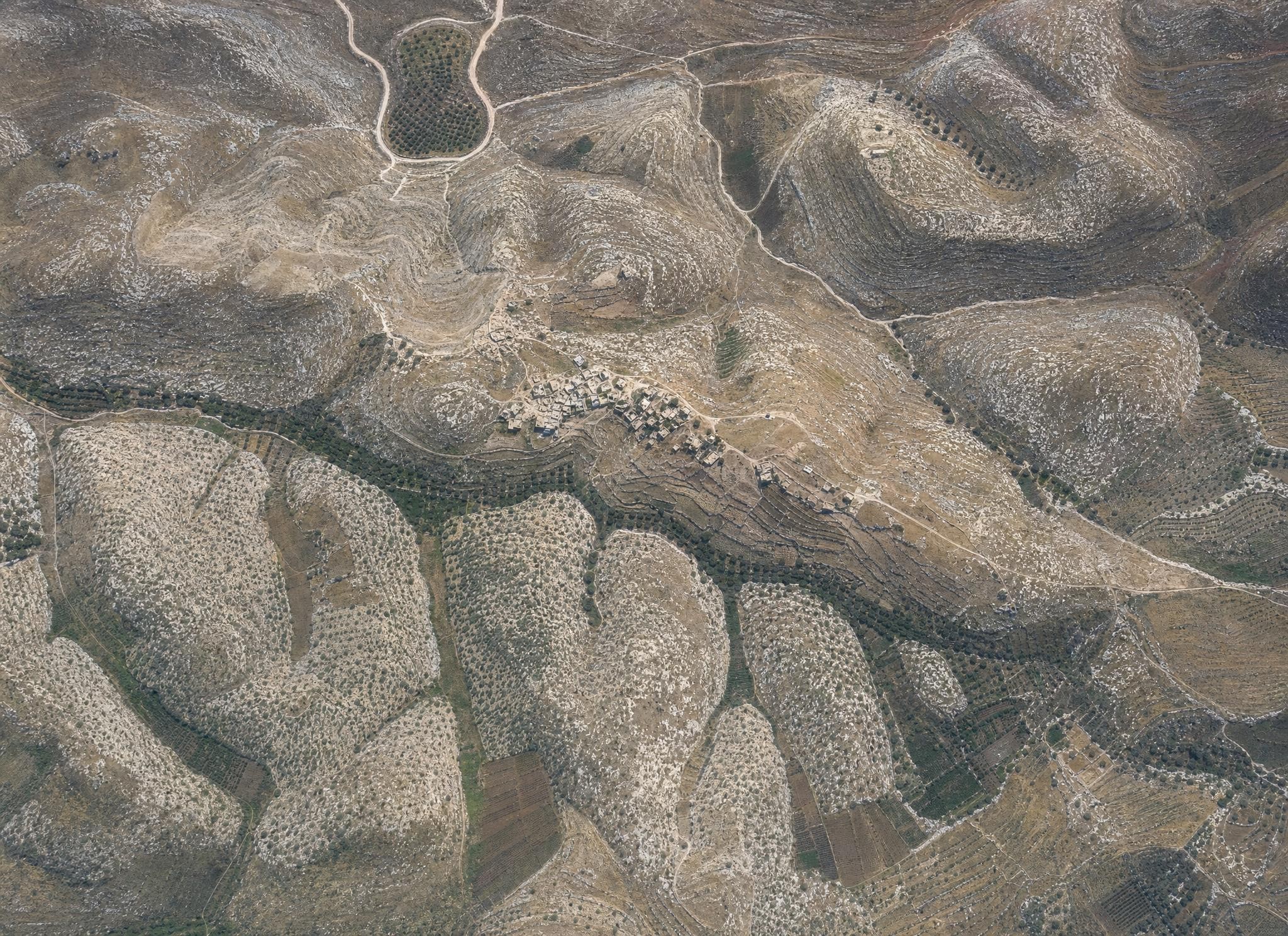
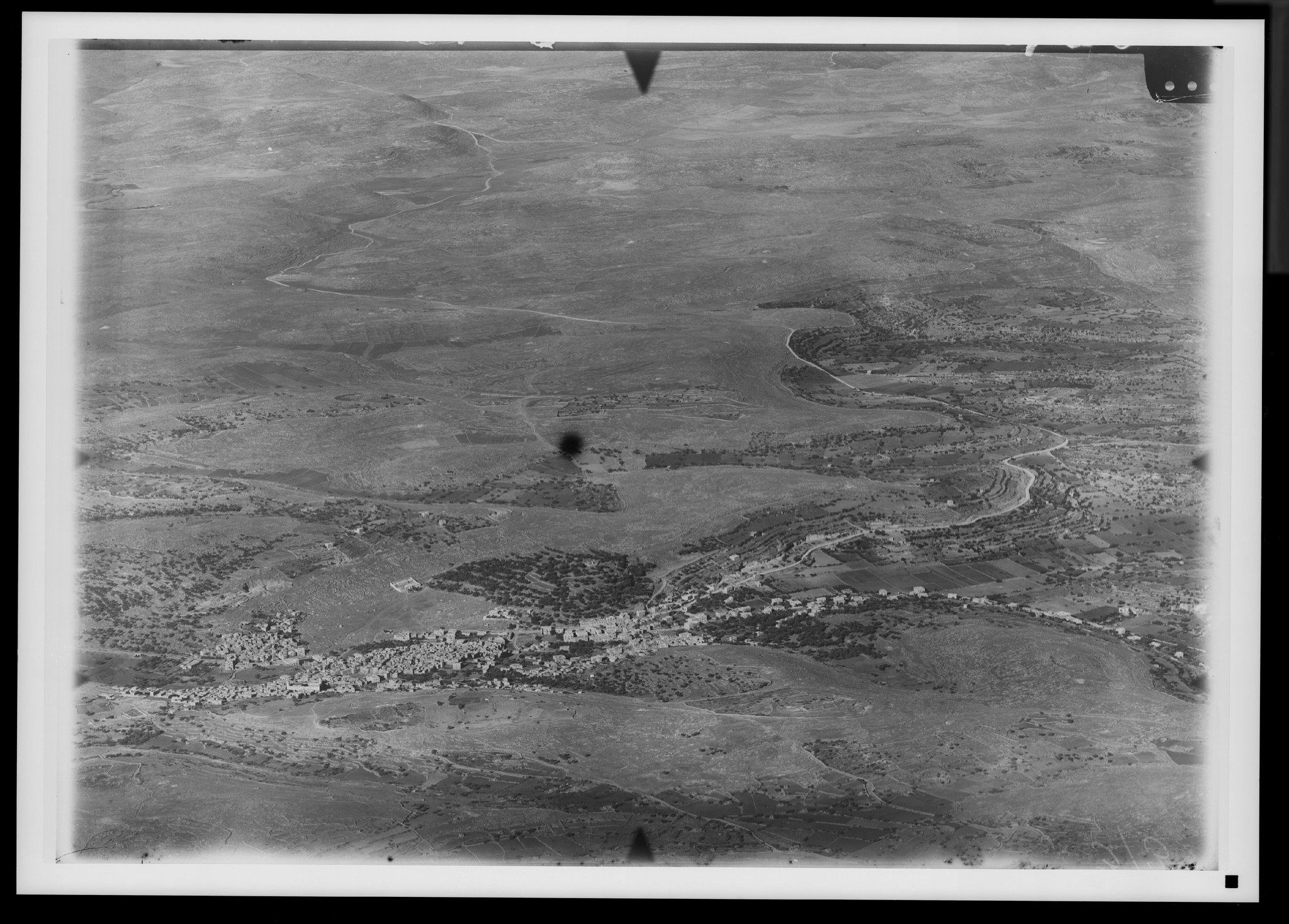
28. Michmash and Wadi es-Swenit. View toward the northeast. V. 638.
Plate 28. Michmash and Wadi es-Swenit. View toward the northeast.
FA 304, No. 221. 3 January 1918, 2:15 p.m.; altitude 3,000 m; focal length 21 cm.
The village of Muchmas (), biblical Michmash, lies 607 m high on the eastern slope of the Judaean country above the deeply incised Wadi es-Swenit, which belongs to the catchment of the Jordan. Of this valley only a small loop is visible (). A side branch descending from the height, Wadi et-Tin (), determines its position from the south, and Wadi ez-Zetun () with the village's olives from the north—a position on a ridge that is connected with higher ground only in the northwest.
Here too lies its natural connection toward the ridge of the country in the direction of Betin—Bethel, the path recognizable from to .
A northern connection leads past Tell el-‘Askar () toward Rammun. To the southwest there is no lack of a path toward er-Ram ().
In a southerly direction the depth of Wadi es-Swenit must be crossed in order to reach, first, Dscheba. The main path (not recognizable) crosses the valley at the mouth of Wadi et-Tin (); a second path runs together with the path to er-Ram farther west, but then turns southward. On this see ZDPV 1904, pp. 161ff.; 1905, pp. 161ff.; PJB 1916, p. 48f.
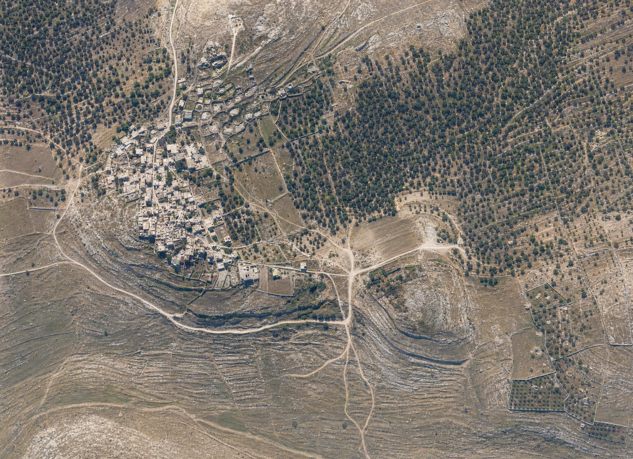
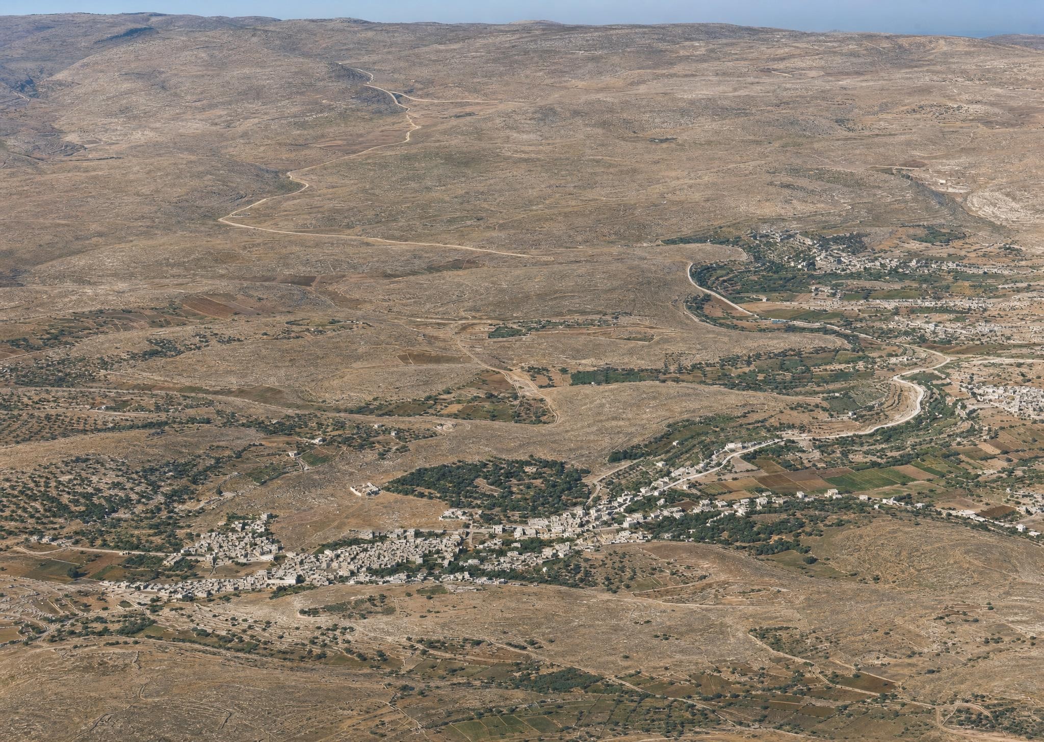
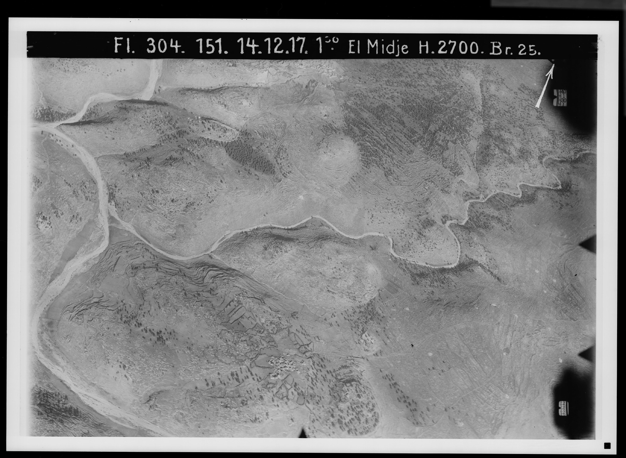
29. Ephron-Ephraim-et-Taijibe. View toward the west. V. 581.
Plate 29. Ephron-Ephraim-et-Taijibe. View toward the west.
FA 304, No. 1753. 5 June 1918, 7:30 a.m.; altitude 4,800 m; focal length 50 cm.
With the high mountain range of Baal Hazor (el-‘Asur), not visible here, as its backdrop, the Christian village of et-Taijibe—once Ephron and Ephraim—thrones, visible from afar but off the great traffic routes, on its knoll (869 m). In this picture it appears by itself, surrounded north and south by great olive plantations that, on the south, fill Wadi Abul-Haijat (). Its own height is the northern termination of a chain of heights that begins at Rammun and has its most prominent summit south of et-Taijibe in the Ras ez-Zemera ().
A particular hill in the east, beyond the village's threshing ground, bears the ruin of a three-aisled church (), called el-Chadr, which commemorates Jesus' stay in Ephraim (John 11:54).
Past it a path leads to the south (), at first toward Rammun, continuing northward toward Der Edschrir and Kufr Malik (). The connection to the northern road of Jerusalem is represented by a path to the west (), and a path to the southeast () by the descent to Jericho.
See Orte und Wege (3rd ed.), pp. 231ff., PJB 1925; cf. Albright, Annual IV, pp. 124ff.
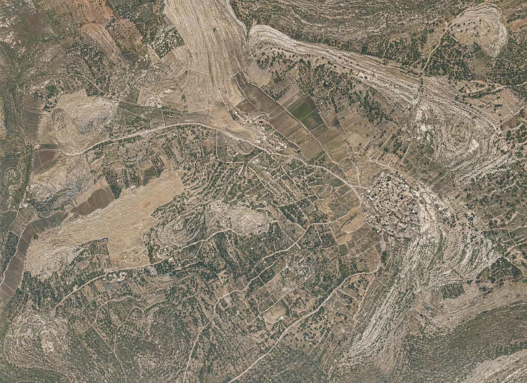
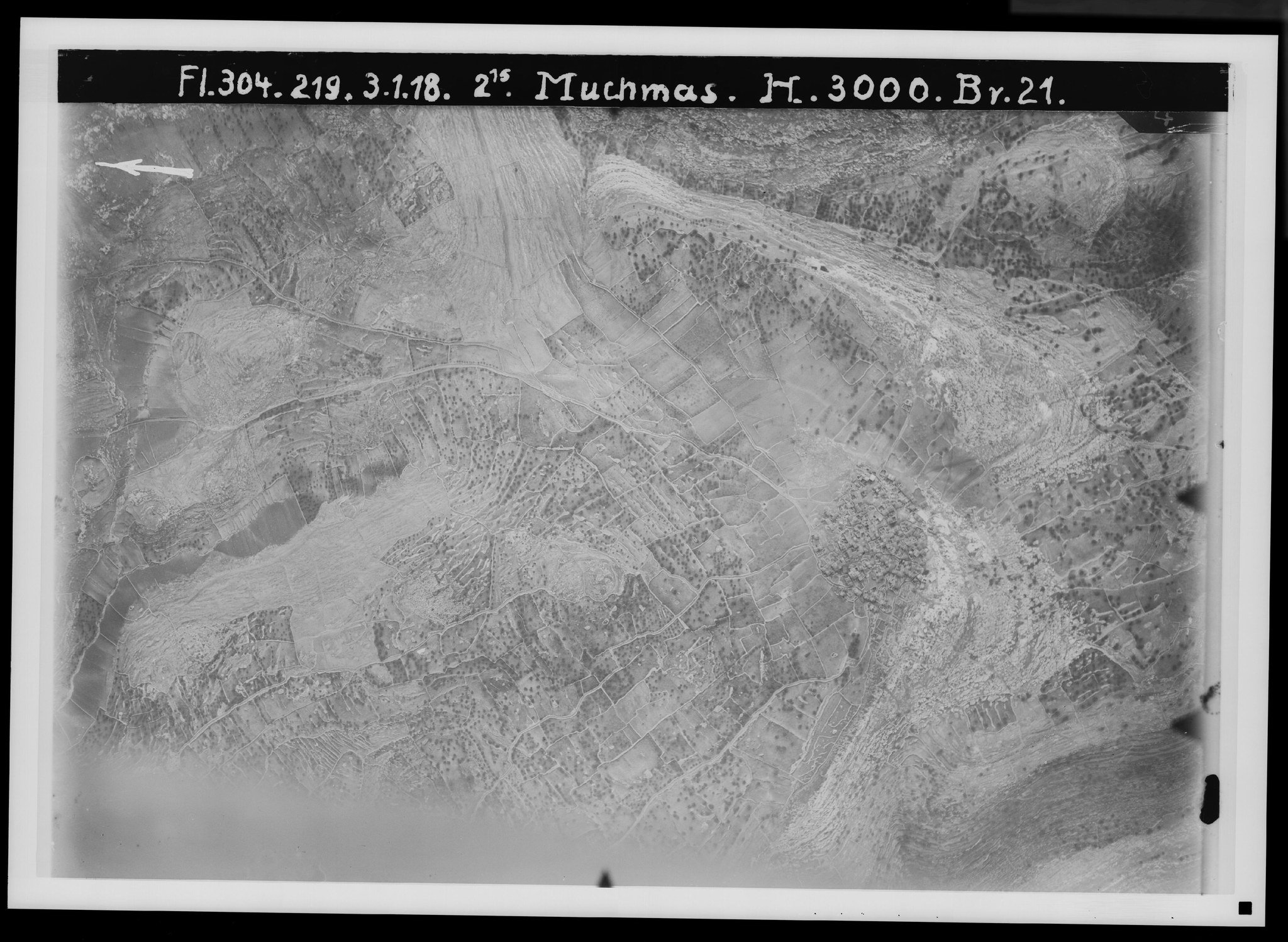
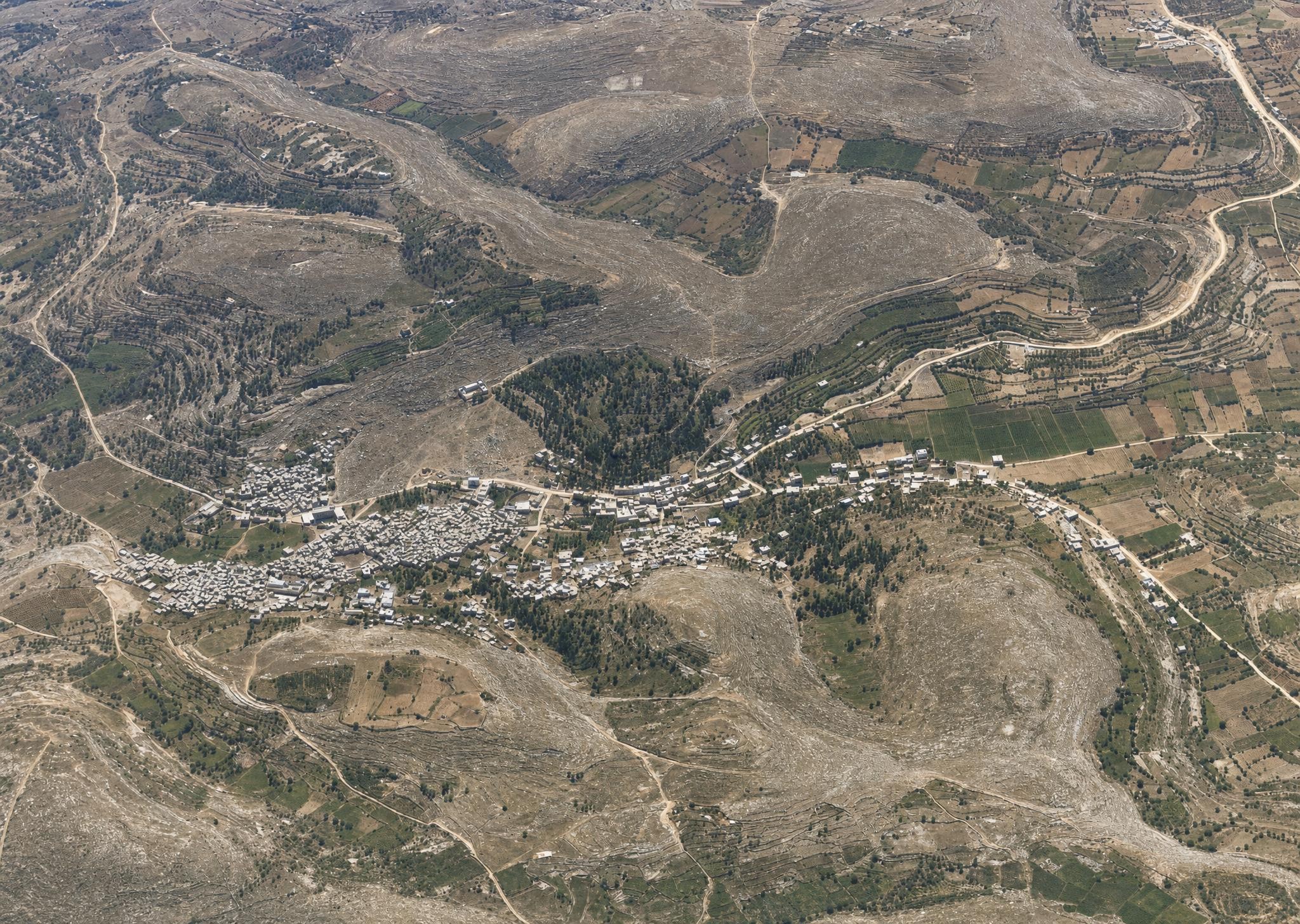
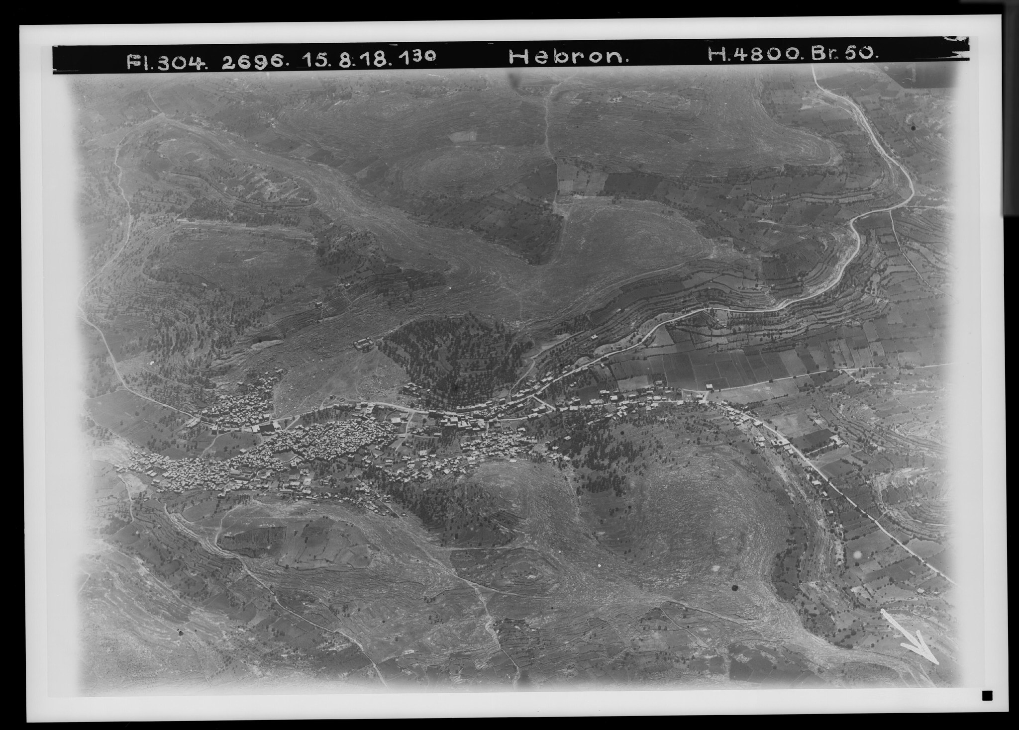
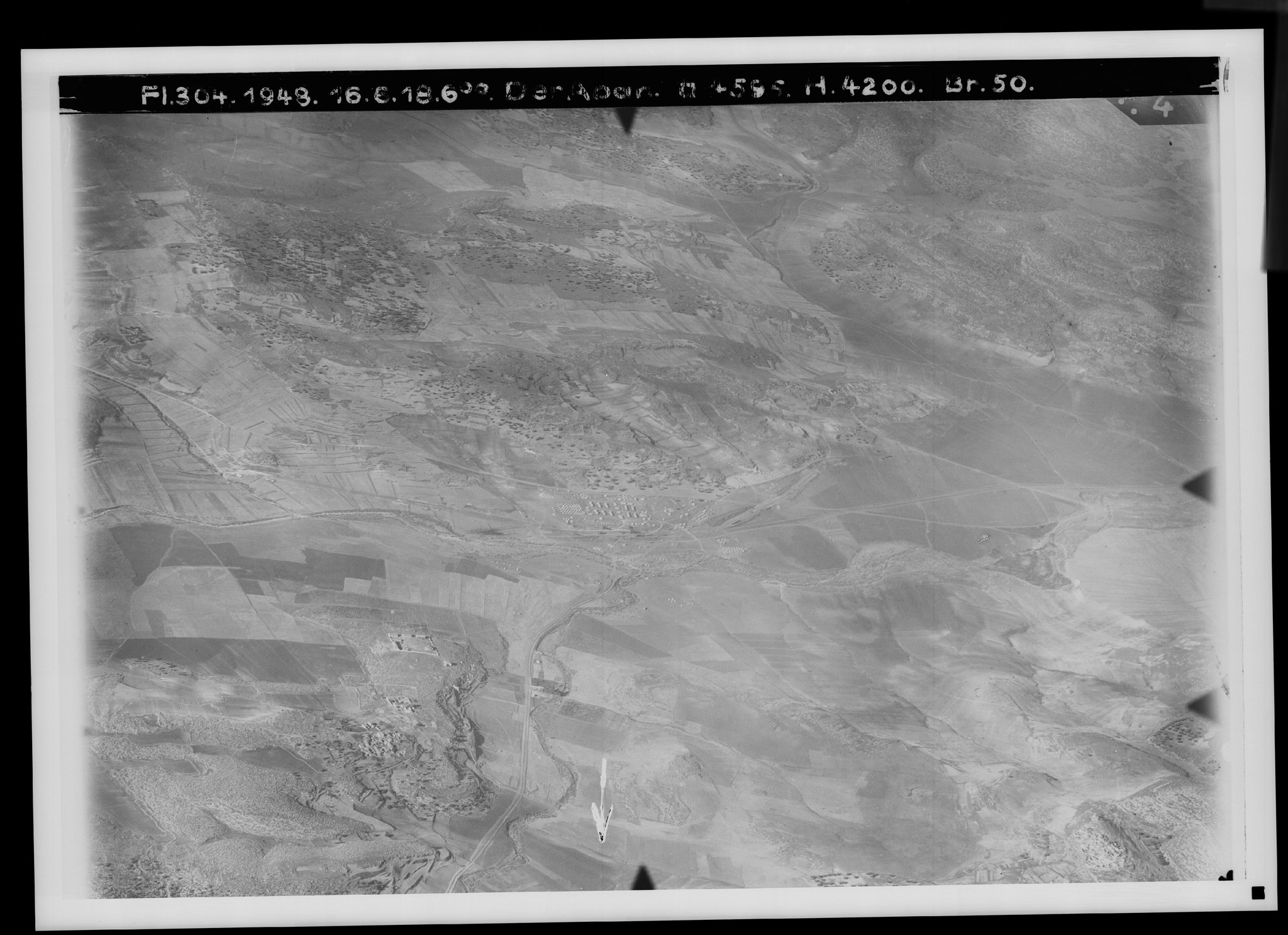
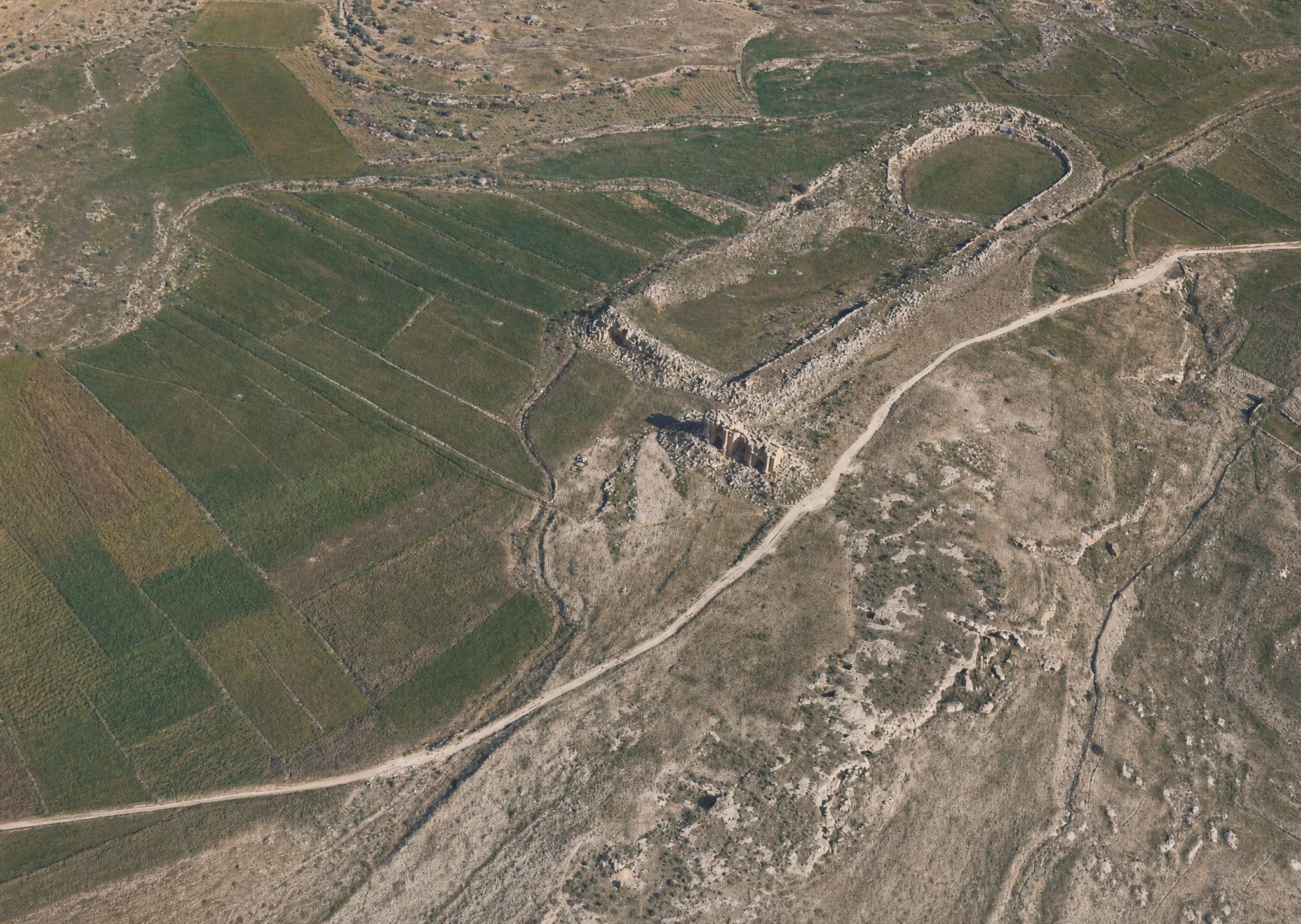
29a. The Rock of Rimmon, Rammun. View toward the west. V. 636.
Plate 29a. The Rock of Rimmon, Rammun. View toward the west.
FA 304, No. 219. 3 January 1918, 2:15 p.m.; altitude 3,000 m; focal length 21 cm.
The image, labeled as Mukhmas, was identified — with the agreement of Professor Albright — as Rammun, which lies 3 km south of et-Taijibe (No. 29) on the road to Mukhmas. It appears to occur as the “Rock of Rimmon” in Judges 20:45 and 21:13, and is recorded as Remmon by Eusebius and on the Madaba map.
The settlement lies at 762 m on a rocky height between the valleys Wadi ed-Dschami‘ (to the west) and Wadi Abu el-Hayat (to the east), both of which run south into Wadi et-Taff, which belongs to the system of Wadi en-Nue‘me (images 72 and 80).
Below the village () lies a large cave (Shqaf Daher) with a collapsed roof, which one might imagine as the refuge of the Benjaminites in Judges 20–21 (), and a rock tomb with the shrine of Sheikh Dschildschal ().
The road to et-Taijibe runs ; the road to Mukhmas, .
B. Judean hill and coastal country.
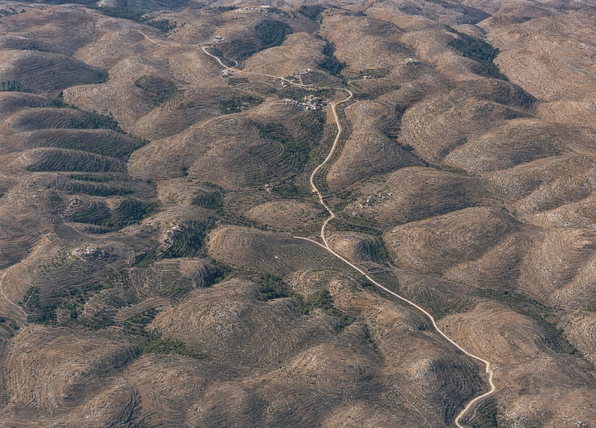
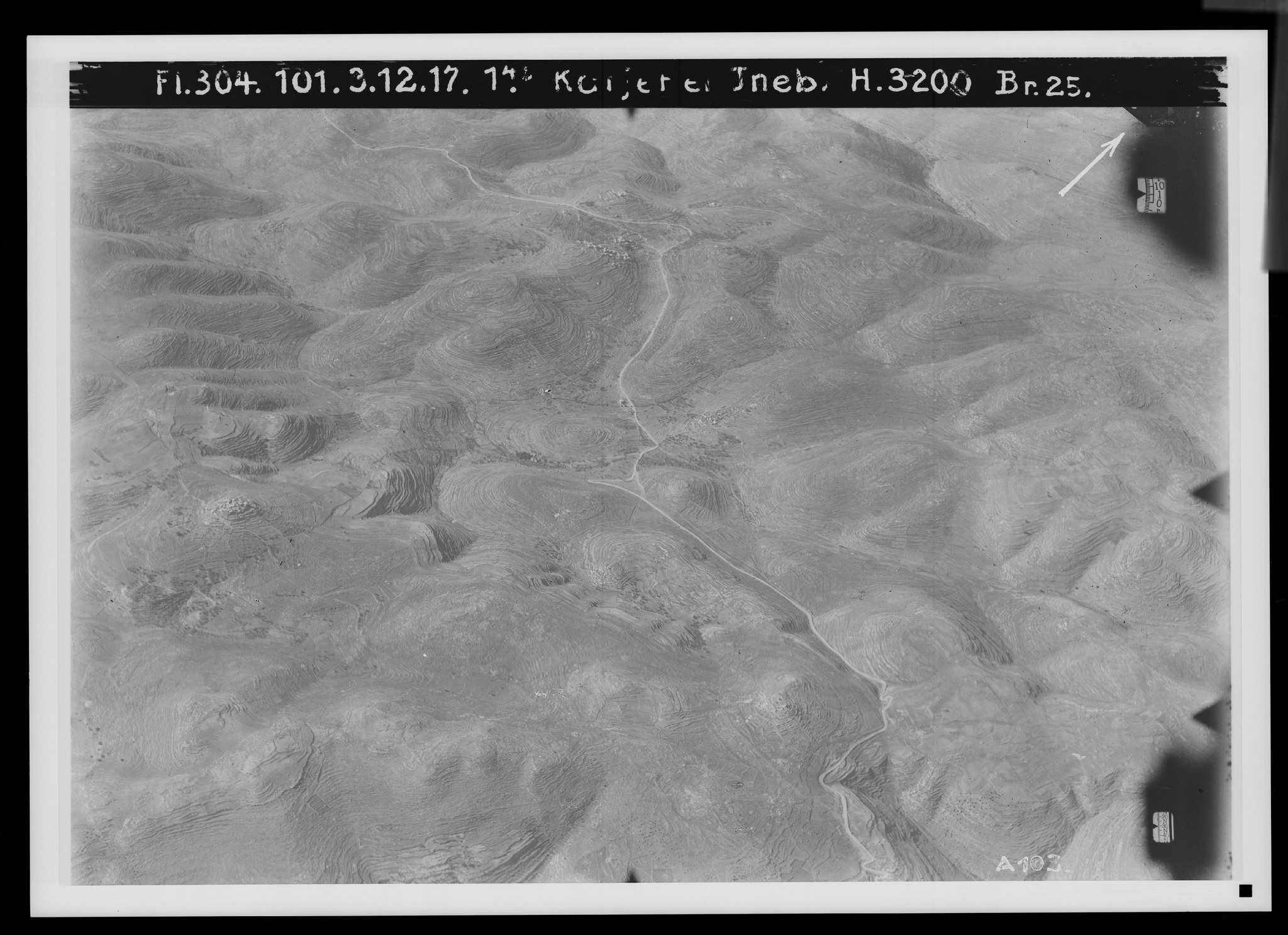
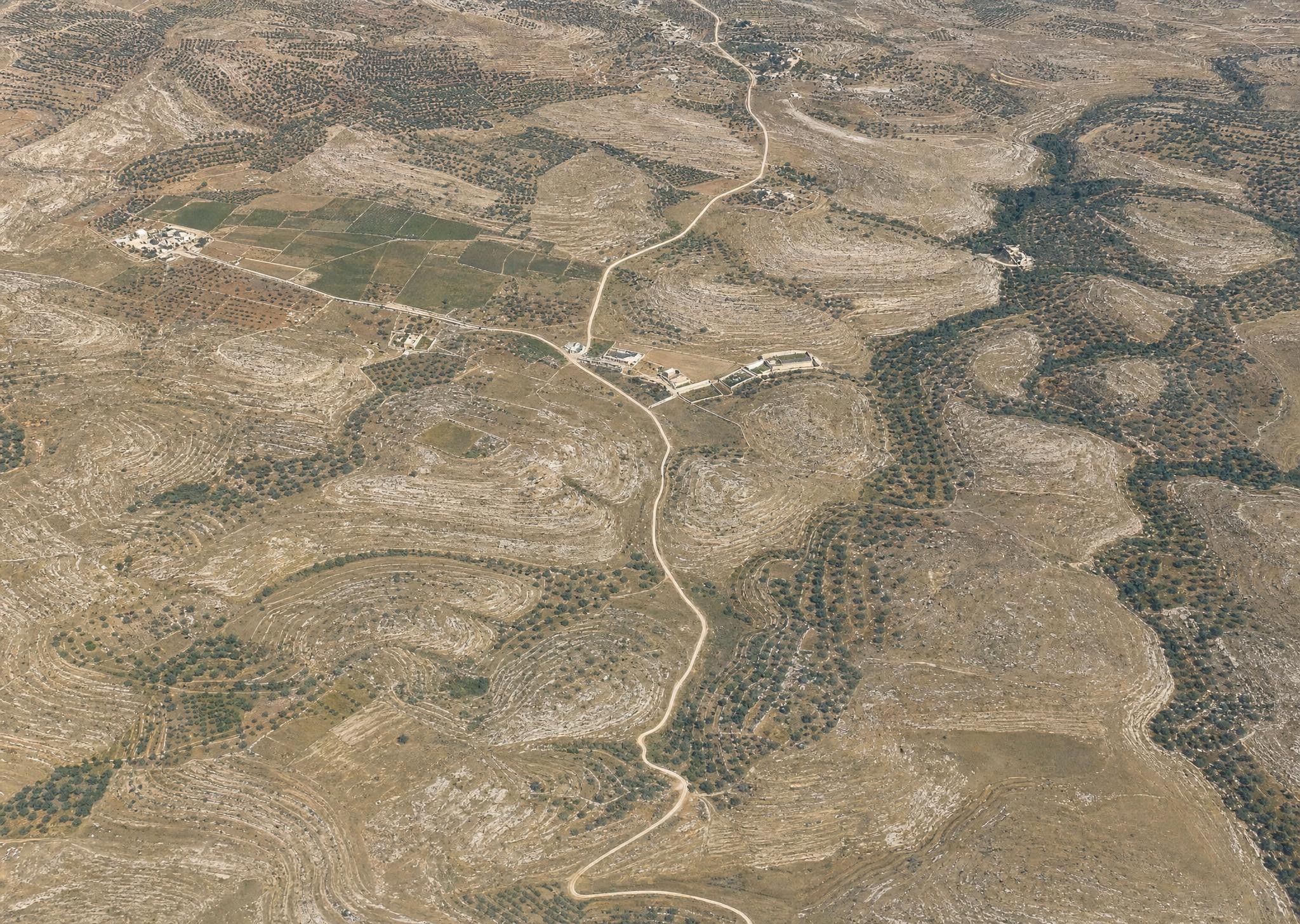
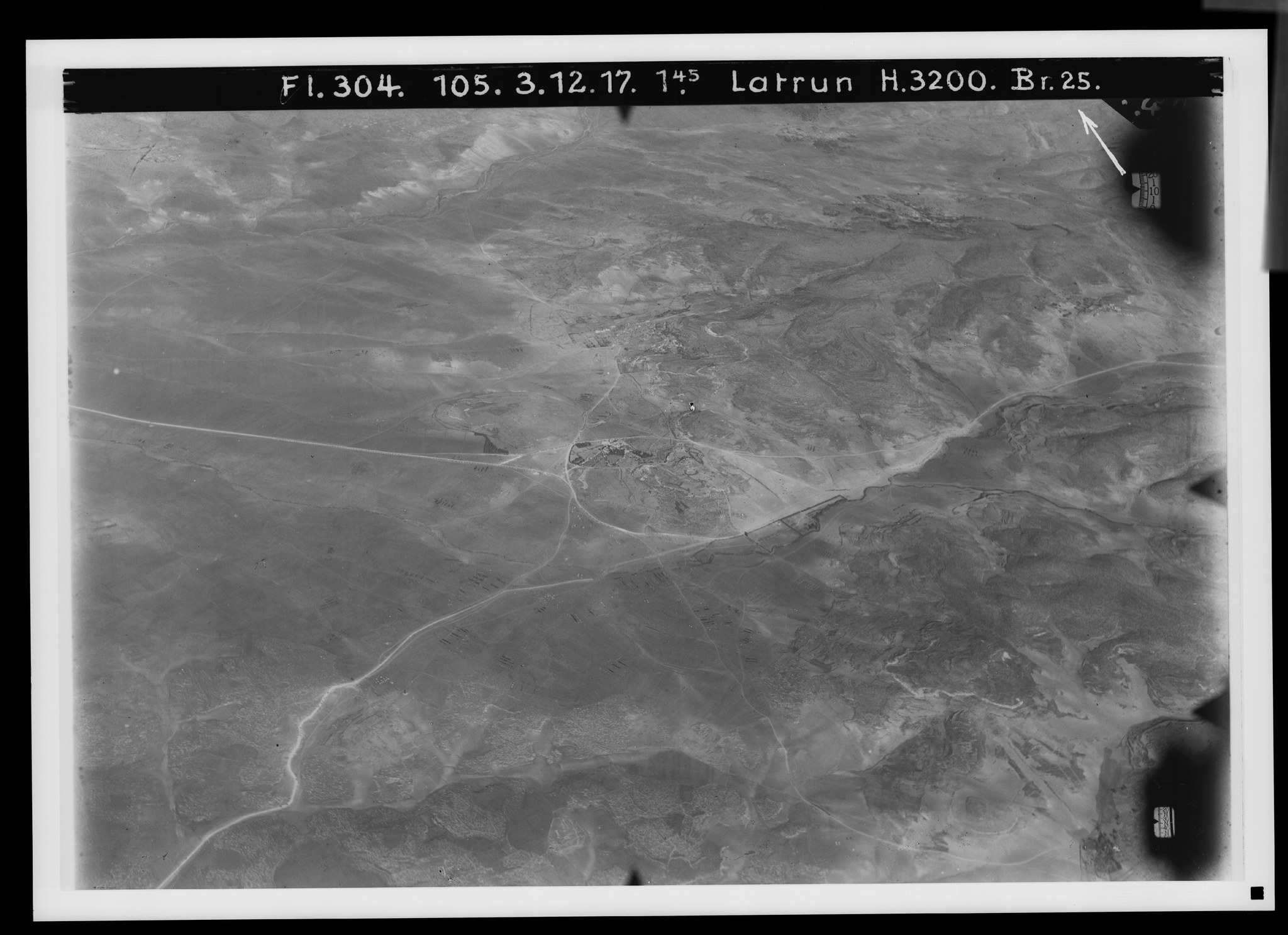
30. The western road from Jerusalem. View toward the southeast. V. 739.
Plate 30. The western road from Jerusalem. View toward the southeast.
FA 304, No. 101. 3 December 1917, 1:45 p.m.; altitude 3,200 m; focal length 25 cm.
A late-autumn picture of Judaean landscape in the early afternoon, from the region of Wadi es-Sarar, to which belongs all the land west of the country's watershed, from el-Bire in the north to el-Chadr in the south. The slope at the lower edge of the picture belongs to Wadi Kalonie, a continuation of Wadi Bet Hanina, 6 km west of Jerusalem (cf. No. 2). A considerable ridge separates this valley from Wadi el-Rrab (), whose branch is Wadi ‘En Raf‘a (), above Wadi Ekbala (), called Wadi ‘En Dschamil ().
The Jerusalem–Jaffa carriage road, which here had sunk to 558 m, has to climb within 1½ km up to 751 m (at ), hence the switchbacks at , whose lowest part is missing. The road then drops again to Wadi Ekbala (), 614 m, and has a new ascent up to 751 m at Der el-Azhar (), where the watershed between the region of Wadi es-Sarar and the Nahr el-‘Odscha begins, whose outermost valleys appear between and —see especially Wadi Katanne ().
Settlements: Kastal (), Suba (), both on towering knolls; Bet Nakuba () above Wadi Ekbala, with the ruin Khirbet Ekbala and the oak grove of Schech ‘Abdallah (); Kerjet Abu Rosch—Kirjath Jearim () on its slope; el-Amur () above Wadi ‘En Raf‘a, before the latter's confluence with the head of Wadi el-Rrab ().
Besides the carriage road, a significant route is the connection—recognizable only at —from the carriage road at Kerjet Abu Rosch over Baten es-Sa‘ide (), 877 m, first to Biddu, then via ed-Dschib to el-Bire. Cf. PJB 1913, pp. 35ff.; 1921, pp. 95ff.
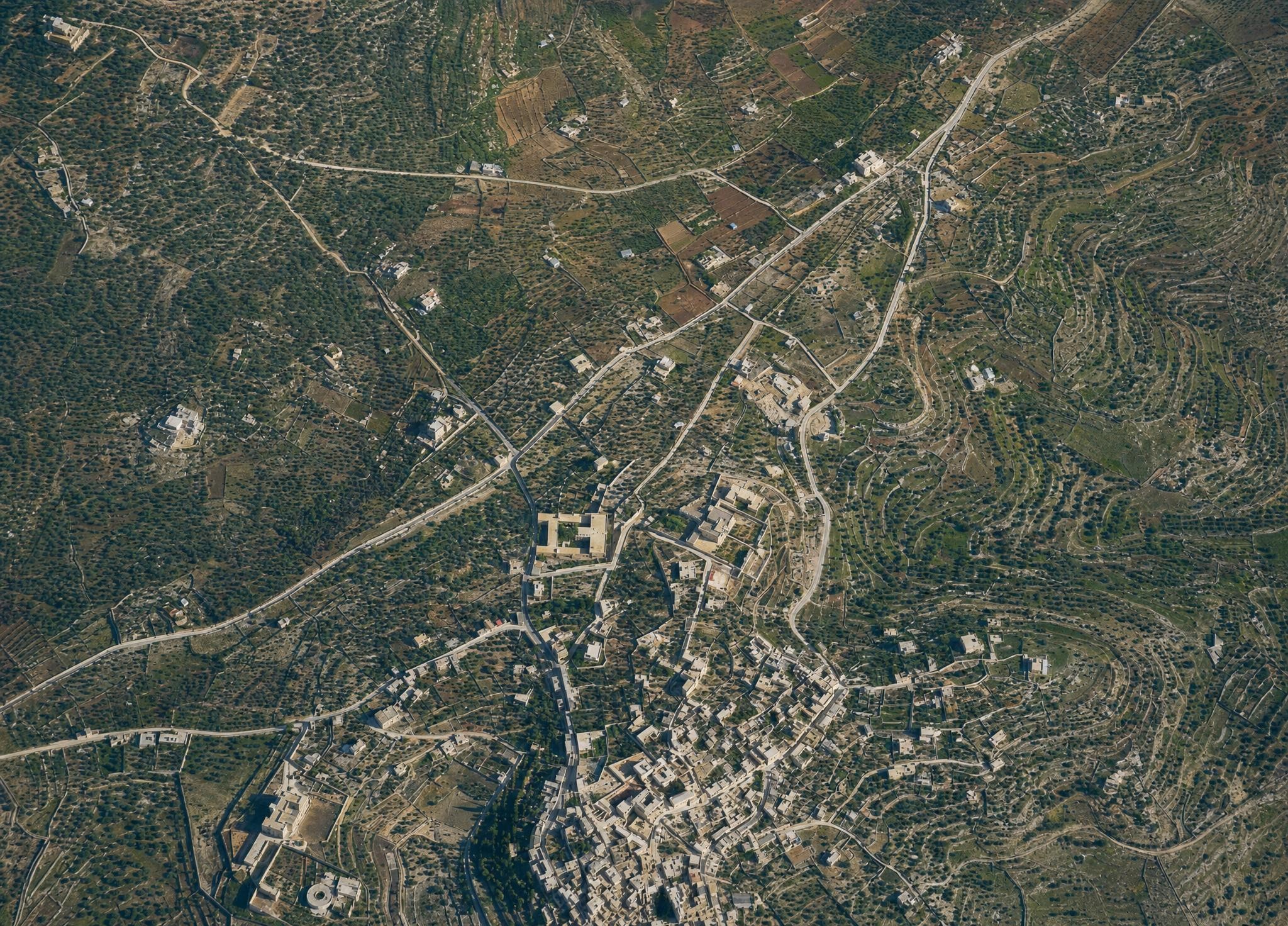
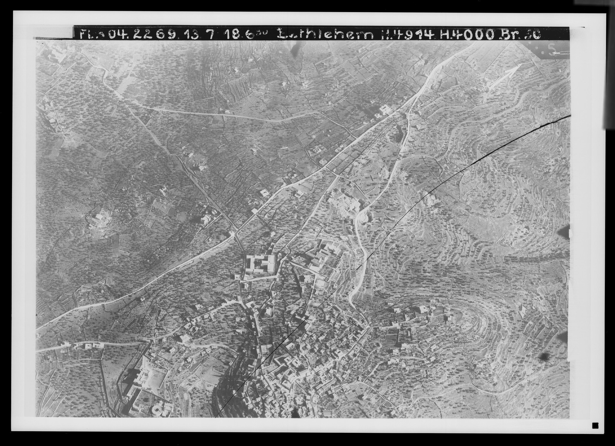
31. Bethlehem, north. View toward the south-southeast. V. 915.
Plate 31. Bethlehem, north. View toward the south-southeast.
FA 304, No. 2269. 13 July 1918, 6:20 a.m.; altitude 4,000 m; focal length 50 cm.
On a ridge connected with the watershed, Bethlehem lies 777 m high between valleys running off toward the east. But toward the west too it appears high, because the upper course of Wadi Ahmed (), which runs along the watershed, separates the height of Bethlehem from the ridge of Bet Dschala, whose beginning is visible at .
The Jerusalem–Hebron road () sends out, near Rachel's Tomb (), a side branch () that makes the connection with Bethlehem. From Hebron a similar side branch does the same (). The road to Bet Dschala runs . The old Bethlehem is to be presumed on this side of the line .
Prominent buildings: the house of the French teaching brothers (), the hospital of the French Sisters of St. Vincent (), the Carmelite convent (), the hospital of the Swedish Jerusalem Society (), and the Christmas Church (Weihnachtskirche) of the German Jerusalem Society (), whose tower is recognizable by its long pointed shadow (morning light).
The cistern before the gate, from which David had water fetched (2 Samuel 23:15), is shown on a northeastern hill spur ().
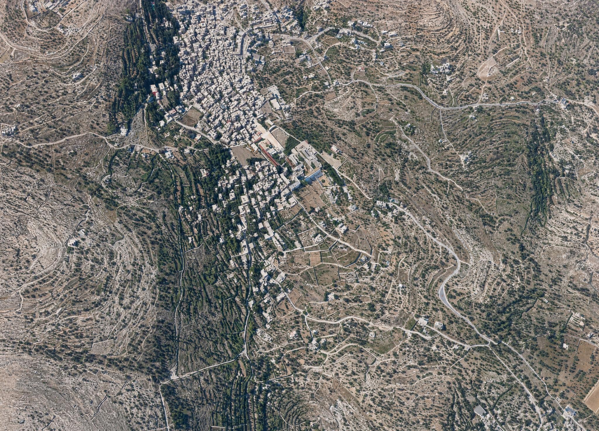
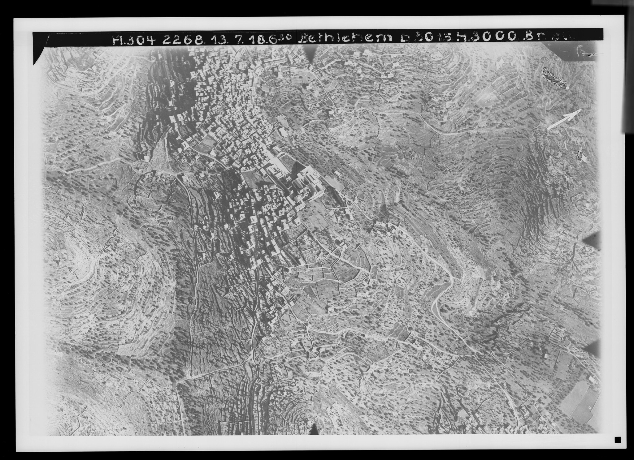
32. Bethlehem, south. View toward the southeast. V. 916.
Plate 32. Bethlehem, south. View toward the southeast.
FA 302, No. 2268. 13 July 1918, 6:30 a.m.; altitude 3,000 m; focal length 50 cm.
About 1½ cm of this picture repeats the previous one, though its direction is not the same. The arrow on both pictures is inaccurate. Old Bethlehem appears here in context (). Adjoining it are the Church of the Nativity () and the southern suburb; all of it between the heads of the valleys—Wadi es-Samur to the east () and Wadi Umm el-Kala to the west ()—which later, joined together, run toward the Dead Sea.
Among the routes, the significant ones are the road to Artas (), to Khirbet Teku‘-Thekoa (), and to the nearby Bet Sahur (). A composite overall view of Bethlehem (aerial photograph), Orte und Wege³, fig. 3.
Terrain set with olive trees all around the town, on the eastern descent of its own height, in the valleys on both sides, and on the mountains opposite.
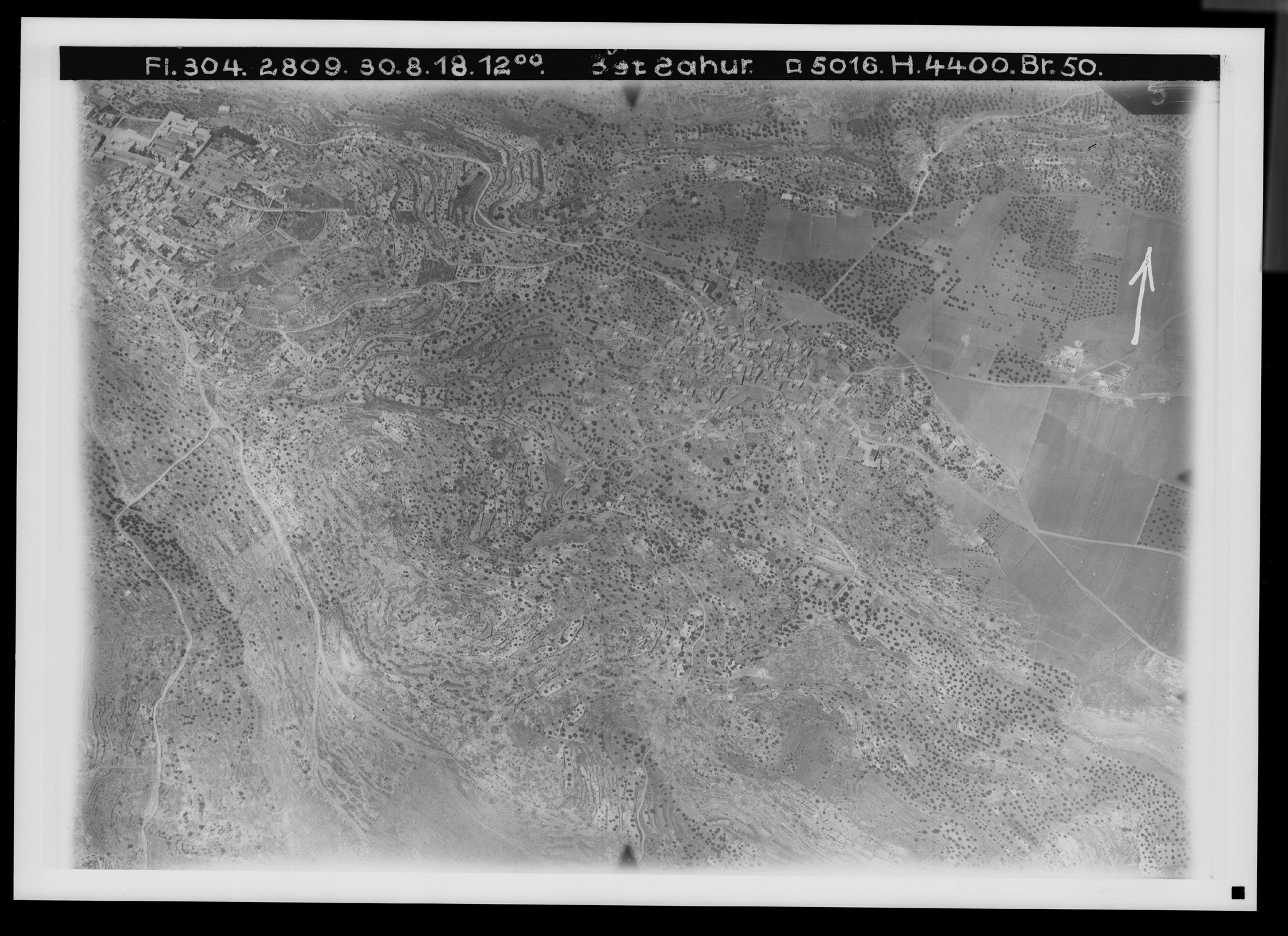
33. Bethlehem and the Shepherds' Field. View toward the south-southeast. V. 918.
Plate 33. Bethlehem and the Shepherds' Field. View toward the south-southeast.
FA 304, No. 2809. 30 August 1918, noon; altitude 4,400 m; focal length 50 cm.
Bethlehem, south, with the Church of the Nativity () is visible at the upper left. One overlooks the southeast-facing descent of the height of Bethlehem, covered with olive groves, which broadens considerably and then runs out into a plain almost entirely occupied by fields (). In this plain lies the olive grove of the Shepherds' Field of the tradition associated with Luke 2:8ff. (); at its edge is the village of Bet Sahur ().
The road to Thekoa can be followed farther here (as far as ). Otherwise noteworthy are the roads to the desert () and the road () toward Sur Bahir, lying to the northeast.
The reason for placing the “Shepherds' Field” in the plain below Bethlehem was a flock tower (Migdal Eder) that existed here, which could be understood as protection for the sheep spending the night near the desert. Cf. Orte und Wege³, pp. 49ff.
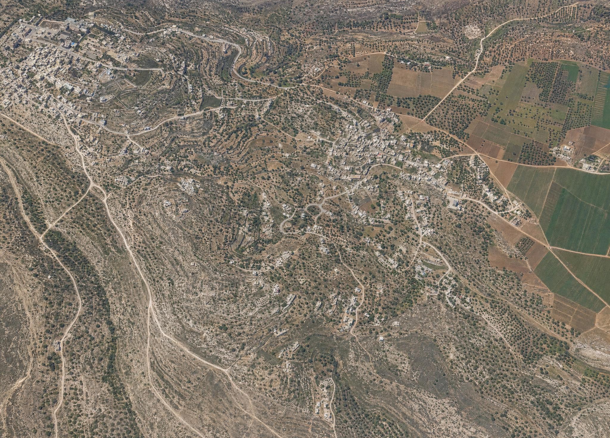
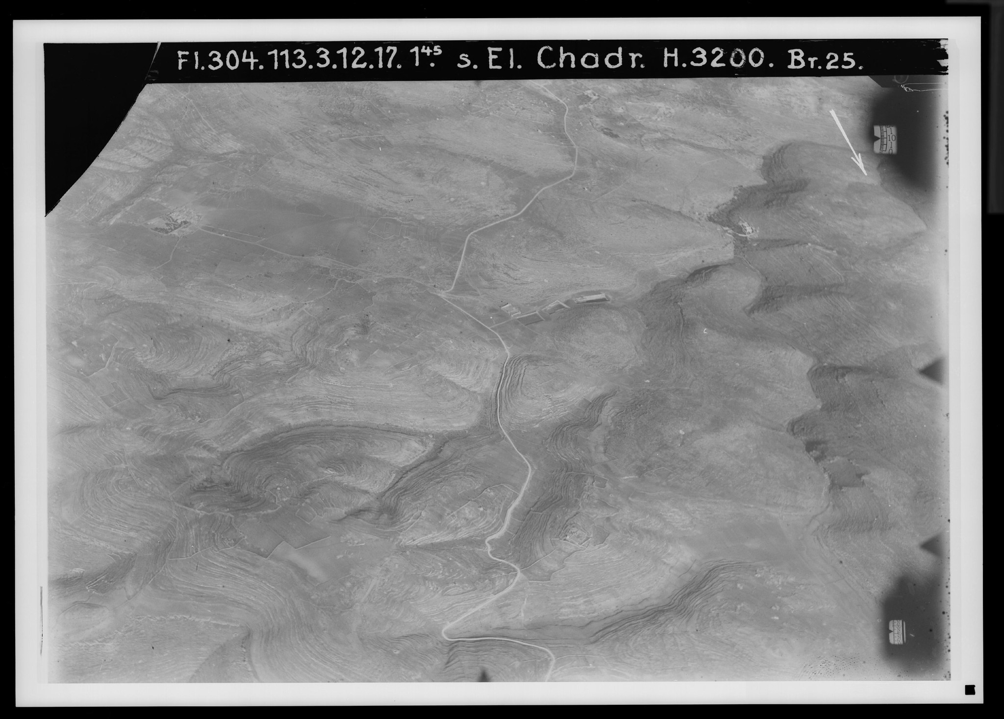
34. The pools and el-Chadr. View toward the northeast. V. 927.
Plate 34. The pools and el-Chadr. View toward the northeast.
FA 304, No. 113. 3 December 1917, 1:45 p.m.; altitude 3,200 m; focal length 25 cm.
Immediately beside the Hebron road, 4 km southwest of Bethlehem, lies the strong spring ‘En Salih (), whose water Pilate probably first conducted to Jerusalem. Three pools (), in part only of Arab origin, were meant to store the spring water that was surplus in winter for the summer; an Arab fortress () guarded the important point. But other springs too lie below in the valley. Beside it lay Etam, now Khirbet Wadi el-Choch (), and the village of Artas () still lies there, with a South American convent opposite it ().
The valley connects here with Wadi el-Bijar coming from the southwest (), which through its western side valleys is linked to the country's watershed; the latter, before the road to el-Chadr () branches off from the Hebron road (), rises in a great westward arc to the height of the massif of Scherifet en-Nebi Danjan (994 m), whose summit the picture no longer shows, so that all the valleys in the picture drain to the Dead Sea except the small basin of el-Chadr, which has no outlet. At the foot of the summit of esch-Scherife, at the bend in the road, is the spring ‘En Masur ().
Barely recognizable is the old line of the Hebron road, which, beyond the pools near , crosses over the heights to the upper course of Wadi el-Bijar (). Small settlements were Khirbet ‘Alja () and Kh. Nustas, or Kh. el-Bire ().
The new water pipeline from Wadi ‘Arrub, which crosses the road on this side of the pools, is not visible, because it did not yet exist in December 1917. Later photographs show it clearly.
35. Hebron and its immediate surroundings. View toward the northeast. V. 963.
Plate 35. Hebron and its immediate surroundings. View toward the northeast.
FA 304, No. 2696. 15 August 1918, 1:30 p.m.; altitude 4,800 m; focal length 50 cm.
Hebron lies in southern Judaea, 927 m high, but—at least as the Arab el-Chalil—it is a settlement of slopes and valley, lying in a valley system that runs by way of Beersheba toward the Mediterranean. It is made up of seven quarters: 1. Harat el-Meschareka (); 2. H. el-Kitun (); 3. H. el-Haram () with the Tombs of the Patriarchs () and the Sultan's Pool () on the valley road; 4. H. el-‘Akkabe and 5. H. el-Kazzazin (); 6. H. Bab ez-Zawie () on the road; 7. H. esch-Schech () on the slope; in addition the extensive northern suburb along the road to Jerusalem ().
The olive-covered hill er-Rumede () is probably the site of the Hebron of the Israelite period.
A plain covered with fields and vineyards lies to the northwest, through which run the road () to Abraham's Oak and, via Bet Dschibrin, into the coastal land; above it, in a great arc, the carriage road to Beersheba (); an older road to the same destination (); the southern road to Jatta along Wadi el-Kadi (); and the eastern road to Beni Ne‘em and ‘En Dschidi on the Dead Sea ().
36. Hebron and the southern Judean hill country. View toward the northeast. V. 961.
Plate 36. Hebron and the southern Judean hill country. View toward the northeast.
Morning photograph.
The city itself appears narrowed and partly concealed by the eastern height, owing to the more oblique photograph. But the view, which in the previous picture reached only as far as the line below e–e, here takes in a large part of the southwestern hill country.
The road to Beersheba can be seen descending into Wadi Sel ed-Dilbe () and, with a long switchback and shortcut, climbing again on the southern slope (), passing the summit el-Hadab (891 m) (). There is no settlement in this area of about 20 km extent. At the edge of the picture, west-southwest , Dura-Adoraim (2 Chronicles 11:9) should lie.
In Hebron are the Haram, the sanctuary of the Tombs of the Patriarchs , the hill er-Rumede , and the vineyards . Its position on the country's great north–south line, the cultivable terrain toward the north, and the mountain spur of er-Rumede are the most important preconditions for David's first capital.
37. The pool and pipeline of Wadi ‘Arrub. View toward the west-northwest. V. 951.
Plate 37. The pool and pipeline of Wadi ‘Arrub. View toward the west-northwest.
FA 304, No. 2278. 13 July 1918, 6:30 a.m.; altitude 3,000 m; focal length 50 cm.
The road from Hebron to Jerusalem () crosses, 11 km before Hebron, the broad Wadi ‘Arrub, which belongs to the eastern slope of the land. An inn () is a much-used stopping place there.
But the valley gained new importance through the Jerusalem water pipeline laid out in 1918 by the British army administration, which restored the catchment pool ()—probably built in the 14th century—for the valley's springs and gave the water a new course through metal pipes. By machine power the water is pumped from there (830 m), through the pipeline visible in the picture as far as , up to the height north of the valley of Wadi ‘Arrub, to a settling basin lying 940 m high, from which it flows off to Jerusalem.
The old conduit ran off to the east () and, by long routes, reached Jerusalem in a covered channel. Cf. PJB 1921, pp. 77ff.; PEFQ 1919, pp. 15ff.
The level valley floor is well cultivated with fields, unlike the slopes to the sides, on which, toward the road, remnants of oak woodland can also be recognized as short black strokes.
38. Descent to the hill country (Bab el-Wad). View toward the north. V. 683.
Plate 38. Descent to the hill country (Bab el-Wad). View toward the north.
FA 304, No. 56. 29 November 1917, 12:30 p.m.; altitude 3,000 m; focal length 25 cm.
Within 5 km the carriage road from Jerusalem to Jaffa descends, between Saris and the inn of Bab el-Wad (), from 704 m to 273 m, without then climbing again, so that with this the elevation of the hill country lying before the mountains to the west has been reached. The ridges that accompany the road in Wadi ‘Ali () represent the descent of the mountains at this point.
Bab el-Wad, “the gate of the valley,” is at the same time the crossing point of the still-important meridional (north–south) road at the foot of the mountains, which can be followed from Beersheba to the Beth-Horon road at the northern boundary of Judaea. The picture shows a part of this road leading south (). It appears to have been improved during the war.
For the route of the Ark of God, carried on a cart from Beth-Shemesh to Kiriath-Jearim (2 Samuel 7:1), this line must be regarded as probable, because only here is an easy crossing possible from Wadi es-Sarar to Wadi ‘Ali and then a comparatively convenient ascent to Kiriath-Jearim. Cf. No. 41.
39. The Jaffa road in the hill country (el-Atrun, Emmaus). View toward the southwest. V. 695.
Plate 39. The Jaffa road in the hill country (el-Atrun, Emmaus). View toward the southwest.
FA 304, No. 105. 3 December 1917, 1:45 p.m.; altitude 3,200 m; focal length 25 cm.
The highest elevation in this region is Ras el-‘Abd, 383 m (); a low point is the lower course of Wadi ‘Ali below el-Atrun (), at 199 m. With this valley there later unites Wadi Selman (), coming from the northeast, which finally drains the plain of Bet Nuba (), once the Valley of Aijalon (Joshua 10:12). At its southern edge still lies Jalo-Aijalon (); in the terrain between the two valleys lies ‘Amwas-Emmaus-Nicopolis (), 225 m, immediately above the more southerly valley el-Atrun ()—once a road fortress, 224 m high—beside it a Trappist monastery (), and farther up Der Ejub (), 326 m.
Along this valley runs the carriage road from Jerusalem (); it formerly crossed the height north of el-Atrun (), but now bypasses it to the south () and, above the valley, takes the direction toward Jaffa ().
The carriage road is crossed by a road coming from the Beth-Horon road in the northeast through ‘Amwas (), which continues southwestward toward Ashdod () and in doing so climbs over into Wadi el-Chalil (), which belongs to the system of Wadi es-Sarar, whereas Wadi ‘Ali and Selman drain toward the ‘Odscha River. A ridge road running parallel to the valley road, beginning behind Kerjet Abu Rosch, leads through Jalo and ‘Amwas back to the line of the carriage road ().
For comparison, view the illustration of the Domus boni latronis in Zuallart (1586), reproduced in Ammann, Reise ins Gelobte Land (new edition of 1919), fig. 60, and not entirely correctly explained on p. 218. The old road to Jerusalem and the castle viewed from the north, before which the Emmaus church is placed, have as their background a multitude of small mountains evidently meant to represent the mountains of Judah, but which have nothing in common with the reality visible at el-Atrun = Latronis domus. See Orte und Wege Jesu³, pp. 241ff.
40. A village in the hill country (Aijalon-Jalo). View toward the west-southwest. V. 677.
Plate 40. A village in the hill country (Aijalon-Jalo). View toward the west-southwest.
FA 304, No. 2980. 15 September 1918, 8:30 a.m.; altitude 5,000 m; focal length 50 cm.
The village of Jalo (), once the Amorite city Aijalon (Judges 1:35), lies on a narrow hill running north–south (288 m) above Wadi ‘Amir (), a side branch of Wadi Selman. Beyond the valley is the ruin mound Tell Koka‘ (), probably the old fortress of the place. West of Jalo is the shallow hollow Challet el-Bijara with the spring Ras el-‘En (), below the hill of Schech Isma‘in (), which one would like to imagine as the ancient place of sacrifice of Aijalon.
The road coming from Jerusalem arrives through Wadi ‘Amir (from ), passes south of Jalo (), and then turns west () and north () toward ‘Amwas, 3 km to the west; cf. No. 39. To the same place leads the line running alongside the settlement across the plain (); to Bet Nuba, across the plain, leads the northeastern road ().
41. By the brook Sorek (Zorah, Beth-Shemesh). View toward the north. V. 755.
Plate 41. By the brook Sorek (Zorah, Beth-Shemesh). View toward the north.
FA 304, No. 1948. 16 June 1918, 6 a.m.; altitude 4,200 m; focal length 50 cm.
A morning view in June; the dark fields suggest summer crops. The Valley of Sorek (Judges 16:4) corresponds to Wadi es-Sarar, the lower course of the important valley that drains the wider surroundings of Jerusalem and through which the railway line from Jaffa has climbed to Jerusalem since 1892. The picture shows the valley not far from where it emerges from the hill country, where Wadi en-Ndschil () and Wadi Bulos () enter the main valley from the south, and Wadi el-Metlak () from the north. Its waterless channel (–) runs through the plain of the well-cultivated valley.
The railway follows the channel at some distance on the south side (from at the top to ). ‘Artuf station (), with a soldiers' camp, lies diagonally opposite the village of ‘Artuf () and the Jewish colony of the same name ().
High above the valley, which lies at about 200 m above sea level, Sar‘a (), Zorah, stands on this side at an elevation of 356 m; it was Samson's home (Judges 13:2). On the far side, at an elevation of only 280 m, are ‘En Schems and Khirbet er-Rmele (), the Beth-Shemesh of 1 Samuel 6:12ff., then the boundary of Philistine territory. Besides the roads leading westward through Wadi es-Sarar, note the north–south route that crosses the valley near ‘Artuf () and intersects the carriage road to Jaffa at Bab el-Wad; see No. 38.
42. The Maccabean city of Modiin, el-Midje. View toward the southwest. V. 654.
Plate 42. The Maccabean city of Modiin, el-Midje. View toward the southwest.
FA 304, No. 151. 14 December 1917, 1:30 p.m.; altitude 2,700 m; focal length 25 cm.
El-Midje, once Modiin, the home and burial place of the Maccabees (1 Maccabees 2:1; 2:69; 13:25), still lies in the hill country. It is separated from the Beth-Horon road to Lydda, which passes to the south but is not visible, by Wadi el-Melaki (), and is isolated on the north by Wadi el-Khanuk (), a branch of Wadi el-Kreka ().
Probably more significant as the ancient settlement site than the present village () is the summit of er-Ras to the southeast (), at 229 m, with a view of the Mediterranean; compare PJB 1912, pp. 19f. To the northeast, likewise at a high elevation (252 m), is the village of Na‘lin () above Wadi en-Natuf (), with substantial olive plantations. The oval area (), probably near Schech er-Rafati, resembles an ancient settlement site.
43. At the edge of the coastal plain (Neballat, Bet Nebala). View toward the north. V. 155.
Plate 43. At the edge of the coastal plain (Neballat, Bet Nebala). View toward the north.
FA 304, No. 137. 13 December 1917, 3:30 p.m.; altitude 2,500 m; focal length 25 cm.
Northwest of el-Midje, immediately beside the coastal plain and near a road that runs northwestward, connecting the Beth-Horon road with the north–south road of the coastal region, lies Bet Nebala (), formerly Neballat (Nehemiah 11:34), at an elevation of only 79 m. Two branches of Wadi Kreka ( and ) cut through its extensive olive plantations. A road from ‘Abud to Lidd () passes it on the way to the plain, where the limestone hills (Senonian) abruptly disappear.
44. A city in the coastal plain (er-Ramle). View toward the southeast. V. 184.
Plate 44. A city in the coastal plain (er-Ramle). View toward the southeast.
FA 304, No. 613. 6 March 1918, 8:15 a.m.; altitude 4,500 m; focal length 25 cm.
In ancient times Lod-Lydda, today Lidd, at an elevation of 58 m, was the center of the coastal region around Jaffa. It has now been surpassed by er-Ramle (), 3 km southwest of it, which can hardly have been Arimathea and first appears in the seventh century AD. The “White Mosque,” with Baibars's tower of 1268, stands to the west, outside the present city (). A large area of orchards lies to the west. The gardens to the north and east belong to Lidd, and the heads of the valleys to the east belong to Wadi Lidd.
The Jerusalem–Jaffa carriage road () skirts the city on the northeast. The railway () crosses the carriage road, reaches its station (), and then bends northeast. The carriage road to Lidd (), which is later crossed by the railway, indicates precisely the direction in which that city lies. A western and a southwestern road () lead to Gaza, and a southern road () to Bet Dschibrin.
The Jaffa–Jerusalem road built by ‘Abd al-Malik around 700, which mostly corresponds to the present carriage road (plates 1, 2, 11, 30, 38, 68), was undoubtedly the cause of er-Ramle's rise. It diminished the importance of the Beth-Horon road, along whose route toward Jaffa Lidd lies, and certainly completely replaced the Roman road that approached the same destination through Kerijet Abu Rosch, Jalo, ‘Amwas, and Lidd. In this way ancient Lidd acquired a powerful rival in young er-Ramle.
C. Samaria and Galilee.
45. The Plain of Jezreel I: view toward the west. V. 1248.
Plate 45. The Plain of Jezreel I: view toward the west.
FA 304, probably December 1917 (see Plain of Jezreel IV); morning.
The Plain of Jezreel marks the separation of northern Palestine from central and southern Palestine. This division was created by a transverse fault running from southeast to northwest and made Galilee a distinct region.
At the same time, the plain forms a natural connection between the coast and the Jordan Valley and serves as one of the country's granaries. It has also been a theater of military campaigns from the time of Deborah and Barak (Judges 4–5) to Napoleon and the recent World War.
The view is taken from the eastern edge of the plain near el-Fule, perhaps the Cyamon of Judith 7:3, at the end of the Assyrian encampment around Bethulia. It is now the Jewish colony of Merchabia.
In the foreground is a farmstead belonging to el-Fule (). In the middle distance () stands the village of el-‘Afule. Behind it, the Nahr el-Mukatta, the Kishon, begins its course toward the Mediterranean in a channel that is usually dry here.
The hills in the background form the northern edge of the Samaritan highlands, here called Bilad er-Roha. Their most prominent heights are Umm el-Harite (), at 312 m, and Umm el-Fahm (), at 393 m.
Between these heights, the pass of ‘Ara opens toward the coastal region. At its outlet, probably at , lies Tell el-Mutesellim, Megiddo; compare PJB 1914, pp. 34ff., 76ff.
A dark line behind the farmstead in the foreground () marks the newest route across the plain, the Haifa–Damascus railway. It is crossed by a second line, the old Nazareth–Jerusalem road (), while the new carriage road does not turn south until immediately before el-‘Afule.
46. The Plain of Jezreel II: view toward the northwest. V. 1252.
Plate 46. The Plain of Jezreel II: view toward the northwest.
Morning photograph.
A two-centimeter strip from the right edge of view I is repeated here at the left.
In the foreground is the road from el-Fule to el-‘Afule railway station, with its group of houses (). Behind it rises the Carmel range. El-Muhraka (), at 514 m, is one of the range's highest summits as seen from this direction and is the presumed site of Elijah's sacrifice; compare PJB 1914, pp. 37f., and 1922/23, pp. 24f., 26f.
At the foot of Carmel, whose northwestern end remains out of sight, the Kishon finds its way to the sea. Low, oak-covered hills (), containing the German colonies of Waldheim and Bethlehem, close off the plain.
From the photographer's position near el-Fule, at an elevation of 78 m, however, a narrow strip of the sea may be visible at . The rising hill country on the right already belongs to Galilee.
In the center of the picture () runs the old road from Nazareth to Jerusalem.
47. The Plain of Jezreel III: view toward the north-northwest. V. 1253.
Plate 47. The Plain of Jezreel III: view toward the north-northwest.
Morning photograph.
A three-centimeter strip of plate 46 is repeated here.
The first tier of the Galilean hill country rises opposite. Its highest point is en-Nebi Sa‘in near Nazareth (), at 488 m, which appears lower than Jebel el-Kafze, the “Mount of Precipitation,” at 392 m on the edge of the plain ().
Besides elevated Nazareth, en-Nasira (), Jafa () is clearly recognizable. Less certain are lower-lying Jinjir, at 136 m near ; above it, el-Mujedil, at 238 m; and farther on, probably Ikhnefis () and Jebata ().
All the pictures show the fertile plain, the site of intensive grain cultivation, lying bare, which accords with a photograph taken in December. Flying Detachment 304 celebrated Christmas here in 1917.
The outlet of the valley of Nazareth (), the descent of the carriage road from Nazareth to the plain (), and its old continuation across the plain toward Jenin and onward to Jerusalem () can be followed.
48. The Plain of Jezreel IV and Jebel ed-Dahi from the west. V. 1253a.
Plate 48. The Plain of Jezreel IV and Jebel ed-Dahi from the west.
FA 304, No. 146. 13 December 1917, 3:30 p.m.; focal length 25 cm.
The panorama lacks a view toward the northeast that would show Tabor as the southern end of the Galilean hill country.
Looking east, one sees the final 5 km of the plain before its descent to the Jordan. Because the viewpoint lies between the villages of el-‘Afule and el-Fule, el-Fule itself is visible on its height (); below it is the farmstead seen in the foreground of panorama I, and above it () is the summit of Jebel ed-Dahi, at 515 m. This is the (Little) Hermon of Origen and others, but not the Hermon of Psalm 89:13 (Orte und Wege, 3rd ed., pp. 205f.), and perhaps the hill of the oracle-giver in Judges 7:1.
At its southern foot lies Solem (center of ), recognizable only as a bright line among its orchards, the Shunem of Elisha (2 Kings 4:8ff.).
The plain rises eastward to 123 m at Jezreel, now Zer‘in, though the right edge of the picture does not extend that far. The mountain wall in the background, only faintly distinguished from the edge of the plain (), belongs to the region of ‘Ajlun beyond the Jordan. The isolated summit on this side () is Kokab el-Hawa, probably named after Agrippina, the wife of Claudius (PJB 1922/23, pp. 43f.).
The prophet Elisha at Shunem and the kings Ahab and Jehu at Jezreel are among the historical figures of this landscape, as is Saul, who crossed the heights in the background to the medium of Endor behind Jebel ed-Dahi (1 Samuel 28:7ff.).
Important traffic routes are the Nazareth–Jerusalem carriage road (i–i), the el-‘Afule–Nablus railway (h–h), the Haifa–Damascus railway (), and the road () that passes el-Fule and descends toward Beisan.
49. Gideon's Spring of Harod (‘Ain Jalud), from the northeast. V. 1279.
Plate 49. Gideon's Spring of Harod, ‘Ain Jalud, from the northeast.
Afternoon photograph.
At the southern edge of the eastern descent of Palestine's transverse fault, about 3 km below Zer‘in—Jezreel, in the valley of Nahr Jalud, which flows toward the Jordan, the strong spring of this stream rises in a grotto beneath a rock face. Its water is now used by Jewish colonists to irrigate the entire valley below.
Here Gideon, whom Arab legend replaced with Goliath, once tested his fighters (Judges 7:1ff.; compare Weidenkaff, PJB 1921, pp. 18ff.); German soldiers are refreshing themselves in it in the picture.
The spring, 37 m below sea level, is a good example of the deep position of water veins in limestone country. The stream formed by the spring is not a collector of groundwater, but a drainage channel carrying the spring water down into the depths of the Jordan Rift.
50. Nazareth—en-Nasira. View toward the east. V. 523.
Plate 50. Nazareth—en-Nasira. View toward the east.
FA 304, No. 428. 20 January 1918, 4:30 p.m.; altitude 2,500 m; focal length 25 cm.
This late-afternoon picture has dark shadows on the eastern slopes, which nevertheless clarify the relief of the terrain. An irregularly articulated mountain chain, whose highest point is en-Nebi Sa‘in (), at 488 m, forms the background of the city, which climbs from about 344–350 m toward the height out of a valley () that ultimately descends to the Plain of Jezreel.
The oldest part, with its market lanes, lies in the shadowed ravine (); at its outlet is the Church of the Annunciation (). At the beginning of the valley are Mary's Spring (, upper left) and St. Gabriel's Church (, lower right). On the height are the Salesian orphanage and church ().
The carriage road in the valley () provides the connection toward Haifa and Jerusalem. It formerly continued straight across the height (), with Tiberias as its ultimate destination, but now climbs the height by a broad southern detour (beginning at ) and also provides a connection with Tabor by means of a branch line.
A road toward Seffurie and ‘Akka runs northward over the height (); northwestward, a road runs through Ma‘lul toward Haifa (), with a branch toward ‘Ailut (). The road descends to the carriage road.
Compare Orte und Wege3, pp. 61ff. There, fig. 7 also shows another aerial photograph of Nazareth, an oblique view from the east-southeast, not northeast as stated there because of the incorrectly oriented arrow. See also Schumacher, ZDPV 1891, pp. 235ff. (with plan); Range, Nazareth (1923).
51. Tabor and eastern Galilee. View toward the southwest. V. 525.
Plate 51. Tabor and eastern Galilee. View toward the southwest.
Afternoon photograph.
As the southern outpost of the Galilean hill country, connected with it only by a low saddle, Tabor, now et-Tur, rises to 562 m on a northeastern extension of the Plain of Jezreel that belongs hydrographically to the Jordan basin. Its domed form is unique in Palestine.
The drainage passes Tabor () and then runs southeast toward Wadi el-Bire. Behind Tabor the terrain descends toward the same drainage basin, but Sahl el-Ahma () can be recognized as a second eastern channel running south. Its highest point, Karn Hattin, at 316 m, should be visible above Tabor but cannot be recognized.
The chain of heights rising behind Tabor's summit and continuing to the left edge of the picture () belongs to the region of Lubiye; above it in the distance are the Upper Galilean mountains near Safed.
Wooded Tabor bears a Franciscan monastery on its summit (). Its church, dating from the Crusader period and now rebuilt, is regarded as the site of the Transfiguration of Jesus (Matthew 17:1ff.), though that event belongs in the Golan; see Orte und Wege, 3rd ed., pp. 203f., 215f.
Barak went from here into battle (Judges 4:12, 14; PJB 1913, pp. 44f.). At the western foot is the village of Deburiye (), the Dabaritta of Josephus. A road from Damascus and Tiberias to the coast at Caesarea passes through the gap here.
The road visible from to , however, leads to en-Nain, above which the photograph was taken.
52. Southern end of the Sea of Tiberias. View toward the southwest. V. 974.
Plate 52. Southern end of the Sea of Tiberias. View toward the southwest.
Afternoon photograph.
Behind the southern slope of the plain Sahl el-Ahma, which rises westward (), appears the southern third of the lake, sunk into Palestine's rift valley at 208 m below sea level. It is open only toward the Jordan Rift, yet dammed by a low rise in the ground through which the Jordan drains on the western side.
Originally there were two converging outlets, between which lay el-Kerak-Beth Jareach (); to the east is the Jewish farm Degania ().
The river then winds onward, with el-‘Abediye and its palm grove beside it (). Before that, Wadi Fejjas enters from the west (). It has broken through the mountain ridge at the edge of the rift () and can be followed some distance upstream through Sahl el-Ahma ().
On the western shore of the lake is the Jewish colony Kinnereth (), and on the southern shore is Samakh railway station (). Beyond is the Golan plateau, dropping steeply to the lake and broken by the valley of Fik. Before it stands the table mountain of ancient Hippos (); above it is the village of Fik-Aphek (), with Wadi es-Samak () running parallel.
To the south the plateau ends at the deep incision of the Yarmuk (), the Jordan's largest tributary. Its course can be followed upstream to the inflow of the Rakkad () and beyond, as far as . The tributary Wadi el-Mas‘ud coming from the Golan (), and especially the Yarmuk's course through the Jordan plain (), are visible.
Gadara-Umm Qeis lies on the height south of the Yarmuk, beyond the right edge of the picture.
53. Eastern shore of the Sea of Tiberias from the south-southwest. V. 1297.
Plate 53. Eastern shore of the Sea of Tiberias from the south-southwest.
Midday photograph.
From Samakh on the southern shore of the lake, the view surveys the eastern shore and the slope, rising about 500 m above the lake, to the Golan plateau. Set into this slope is the table mountain of ancient Hippos (). On the shore, though not recognizable, is Kursi (), sometimes identified as Gergesa. Above it is Hermon, completely covered with snow, at 2,759 m (), revealing that the photograph was taken in winter. Beside it are the extinct volcanoes of the northern Golan: Tell Abu en-Neda (), at 1,257 m, and, farther right, Tell Abu Yusuf, at 1,029 m. Near the shore at the left edge, but invisible, is ancient Bethsaida-Julias.
Jesus' miraculous feedings belong on this eastern shore of the lake; compare Orte und Wege, 3rd ed., pp. 184ff.
Projections emerging from the depths behind the camel in the center of the picture show that the southern shore is not entirely flat, although it is not rocky. Here too the lake appears as a tightly enclosed basin of Palestine's rift valley, open only southward, distinguished from the Dead Sea by its fresh water, the cultivability of its shorelands, narrow though they are, and its closer relationship to the surrounding fertile plateau.
54. Kinnereth and et-Tabera. View toward the southeast. V. 973.
Plate 54. Kinnereth and et-Tabera. View toward the southeast.
Morning photograph.
At the northwestern corner of the Sea of Tiberias, a spur of the limestone mountains reaches the lake in the hill Tell el-‘Oreme (). This forces the shore road coming from Tiberias to go around it on the north () and only then descend again toward the northern shore ().
More important, however, was the road's northeastern continuation toward the medieval Jordan bridge and Damascus, for it formed part of the “Way of the Sea” of Isaiah 8:23 and of the Via Maris that connected Damascus and Cairo in the Arab Middle Ages. Khan el-Minye (), almost entirely removed since this photograph was taken, belonged to this road; Capernaum or Bethsaida has wrongly been sought near it.
Using an ancient canal, a modern artificial road has recently been constructed across the promontory ().
Beside it stands the hospice of the German Association of the Holy Land (), with gardens and banana plantations on the shore and an avenue of eucalyptus trees leading to the farm buildings (). On the hilltop is the settlement site el-‘Oreme (), ancient Kinnereth (Joshua 19:35).
In the background, the carriage road from Tiberias to Safed climbs with a switchback from the plain of el-Ruwer on the western shore of the lake (); a connecting road () links it to the steamer landing ().
At the southern foot of the hill is the spring basin of ‘En et-Tine (). To the east () is the well-cultivated plain of the springs of ‘En et-Tabera-Heptapegon, which are no longer visible in the picture. The short valley Khallet es-Sammak () enters this plain from the northwest.
Capernaum lies only 3 km farther east. An aerial photograph of it exists in private ownership, but unfortunately has not yet been made accessible to the public. Compare PJB 1922/23, pp. 56ff., and Orte und Wege, 3rd ed., pp. 139ff.
55. Tiberias and the ascent to the plateau. View toward the northeast. V. 971.
Plate 55. Tiberias and the ascent to the plateau. View toward the northeast.
Midday photograph.
The present and medieval city of et-Tabariye, still entirely walled, has fortifications extending into the lake () and openings in the wall on the south, west, northwest, and north (), corresponding to its principal approaches.
Along the lake, the road leads south () toward the Jordan Valley and Beisan, and north () toward Safed. The steep western road () toward the Plain of Jezreel and ‘Akka, and the carriage road bending northward () toward Nazareth, must overcome the escarpment of the rift valley.
At the northwestern corner of the present city is the citadel (); at the western gate is the German inn (); in the north are the buildings of the Scottish Mission (); beside the lake is the Franciscan monastery (); and outside the gate is the school of the Italian Franciscan sisters ().
Southward along the lake extends the site of ancient Tiberias as far as the mountain spur of Qasr el-Bint (), which bore the fortress of Herod Antipas.
Beyond the edge of the mountain slope appears the opposite rim of Sahl el-Ahma (), and from still farther away Jebel ed-Dahi () and Tabor ().
56. Tiberias from above. View toward the north. V. 972.
Plate 56. Tiberias from above. View toward the north.
FA 304, No. 427. 20 January 1918, 3:30 p.m.; altitude 2,000 m; focal length 25 cm.
The surroundings of Tiberias lie in the mountain's shadow; from the city only its flat roofs shine out.
The roads outside the city, the Scottish Mission (), the Italian school (), and cemeteries () stand out. In addition to the routes named under No. 55, there is the old road to Lubiye (), now a bridle path, which cuts across the carriage road's northward bend.
Both pictures show that the ancient city, like the present one, blocks the shore road and thus possesses military importance despite its low position, but also how narrow the shoreland is, offering no sustenance for a larger city here.
The ancient city farther south had the advantage that, together with its fortress, it formed an even more complete barrier. At that time, with the shoreland and the northern Jordan Valley more heavily populated, traffic along the shore was undoubtedly much livelier than today.
57. Safed in Upper Galilee. View toward the south-southeast. V. 519.
Plate 57. Safed in Upper Galilee. View toward the south-southeast.
Morning photograph.
At a considerable elevation of 838 m and visible from afar, only 12 km north of the Sea of Tiberias, the city of Safed-Zephath, surrounded by orchards, lies clustered around its now unfortified castle hill (). This hill is to be regarded as the highest outpost of the rise between Wadi et-Tawahin in the west, or its upper course Wadi ed-Jinn (), and Wadi ‘En el-Hamra () in the east.
The Jewish quarter is in the west (), and the Muslim quarters are in the foreground (). The most important approach from the south passes through Wadi ‘En el-Hamra (), while the carriage road from Tiberias, making a broad eastern detour, is visible only where it enters from the east ().
Visible are the village of Biria () and, lower down, ‘En ez-Zetun; farther on, Kaddita () above the uppermost head of Wadi ed-Jinn; and Tetaba () beside Wadi el-Amuka (), which descends toward Lake Huleh. Safed grew large as the center of a district under Arab rule and through later Jewish immigration.
In earlier history it appears only as a place fortified by Josephus during the revolt against the Romans (Jewish War II.20.6); because of its high position, it may have served for the new-moon fire signals (j. R. h. S. 58a).
Upper Galilee, crossed only in the north by the road from Damascus to Tyre, was a hinterland of Palestine. The location of Safed, which could be made accessible to wheeled traffic from the lowlands only by a long detour, is further evidence of this.
D. The Mediterranean coast.
58. Sidon with harbor and gardens. View toward the west-southwest. V. 2.
Plate 58. Sidon with harbor and gardens. View toward the west-southwest.
Afternoon photograph.
Remnants of an older shoreline lie off Palestine's otherwise straight coast, resulting in the formation of natural harbors that also established the importance of ancient Sidon, now Saida.
The picture does not show the broad southern harbor in front of the southern part of the city, but it does show the reef that helped form it, artificially cut through at one point (). From this reef, a row of rocks once developed as a mole protects the northern harbor on the north (). A fortress connected to the mainland by a bridge, Kal‘at el-Bahr (), guards the entrance to the now-silted harbor.
The present city corresponds to the medieval city. At its southeastern corner is the fortress Kal‘at el-Mu‘ezze (); westward is the site of Fakhr ed-Din's palace (); in the north is the great Khan Fransawi (); and within the city is the principal mosque ().
The importance of the present city, however, no longer rests on its harbor, but on its orchards on the narrow coastal plain, irrigated from groundwater wells and used for orange exports. By the marginal hills is the suburb el-Baramiye ().
The road to Beirut follows the shore northward and continues southward along the city's eastern edge. Today it gives no indication that it was Palestine's principal military road in ancient history (PJB 1916, pp. 21ff.); but the commerce of the Phoenician coastal cities was likewise inconceivable without it.
59. Tyre and its isthmus. View toward the east. V. 4.
Plate 59. Tyre and its isthmus. View toward the east.
Morning photograph.
Originally, a remnant of the older coast lay offshore of the present coastline here in the form of two islands. These islands, with their northern bay and a southern harbor protected by reefs, were the site of the ancient “New City” of Tyre, now occupied by Sur.
The formerly larger northern island, now joined to the smaller southern one, extends southward about as far again as the present city. In 332 BC Alexander the Great connected the island with the mainland by a siege causeway, which through the accumulation of sand grew into an isthmus 600 to 2,000 m wide.
The foreground of the picture shows the isthmus with the road to Sidon and Beirut (). The present city still has the old northern harbor (), but it is too shallow for larger steamships. At the southern end is the ruin of a Crusader church ().
60. Akko and its harbor. View toward the northwest. V. 6.
Plate 60. Akko and its harbor. View toward the northwest.
Morning photograph.
At the northern end of the Bay of ‘Akka, on a southward-pointing tongue of land, lies ‘Akka, formerly Ptolemais and originally Akko. The northeastern corner of the bay, protected by the tongue of land, formed a natural harbor.
An artificial harbor was created by moles whose remains are still visible (), and there was apparently a smaller harbor by the lighthouse (). Walls enclose the two seaward sides, and double ramparts the northern side of the city, in the form given them by the Turks in 1843.
The castle, now a prison (), and Jezzar Pasha's mosque of 1780 () stand at the northern edge of the city; two large caravanserais () are conspicuous. There are exits toward the east () and north (, ), the latter probably dating from very recent times.
The surf on the beach along the western side reveals a west wind; it is calmer on the bay, with its fringe of dunes () and the road to Haifa.
61. Akko and its surroundings from above. View toward the south. V. 5.
Plate 61. Akko and its surroundings from above. View toward the south.
FA 304, No. 423. 20 January 1918, 2:30 p.m.; altitude 1,600 m; focal length 25 cm.
The flat sandy shore of the bay; the high seacoast beach extending northward, likewise covered with dunes, with the large pool of water within the dunes (), which reveals that the picture was taken in the rainy season; the well-cultivated plain with the large orange groves of el-Bahje (); and the palm grove near the shore () are the characteristic features of the surroundings of ‘Akka.
Jezzar Pasha's aqueduct reaches the city () through the pool of el-Bahje (). From Haifa, the road and railway line come along the shore (); the former continues northeastward (), turns north from el-Bahje (), and passes es-Semiriye () and its gardens.
The northeastern route passes el-Bahje toward el-Kabri and the northern Galilean hill country (). A more easterly road leads to Kefr Yasif (), leaving the village of el-Manshiye () to one side; and the actual eastern road, branching from the shore, leads toward southern Galilee (Safed, Saffuriye) ().
In this way the land connections important to the harbor city's significance can be surveyed.
62. Akko and its surroundings from the east. V. 1346.
Plate 62. Akko and its surroundings from the east.
Morning photograph.
The picture includes only the southern part of No. 61. The farmsteads here at are the northern farmsteads by the shore in that picture (9f), while the palm gardens here at correspond to the gardens there at 14g–17h.
The eastern road runs here from to , the road to Kefr Yasif from to , and the actual northeastern or northern road from to . The hill in the foreground () is Tell el-Fukhkhar (29 m) on the English map. The Belus River, now Nahr Na‘men, is not visible because it lies farther south.
Sidon, Tyre, and Akko, however important they are for the coast of Palestine, represent not Israelite but Phoenician culture; and the description of the market of Tyre in Ezekiel 27 proves that the culture of the contemporary world had entrepôts here, compared with which Palestine's Israelite hill country, with its olives and vines, was an impoverished hinterland.
Yet this contrast meant conflict, for which Carmel, projecting from the hill country into Phoenician territory, was a historical arena (1 Kings 18). Without this conflict, the history of Israel would have disappeared without world significance into the history of the ancient Near East; and when its fruit had ripened for sowing in the world, it was these harbors that served for its export (Acts 21:3, 7; 27:3).
Yet it should also be remembered that, alongside the contrast, fertilization by world culture was indispensable. That Solomon's Temple did not arise without Tyre may stand as an outward sign of this.
63. Haifa and its bay from Carmel in the west. V. 1347.
Plate 63. Haifa and its bay from Carmel in the west.
Photograph probably taken in the afternoon.
At front right is Carmel near the Carmelite monastery, with the road leading there from Haifa (). On the sea bay that cuts southward into the land, unique on the Palestinian coast, lies the city of Haifa-Hefa () with its landing pier (); in the foreground is the German Colony.
There is no true harbor, but the promontory of Carmel protects the roadstead from west winds. Beyond the bay are a sandy beach () and palm woodland ().
Above them are the alluvial soil and marginal hills of the coastal plain; rising beyond these are Hermon (), the Jebel Heder range (), and Jebel Tur‘an (). The Kishon gleams brightly ().
The roads on this side of the city () are the beginning of the coastal road leading around the promontory. The railway running along the beach cannot be made out.
64. Eastern Haifa with railway station. View toward the north-northeast. V. 10.
Plate 64. Eastern Haifa with railway station. View toward the north-northeast.
FA 304, No. 426. 20 January 1918, 3:10 p.m.; altitude 1,900 m; focal length 25 cm.
Waves and surf on the sandy beach reveal a north wind (the arrow is wrong), while the shadows indicate the northeast direction.
Of the city of Haifa, only the eastern end with its suburb is visible; beside it is the railway station (), with the beginnings of the Haifa–Damascus () and Haifa–el-Kantara (Suez Canal) () railway lines.
The carriage road (), with a connection from the station (), has Nazareth as its next destination. The connection to the beach () serves traffic toward ‘Akka, but also toward the boats' landing place ().
The palm gardens on the left belong to the Kishon's alluvium; its outlet is no longer visible. Above the city is Carmel's rocky slope.
The sea bay and railway today make Haifa, still insignificant in the Middle Ages, Palestine's principal harbor. Sidon, Tyre, and Akko have declined into harbors serving merely coastal traffic.
65. Caesarea and the dunes. Lower edge toward the northeast. V. 13.
Plate 65. Caesarea and the dunes. View toward the northeast.
Midday photograph.
A break in the Mediterranean coast's dune belt, formed by a depression extending inland and again enclosed by dunes, is the site of Caesarea, built by Herod I in 13 BC as a Roman city intended above all as a maritime city and meant to outstrip Tyre in rank. An artificial harbor was created by constructing a dam that left an opening on the north side. Reefs extending into the sea favored the harbor works. A theater and an amphitheater, which would probably be better described as a hippodrome (Orte und Wege, vol. 3, p. 293), together with a temple of the emperor on elevated ground, were the city's monumental buildings (Josephus, Antiquities XV.9.6).
Present-day Kesariye, settled by Bosnians (), is the walled medieval city, with the ruins of a church () and a harbor whose southern mole bears a castle (). In front of the northern mole is a second dam formed from columns (, recognizable as a narrow line). The harbor of the Herodian city may have lain farther south, from . A theater can be recognized at the southern end of the city (), into whose enclosure drifting sand has penetrated, and a hippodrome near the western wall ().
These remains can be reconciled with Josephus's account if the passage cited above is construed as follows: “He built a theater on the south side of the harbor, so situated that one could conveniently overlook the sea, and farther back an amphitheater capable of holding many people.” Remains of the enclosure wall may be visible at in the drifting sand and at the northern end of the ancient city (, diagonally).
A road leading east () connects the harbor with the north–south road of the coastal region; the road to Haifa runs along the shore (). The ancient aqueduct follows the line of the road from .
Caesarea was Palestine's most important harbor in Roman times. It has now fallen into ruin together with its artificially constructed harbor. Given the limited importance of the coastal road in this region (see no. 66), it is all the less likely to revive, since it lacks the favorable location of Haifa and Jaffa.
66. Mediterranean coast south of Caesarea. Lower edge toward the west. V. 17.
Plate 66. Mediterranean coast south of Caesarea. View toward the west.
Flight 304, no. 282. 10 January 1918, 2:30 p.m. Altitude 3,700 m; focal length 21 cm.
The picture was labeled Nahr el-Falik, but it lacks that stream's characteristic rocky ridge, divided by a canal within the dune belt. Instead, it corresponds to the stream of Wadi el-Hawarit, which flows into the sea 10 km south of Caesarea and drains all of central Samaria. For its otherwise unknown name there, Nahr Iskanderune, see ZDPV 1914, pp. 340f.
It is a good example of the drainage channels characteristic of Palestine's coastal region, carrying away groundwater impounded behind the dune belt. A permanent watercourse begins here near Tell Mudd ed-Der () within a marshland extending far to the north and south (), adjoined by cultivated land on the south toward the sea () and on the north toward the interior ().
Dunes block the straight beach and are cut through obliquely by the river (); their steep slope faces the surf-fringed coast (). A road coming from Kesariye, mostly following the beach, climbs the dunes () and passes east of the double pond Birket en-Nejjar (), with the village of Mukhalid as its next destination. Another road branches southeastward () in the direction of Burj el-‘Atut and Kalansawe in the coastal plain.
It is noteworthy that the passable dune road along the beach had no significant historical importance throughout the region from Caesarea to Gaza. Only from Saladin's time is a Crusader military expedition known to have passed this way (PJB 1916, p. 27). This may be connected with the fact that no important towns could develop in or beside the unhealthy marshland created by the dunes.
Trading caravans and military expeditions therefore preferred the route running 13 km inland at the foot of the hill country. Here it was Palestine's coastal road; see PJB 1916, pp. 22ff. The arrow points too far west.
67. Jaffa with suburbs. Aerial oblique. Northeast. Reichsarchiv.
Plate 67. Jaffa with suburbs. View toward the northeast.
Flight 300, no. 1375. 19 March 1917, 9:30 a.m. Altitude 200 m.
A row of rocks forms a small natural harbor open to the north (), which, together with the hill lying beside it, gave rise to the city of Joppa, now Jaffa, whose oldest part corresponds to this hill (). Modern seagoing ships must of course anchor in the roadstead; boats passing through the rocks handle traffic from the land to them.
The Franciscan monastery and church () stand on the seaward side, and a mosque in the north (). The southern suburb () is less important than the northern suburb (), with the station () and the German Colony () with its church ().
The carriage road to Jerusalem () is linked with the station by the new Jemal Pasha road (). The northeast road toward Haifa, or Nablus, begins at ; the eastern road, with two branches (), goes to Selme; the southern road to Gaza begins at . Orange groves with a few palms surround the city on the landward side.
68. Jaffa and its wider surroundings. Aerial oblique. West. V. 84.
Plate 68. Jaffa and its wider surroundings. View toward the west.
Flight 304, no. 283. 10 January 1918, 2:30 p.m. Altitude 3,700 m; focal length 21 cm.
The beach with its surf, the rocks off old Jaffa (), the roadstead with ships () outside the harbor, and the suburbs of new Jaffa, extending far to the south and north, among them Jewish Tel Aviv (), are the first features that catch the eye. Even the dune land has been occupied by settlements on both sides.
The area lying behind belongs to Wadi Misrara, which bends northward near Jaffa in order to flow into the ‘Oja River; see its course (). We were already in its basin at er-Ramle (44), Bet Nebala (43), Jalo (40), el-Atrun (39), and Bab el-Wad (38). Beside it lies the German colony Sarona (); on the edge of hill country adjoining to the north, up to 84 m high, are Selme () and Nebrak-Ibn Ebrak (), once Bene Berak (Josh. 19:44).
Near the dunes in the south are the Jewish agricultural school Mikveh Israel () and the village of Yazur (). Within Jaffa's garden land are the Russian church () by the Tabitha cemetery and the German Colony ().
From its station (), the railway line to Jerusalem makes a northward curve () before taking the direction toward Jerusalem (), while the carriage road runs directly (). The road to Gaza runs along inside the dunes (), and the road to Haifa passes Sarona ().
The gap in Palestine's dune belt, whose cause I do not know, made the development of the city of Jaffa possible. Its connections inland, for which the Beth-Horon road (no. 22) once had importance, since the Arab period the line of the carriage road through Wadi ‘Ali (nos. 38, 39, 40), and now the railway in Wadi es-Sarar (no. 41), belong to this as well, as does the nearness of the provincial capital Jerusalem.
The picture covers about 6 km along the coast and, inland from the beach, 8 km. The arrow points north-northwest.
E. Jordan Valley and Dead Sea.
69. Herodian Jericho and the Jerusalem road. Aerial oblique. Southwest. V. 1041.
Plate 69. Herodian Jericho and the Jerusalem road. View toward the southwest.
Flight 304, no. 2049. 22 June 1918, 5:45 a.m. Altitude 4,500 m; focal length 50 cm.
The picture coincides with the lower part of no. 20 and repeats the course of Wadi el-Kelt from 12d–7k on that picture, but because of the strong shadows of the early light it renders the individual features much more three-dimensionally, above all the deep gorge of Wadi el-Kelt () as far as its emergence from the desert hill country into the Jordan plain, which likewise would be desert without artificial irrigation.
The aqueduct of Wadi el-Kelt therefore finally leaves the gorge (). Remains of old irrigation works are the ruined pools (, and ).
The carriage road to Jericho with its bends (), the route of Wadi Medbah ‘Aiyad to the Hajla ford (), the path on the north side of Wadi el-Kelt (), and the meridional road on the western edge of the plain () show the nearness of important traffic passages.
Antique remains are represented by Khirbet Kakun (), Tell Abu el-‘Alaik (), Tell es-Stuh (), and Bet Jabr et-Tahtani (), which contain ruins of Herodian buildings in Jericho but also prove that Herodian Jericho was more a large district than a closed city.
70. Present-day Jericho with irrigated land. Aerial oblique. North. V. 1029.
Plate 70. Present-day Jericho with irrigated land. View toward the north.
Flight 304, no. 724. 27 March 1918, 3:30 p.m. Altitude 3,000 m; focal length 25 cm.
On picture 69, Wadi el-Kelt reaches as far as the first bend here (), and on no. 20 as far as the second bend (). The mostly waterless valley, which can be followed beyond present-day Jericho-er-Riha (), a place that was never walled, as far as , receives from the north two side branches, of which the more easterly is connected with Sidd Tesun ().
The terrain east of it (), now Ard el-Merajim, may be proposed for the Plain of Achor (Josh. 7:26; PJB 1913, p. 18). The most important feature in the picture is the sharply delimited irrigation area of Jericho, darker because of its cultivation with grain or fruit trees: Fersh er-Riha.
The canal from Wadi el-Kelt (see no. 69) irrigates the western part south of this valley (). Elisha's Spring, ‘En es-Sultan (see no. 71), sends part of its water by an aqueduct () to the eastern area beyond the valley () and, on this side, irrigates everything lying east of the line of the canal to the aqueduct (). From the farther northward ‘En Duk (cf. no. 78), water once came to the western terrain on this side of the valley ().
The carriage road from Jerusalem (), after the Nebi Musa road (no. 19) has joined it (), crosses the valley () and continues beyond Jericho: 1. to the Dead Sea (), 2. to the Hajla ford, the baptismal site of the Jordan (), 3. to the Jordan bridge (), 4. northward to the meridional road of the western Jordan Valley (), and 5. to Elisha's Spring and ancient Jericho (), with connection to the meridional road.
To Herodian Jericho belongs the narrow rectangle closed by two curves (), which can only be understood as the hippodrome of Herod.
71. Ancient Jericho and Elisha's Spring. Aerial oblique. South-southeast. V. 1031a.
Plate 71. Ancient Jericho and Elisha's Spring. View toward the south-southeast.
Flight 304, no. 1701. 4 June 1918, 6:45 a.m. Altitude 5,000 m; focal length 50 cm.
A morning picture with bright light on Tell es-Sultan (), 214 m below sea level, the fortified ancient Jericho of the Israelite and pre-Israelite periods uncovered by the excavations of Sellin and Watzinger; the furrowing of the hill is a result of the excavation. Beside it is Elisha's Spring, ‘En es-Sultan, with a new elongated spring basin (, right).
The road to New Jericho () bounds the irrigated area; the bend at is the same as the bend at 12m on no. 70, and its continuation toward the meridional road is . West of it are Tell es-Samarat (), the northern head of the hippodrome (cf. no. 70), and the outlet of the Sidd Tesun gorge (), which plunges vertically beside the monastery of Jebel Kuruntul () and then connects with a gorge () draining to Wadi el-Kelt.
The area west of ancient Jericho is bounded on the north by the narrow ridge Dahret et-Teniye (). Along it a canal coming from ‘En Duk runs northward (); below it are former sugar mills (). A second branch (), now probably out of use, continues the direction of the main canal ().
This main canal may have been the conduit built by Archelaus, by which he deprived the city Neara of half its water in connection with the expansion of the royal residence at Jericho. This fits the fact that this conduit benefited the ground below the mountain descent, too high for Jericho's spring, where the Herodian buildings in Jericho lay. The founding of Archelais reported by Josephus, Ant. XVII 13, 1, in connection with this therefore has nothing to do with the aqueduct (erroneously PJB 1913, p. 74; 1914, p. 16). Roads going northward signify Jericho's connection first with Wadi en-Nue‘me, whose owner was once Neara.
72. The Mount of Temptation and its eastern surroundings. Aerial oblique. Southeast. V. 1033.
Plate 72. The Mount of Temptation and its eastern surroundings. View toward the southeast.
Flight 304, no. 2052. 22 June 1918, 5:45 a.m. Altitude 4,500 m; focal length 50 cm.
What was in the upper left corner of no. 71 appears here, shifted more nearly upright, at the top in the middle. The drop (there 3a) of Sidd Tesun appears here with the monastery at ; Jebel Kuruntul, the traditional mountain of the temptation of Jesus and probably once the fortress Dok (see Orte und Wege3, p. 106), visible there only with its lower half (4a), also stands out with its walled summit, about 310 m above the plain ().
The foot of the mountain is encircled by the conduit from ‘En Duk (), which then continues toward Dahret et-Teniye () and accompanies its southern slope (). The sugar mills are at ; ancient Jericho at .
A distinct irrigation area is the slope below Jebel Kuruntul toward Wadi en-Nue‘me (), which runs to the Jordan independently of Wadi el-Kelt (see nos. 78, 79). Pictures 70–72 show ancient and modern Jericho in its relation to the mountains and the springs of its surroundings. Full judgment of its position is provided only by the overview in picture 79.
73. The Dead Sea and the Judean Desert. Aerial oblique. Northwest. V. 1060.
Plate 73. The Dead Sea and the Judean Desert. View toward the northwest.
Flight 304. Afternoon photograph.
The lake that fills a basin of Palestine's meridional rift down to 390 m below sea level,* now called Bahr Lut, "Lot's Sea," is enclosed on the east and west by 600–1,000 m high escarpments of the hill country on both sides. The escarpment on this side disappears from the picture because it was taken from the west; the one on the far side is concealed by haze.
Visible below the hill country are only the low shore projections connected with the recession of the lake in an older geological epoch, which are usually called the Lisan terrace after the peninsula el-Lisan, "the Tongue" (), visible in the southeast.
Opposite the peninsula appears the foreland of the region of Sebbe-Masada (), farther north the region of ‘En Jidi-Engedi (), then the widely projecting point, sharpened only by the cross view, of Wadi Hasasa and Wadi ed-Deraj (), and finally the narrower foreland of Wadi el-Ruweir with small marginal pools.
In the background the marl-covered rock-salt deposit of Jebel Sudum is faintly recognizable, and behind it the southern end of the lake (), which was probably the site of Sodom. The projections in the east () belong to the mouth of the Mujib-Arnon, while in the foreground on this side Wadi en-Nar, coming from Jerusalem, seems to descend and finally disappears in a gorge ().
The main valley comes from the west (); the southern side valley () is probably Wadi Jerfan, 6 km from the shore of the Dead Sea. Invisible to the north remain 14 km of the western shore and 35 km of the eastern shore, about one third of the whole lake of 75 km length.
* See H. Schroetter, Das Tote Meer (1924), pp. 12f.
74. Central western shore of the Dead Sea. Aerial oblique. South. V. 1062.
Plate 74. Central western shore of the Dead Sea. View toward the south.
Afternoon photograph.
The western descent to the Dead Sea, dissected by water runoff, is surveyed here from the south, with corresponding shortening of the south-north dimensions. The picture begins in front with the region immediately north of ‘En Jidi; there follows the alluvium coming from Wadi Sder (), the promontory Ras Mersid () below probably the highest summit of this region (), Ras esh-Shakf, 317 m, that is, 707 m above the lake, and finally the foreland of Wadi Hasasa and Wadi ed-Deraj (), behind which the original image still showed the foreland of Wadi el-Ruweir ().
The approximately 17 km of the west coast surveyed here show how hostile the Dead Sea was to cultivation because of its steep coasts, and how it had to act as a separating boundary between the eastern land and the western land. A culture of its own could not develop on its shores. Therefore it was "dead," not because of the salt brine of its water.
75. Southern western shore of the Dead Sea. Aerial oblique. North-northeast. V. 1061.
Plate 75. Southern western shore of the Dead Sea. View toward the north-northeast.
Morning photograph.
This picture, labeled "Sea of Galilee," was easily recognized as belonging to the Dead Sea and could be precisely located by means of a photograph of the western shore taken by Dr. Schwöbel from Machaerus.
The unmistakable form of the mountain of Sebbe-Masada () was the key. One therefore looks southward from the region of ‘En Jidi and surveys the southern Judean Desert as far as the boundary of Palestine.
In the south the picture extends along the lake for 27 km as far as the beginning of Jebel Sudum (). From there follow the outlet of Wadi ez-Zuwera (), Wadi Umm Barrek (), Wadi Umm el-Bedun (), Wadi el-Kidre (), and, on this side of Sebbe, Wadi Seiyal (), Wadi Sufesif (), and Wadi el-Khashebe (), 10 km south of ‘En Jidi.
The barren foreland of the hill country is as distinctive as the hill country itself, which is essentially level though completely torn apart by runoff. The background of the picture should be sought on the left in the direction of Kurnub, and on the right in the region of Tell el-Milh.
All visible land is uninhabitable. That Wadi ez-Zuwera and Wadi Umm Barrek have their springs does not alter the character of the rain-poor limestone country.
76. Southern cape of the Dead Sea peninsula. Aerial oblique. Northeast.
Plate 76. Southern cape of the Dead Sea peninsula. View toward the northeast.
FA 305, No. 533. 12 May 1918, 6:30 a.m.; altitude 400 m; focal length 21 cm.
The southern point of the Dead Sea peninsula is customarily called Cape Molyneux. It projects into the lake with a fairly straight, 14 km-long broad side facing northwest; its northern tongue, 5 km long in all, forms a narrow bay with the eastern shore of the lake, while its southern tongue points across toward the western shore.
On that western shore the region of Jebel Sudum () is visible as a dark shadow in the south. The eastern shore was also recognizable along the entire upper edge of the source image. The picture therefore gives a view of the shallow part of the lake, where Irby and Mangles in 1818 still saw the peninsula enclosed by a dry beach more than 1 1/2 km wide.
Here one must imagine the Plain of Siddim of Genesis 14:3, in which the cities Sodom, Gomorrah, Admah, Zeboiim, and Zoar lay.
The streams coming from the east, Seil ‘Esal, en-Numera, el-Kerahi, el-Fefe, and Khnezire, must once have united there into a river flowing toward the northern basin of the Dead Sea. The territories of the five cities will have corresponded to the irrigated areas of the five streams (PJB 1908, pp. 84f.).
The American expedition of 1924 also reached no different result (Albright, Bulletin 14, p. 8).
The peninsula, rising only 43 to 53 m above the lake surface, is covered by a level gypsum layer that toward the foreground preserves the remnant of an older, higher position; see Blanckenhorn, Naturwissenschaftliche Studien am Toten Meer und im Jordantal, pp. 165f. The apparent tower () at the left edge is a depression.
77. Mouth of the Jordan into the Dead Sea. Aerial oblique. Northwest. V. 1063.
Plate 77. Mouth of the Jordan into the Dead Sea. View toward the northwest.
FA 304, No. 208. 3 January 1918, 2:15 p.m.; altitude 3,000 m; focal length 21 cm.
The terrain around the mouth of the Jordan presents a khanging picture, especially influenced by the water level of the Dead Sea. The annual low and high levels caused by winter rain, differing by 30–90 cm; see Masterman, PEFQ 1913, pp. 192ff.; and the lake's steady rise observed over the past century, 3 m from 1892 to 1917, produce major changes on the flat northern shore, to which the river's alluvium also contributes.
A photograph from early January may be regarded as fairly normal because winter rain can hardly have exerted much influence by then. An aerial photograph of 4 September 1918, a drawing of 21 April 1913, and my visit on 19 November 1921 show major differences; see PJB 1924, pp. 73ff.
Clearly visible here is the sharply bounded course of the river (), whose muddy water also colors the lake where it enters. Alluvial tongues accompany the mouth on both sides (PJB 1924, fig. 3), together with lagoons connected with the lake; see the connection points at .
Along the lake shore a third lagoon extends (), joining the one on this side of the mouth (). That the river, from which a narrow channel drains through the eastern alluvial tongue (), is independent of the lagoons used for salt extraction seems beyond doubt, although I cannot explain the firmness of its bank walls, which are covered with reeds and trees of Suaeda monoica and tamarisks.
The higher, pale-colored terrain on this side and the terrain beyond, appearing so dark only in this picture because of its marshy character and also weaker illumination, belong to the Lisan floor of the Jordan plain. I do not venture to decide whether Wadi el-‘Ademe, coming from Nebo, has its mouth near .
78. The baptism site on the Jordan: Hajla ford. Aerial oblique. South. V. 1069.
Plate 78. The baptism site on the Jordan: Hajla ford. View toward the south.
FA 304, No. 689. 22 March 1918, 2:15 p.m.; altitude 3,000 m; focal length 25 cm.
No more than 3 km upstream from the mouth, the Jordan runs in long curves. A photograph of 27 March 1918 shows only slightly farther than No. 77 and apparently already there lets the river pass into the form that is then the most common one: short, irregular loops going back and forth within the depression cut about 60 m into the Jordan Valley.
Occasional sections of a second watercourse beside it () are parts of an older riverbed, probably blocked by the collapse of a high marl wall at the edge of the depression, forcing the river to tear out a new bed. Because trees and bushes make it appear dark, the Jordan depression is called ez-Zor, “the thicket”; the transitional zone from the plains on both sides to the depression, torn apart by runoff from the wider Jordan Valley, is called el-Ketar, “the humps.”
Here Wadi el-Kelt enters from the west () with a northern tributary (), and the short Wadi el-Kharrar from the east () with a small stream. The Monastery of St. John, Kasr el-Yehud (), midway down the plain at 334 m below sea level, sends a road in the direction of the latter (), where an ancient tradition seems to locate the Bethabara, or Bethany, of John's baptism.
A second road leads to the mouth of Wadi el-Kelt (), where Jesus' baptism by John now has its traditional location on the Jordan (). This is connected with the ford of Hajla, now unusable, which crossed the river east of it, near . The present main road from Jericho here descends into the Jordan depression south of Wadi el-Kelt (); a direct road leads to the monastery (). An aqueduct from the Kelt stream marks the dark line ().
Compare Orte und Wege3, pp. 88ff., and fig. 9, an aerial photograph of the baptism site from closer range.
79. Jordan Valley near Jericho. Aerial oblique. View toward the west-southwest. V. 1071.
Plate 79. Jordan Valley near Jericho. Aerial oblique. View toward the west-southwest.
Morning photograph.
About 15 km of the Jordan's course are surveyed, from above the entry of Wadi el-Mellaha () in the north to Wadi el-Luman () and the ford el-Henu in the south. One observes the river depression, dark from its green vegetation, though the actual course does not appear.
From the east, the entries of Wadi Nimrin (), Wadi el-Kharrar (), and Wadi Kefrein () reach almost to the mouth. From the west, besides Wadi el-Mellaha with Wadi el-‘Oja (), come Wadi Mesjadet ‘Isa () with numerous upper branches, Wadi en-Nue‘me (), Wadi el-Kelt (), and Wadi el-Luman ().
No settlement is visible except New Jericho (), with the dark irrigated areas of ‘Ain es-Sultan () and of ‘Ain ed-Duk and Wadi en-Nue‘me (). Ancient Jericho () cannot be recognized.
The roads to the Jordan bridge (), to the Monastery of St. John (), to the baptism site () past ‘Ain Hajla (), and to the Dead Sea () leave Qasr Hajla () to the east. From Nebi Musa come the obliquely running roads to the Jordan bridge ().
The Gilgal tamarisks of en-Netele are to be sought at , and ‘Ain el-Rarabe at , on the northern bank of Wadi el-Kelt.
The cloud-covered plateau in the east shows Nebi Osha‘, 1,096 m, as the highest point in the north (), with ‘Ajlun behind it. Wadi Shu‘eib () coming from es-Salt, then Wadi Kefrein () with a sharp corner where it enters the Jordan plain (), and Wadi Hesban coming from the right and then bending () to join Wadi Kefrein, divide the Moabite eastern land, now el-Belka.
The cloud-shadowed depression () belongs to Wadi Na‘ur, a tributary of Wadi Kefrein. The road to Amman and es-Salt () and the road to Madaba () climbing Tell el-Metaba‘, Mount Peor, are the most important roads here.
80. Jordan Valley north of Jericho: Wadi Abu ‘Obeda. Aerial oblique. East-northeast. V. 991.
Plate 80. Jordan Valley north of Jericho: Wadi Abu ‘Obeda. Aerial oblique. View toward the east-northeast.
FA 304, No. 2287. 14 July 1918, 5:30 a.m.; altitude 1,500 m; focal length 25 cm.
The picture must be viewed from its upper edge if the valley furrows in the plain are to appear as depressions, but it has not been placed accordingly here so that the relation of near and far remains normal. In the hilly landscape lying before the mountain escarpment between ancient Jericho and Wadi el-‘Oja, the streamless Wadi Abu ‘Obeda () arises a little south of Wadi el-‘Oja, visible at lower right (), into which it flows.
Beyond the level area are Wadi Mesjadet ‘Isa () and Wadi en-Nue‘me (), which can be followed upward to the region of ‘Ain ed-Duk (). There, above the irrigated land, one also sees the conduit running along the foot of Jebel Kuruntul () and bending forward at illuminated Dahret et-Teniye (). The picture still reaches ancient Jericho () with its irrigated land and Wadi el-Kelt ().
The straightest road north follows the foot of the hill country (); the main road in this direction lies farther east (), with roads branching from it () toward the Jordan ford el-Mendesse.
Here one understands the ancient hostility between Neara and Jericho reported by the rabbis (Vaj. R. 23); it concerned the water Archelaus took from the people of Neara; see no. 71.
But the book of Joshua also reports peculiar things about this region. Ephraim's southern boundary included Neara, touched Jericho, and ran to the Jordan (Josh. 16:7); from Dahret et-Teniye it must therefore have separated the cities' irrigated areas. Jericho was Benjaminite (Josh. 18:21), likewise with territory extending to the Jordan, but Judah possessed the northern shore of the Dead Sea as far as Benjaminite Beth Hoglah (Josh. 15:6) near ‘Ain Hajla.
For Beth-Haarabah, which according to Josh. 15:6 and 18:18 lay south of the Judahite boundary, yet is called Benjaminite in 18:22, Alt, PJB 1925, proposed the ruin mound of ‘Ain el-Rarabe mentioned above, without clarifying the boundary's course.
81. The Jordan at the Jericho bridge: Roraniye ford. Aerial oblique. View toward the east. V. 1073.
Plate 81. The Jordan at the Jericho bridge: Roraniye ford. Aerial oblique. View toward the east.
FA 304, No. 951. 21 April 1918, 8:00 a.m.; altitude 4,000 m; focal length 25 cm.
Deviating eastward and then bending back westward, the river runs northward in its depression, which is covered with tamarisks and Euphrates poplars. The apparently bridged ford () and the site of the wooden bridge of that time () determine the course of the roads crossing the river here.
The road comes from Jericho (), crossing Wadi en-Nue‘me (). On the eastern side, the road to es-Salt runs eastward (), parallel to Wadi Nimrin (), while the road to Madaba runs southeastward ().
On both sides of the Jordan depression lies the furrowed drainage zone of the Ghor lowland.
82. The Jordan and Wadi el-Mellaha. Aerial oblique. View toward the east-northeast. V. 1082.
Plate 82. The Jordan and Wadi el-Mellaha. Aerial oblique. View toward the east-northeast.
FA 304, No. 1652. 2 June 1918, 6:00 a.m.; altitude 600 m; focal length 21 cm.
About 11 km north of the Jericho bridge, this picture begins with the course of the Jordan and follows it for 3⅓ km. Within the depression, the winding river, with an older side channel, soon strikes the western and then the eastern steep bank.
The ford Umm esh-Shert () accounts for a road crossing the Jordan here (). A north–south road runs between the Jordan and the parallel Wadi el-Mellaha () and sends a connection toward Khirbet el-‘Oja et-Tahta ().
The side valley entering the Jordan from the east (), unnamed on any map, lies between Wadi el-Abjad and Wadi Ishkerara.
83. The Jordan south of Adamah. Aerial oblique. View toward the southeast. V. 1086.
Plate 83. The Jordan south of Adamah. Aerial oblique. View toward the southeast.
FA 304, No. 237. 1 January 1918, 10:00 a.m.; altitude 3,700 m; focal length 21 cm.
This picture begins about 7½ km farther north than the right edge of No. 82 and encompasses 5 km of the Jordan's course as far as the ford of ed-Damiye-Adamah (), through which the road from Nablus to es-Salt crosses ().
An important road to Jericho also runs southeast from here (). It crosses Wadi ed-Jozele (), the lower course of Wadi el-Far‘a, which comes from the land of Samaria but, because of its gradient, turns southward in the Jordan Valley and here runs parallel to the Jordan for 9 km before flowing into it. The picture ends about 2 km north of the mouth.
The road running southward between the two valleys () belongs to a route running directly along the Jordan, but one inconvenient for major traffic.
84. The Jordan and the Jabbok (Nahr ez-Zerka). Aerial oblique. View toward the west.
Plate 84. The Jordan and the Jabbok (Nahr ez-Zerka). Aerial oblique. View toward the west.
This picture was published in a periodical as “Jordan Valley with Judean Desert.” It actually shows the Jordan at the boundary of Samaria and the hill country lying opposite to the east. The course of the Jordan shown begins almost 9 km north of ed-Damiye and extends for 7 km.
The noteworthy points in the south are the fords of Umm Sidr and Abu Sidr (), with a road connecting the Samaritan el-Buke‘a with the Jabbok Valley, and Tell Abu Sidr (), which once guarded these fords. In the north, the valley by ‘Arak Abu el-Hashish, east of Khirbet Mofia, appears to be the last one on this side ().
A distinctive feature of the Jordan Valley in this region is that the western hill country is separated from the drainage zone toward the Jordan only by a narrow terrace along which the north–south road runs (). Only in the east is there also a plain about 4 km wide before the hill country of el-Me‘rad and el-Belka rises.
The boundary between these two regions is formed by Nahr ez-Zerka, formerly the Jabbok. Its valley, with the settlement site Tulul ed-Dahab-Mahanaim, breaks through the hill country here () and then continues as a shallow channel across the plain (). Near the Jabbok's emergence from the hill country lie Tell Deir ‘Alla-Succoth () and Tell esh-Sha‘be (), perhaps Penuel; compare PJB 1913, p. 72f.
Here the road running through the hill country north of the Jabbok and continuing toward the Umm Sidr ford (see above) crosses the north–south road of the eastern Jordan Valley, which runs along the foot of the hill country ().
A shortcut passes the rock tunnel el-Makhruk () toward the Jabbok's outlet (). Beside the north–south road are the Muslim pilgrimage site Abu ‘Obeda () and then ‘Ammata () by Wadi Rajib (), which comes from the hill country and separates the region of el-Me‘rad from Jebel ‘Ajlun.
Near the mouth is a peculiar hill () unknown to any map.
85. Jordan Valley and the ‘Ajlun Mountains. Aerial oblique. View toward the southeast. V. 1072.
Plate 85. Jordan Valley and the ‘Ajlun Mountains. Aerial oblique. View toward the southeast.
FA 304, Schreiber-Förster aircraft over the Jordan Valley. Midday photograph.
This picture, which shows an aircraft in the center (), joins directly onto No. 84. There, 4½ cm on the left corresponds to 3 cm on the right in this picture, measured along the Jordan. It begins in the south, north of the entry of Wadi Rajib, and ends in the north before the mouth of Wadi el-Libbe (), thus encompassing about 11 km along the Jordan.
On this side of the Jordan, too, hill country extends as far as the transitional zone of the depression, even without an intervening terrace. The Jordan's course has almost no loops here, but rather long bends that strike alternately east and west.
On this side there is no valley of importance. The valley near Mofia (), compare No. 84, and Wadi Joret el-Kutufi (), coming from Ras Umm Zoka (256 m), belong only to the final slope of the Samaritan hill country. Beyond the Jordan, the most important valley is Wadi Kufrenji (), which comes from ‘Ajlun, the Arab district capital, and can still be followed into the mountains ().
Wooded terrain on the heights () may be in the vicinity of Mar Elyas (900 m) and Tell ez-Za‘tar (1,001 m). Fakaris (south) and Tell el-Hamra (north) lie where the valley emerges into the plain (), and Tell es-Sa‘idiye is near the Jordan ().
The next valley is Wadi Sofara (), the third Wadi Slekhat (), the fourth Wadi ‘En el-Beda (), and the fifth Wadi el-Libbe (). The valleys and their continuations into the hill country show how it is divided throughout into parallel ridges, a formation that does not occur in this way south of the Jabbok or north of the Yarmuk.
A land of this form is unsuited to becoming the center of a history of its own, and never was one, yet it could nevertheless influence the fortunes of the eastern and western lands. All the pictures of the Jordan depression make clear how it forms a region unto itself, well suited to north-south traffic. One might think that, like the Rhine rift valley, it should have been a cultural corridor and the center of Palestine.
This was prevented by its closure by the Dead Sea in the south and by temporary interruptions of the rift in the north; also by the steep ascents on both sides, including a desert-like zone on the western side in the south; and finally by its own, frequently desert-like character, which the Jordan, flowing too far below, is unable to overcome.
F. The eastern land and the north.
86. The Arab fortress Kal‘at ‘Ajlun. Aerial oblique. View toward the northeast. V. 1126.
Plate 86. The Arab fortress Kal‘at ‘Ajlun. Aerial oblique. View toward the northeast.
T. 21627. Probably 9 April 1918, morning.
The ridge north of Wadi Kufrenji, after being interrupted by a side branch of the valley, rises in a rounded summit now called es-Sefh to its greatest height of 970 m, visible as far as the Dead Sea and the Sea of Tiberias.
Here stands the fortress that, according to an inscription, was built—or more precisely completed—by Malik Mu‘azzam in 1214/15. Still inhabited at the beginning of the nineteenth century, it is now sometimes called Kal‘at er-Rabad. It was intended to serve its builder as a fortress for keeping restive Arab tribes in check.
A moat surrounds it (); the bridge and entrance are at the front (). Three small settlement sites, Kharaib el-Kal‘a (), probably served the dependents of the fortress. After a shrine of el-Khadr (), the shallow depression between them () is called Sahlet el-Khadr.
Adjoining it to the south is the cultivated area et-Tannura (), to the north the slope el-Mahni (), and farther east the olive-growing land es-Sihm (). To the west would follow the oak-covered summits er-Rus.
Oak woodland (Quercus coccifera and lusitanica), mixed with carob and Judas trees, covers the entire surroundings. The natural richness of Palestine's woodland deserves attention together with this monument of Arab culture and power. Much on Schumacher's map of Transjordan, sheet A5, is incorrect; see PJB 1913, p. 66 f.; otherwise see also van Berchem, MuN. d. DPV 1903, p. 53 ff.
87. The mountains of Gilead and es-Salt. View toward the northeast. V. 1151.
Plate 87. The mountains of Gilead and es-Salt. View toward the northeast.
FA 304, No. 2869. 8 September 1918, 7:30 a.m.; altitude 2,800 m; focal length 50 cm.
Although the mountains around es-Salt no longer bear the name “Mountains of Gilead,” they may still be called that today, since by their nature they belong not to the plateau of Moab but to the hill country north of the Jabbok, and because the sites of Jil‘ad and Jil‘ud still preserve the ancient name there; see PJB 1910, pp. 20ff. The only town in the region is es-Salt (), situated at an elevation of about 790 m but surrounded by higher mountains of about 900 m, so that only an aviator can see it from a distance.
The site by Nebi Jadur, on a separate hill (), is ancient Gador; see PJB 1910, p. 22.
The valley on and in which es-Salt lies flows into the Jordan as Wadi Nimrin (see No. 79).
Its floor is hidden by the heights on this side (), but at one point the road running along it toward Jerusalem appears (). A side valley from the west is Wadi Majamin (); on this side, branches of Wadi el-Azrak extend into the foreground. Roads to Jerusalem () and Nablus () cross the mountains beyond the city. The carriage road to Amman runs through Wadi esh-Shajara () and becomes visible again in the foreground (), probably about 4 km northeast of es-Salt.
Above the mountains is the Jordan Valley, with the dark Jordan depression () and the irrigated area of Wadi Nimrin (), whose emergence from the mountains is perhaps at .
88. Es-Salt and its surroundings. View toward the east. V. 1133.
Plate 88. Es-Salt and its surroundings. View toward the east.
FA 304, No. 736. 27 March 1918, 3:30 p.m.; altitude 3,000 m; focal length 25 cm.
Es-Salt's now-destroyed castle (), at the beginning of a ridge extending northwestward, was once the center of the Roman Saltus.
The present-day city surrounds the castle hill on three sides and has also occupied the opposite southern slope. In the valley between them is the spring ().
The hill of Nebi Jadur, separated by Wadi er-Rih (), is concealed by a cloud, together with the main valley, Wadi es-Salt.
Below is the beginning of the carriage road to Amman (); beyond are the roads to Jerusalem () and Nablus ().
The roads leading into the valleys above the city () serve the vineyards there, but in their farther continuation also lead to the shrine of Nebi Osha‘ near the highest point of the mountains (1,096 m), and, by a northeastern branch (), to Jerash.
The arrow points northeast instead of north.
89. Rabbath-Ammon, Amman. Aerial oblique. North-northeast. V. 1216.
Plate 89. Rabbath-Ammon, Amman. View toward the north-northeast.
Flight 304, no. 893. 9 April 1918, 8 a.m. Altitude 1,500 m; focal length 21 cm.
Amman lies beside the stream Seil Amman (), which flows from west to east and whose valley is connected with the valley of the Jabbok, but the town has also spread into a northern side valley. The side valleys Wadi er-Ruwak () and Misdar el-Madine (), together with the main valley, enclose a hill probably 150 m higher, which forms a bend toward the southwest ().
This hill bore ancient Rabbath-Ammon, whose "water city" (2 Sam. 12:27) lay between hill and stream. To old Arab Amman belong the splendid gate building on the citadel hill () and the ruined mosque (); to the Roman period belong a larger theater and, diagonally opposite it, a smaller one (), a nymphaeum (), and a temple on the citadel ().
The road leads eastward to the station (), northwestward to es-Salt (), westward to Jerusalem (), and southwestward to Madaba ().
90. The citadel of Rabbath-Ammon. Aerial oblique. South-southeast. V. 1217.
Plate 90. The citadel of Rabbath-Ammon. View toward the south-southeast.
Flight 304, no. 2872. 8 September 1918, 7:39 a.m. Altitude 2,800 m; focal length 25 cm.
Because of the lighting conditions, this picture had to be placed in the opposite direction in relation to no. 89, but the citadel hill with the side valleys enclosing it stands out all the more three-dimensionally. Its highest part, probably the actual citadel of antiquity, bears the Arab gate building () and the remains of the Roman temple ().
Beside the stream are the nymphaeum (); in present-day Amman are the market street () and the mosque (). The carriage road leads to es-Salt (), the path to Jerusalem ().
The Ammonites may be imagined here as semi-Bedouins on the edge of the desert, where an Arab kingdom with the same center has just now revived. The naturally strong position beside a stream that secured water was once important for the choice of the center; but added to this was the fact that, in the settled habitable land here near its eastern boundary, north-south roads passed along, supplying the citadel with the market of its "water city," without which it would not have been a real capital.
91. Gerasa I (northern half). Aerial oblique. Northeast. V. 1128.
Plate 91. Gerasa I: northern half. View toward the northeast.
Morning photograph.
On a north-south line of eastern Transjordan that was once important for trade lay ancient Gerasa, now Jerash, a Syrian foundation of the Hellenistic period, but preserved in ruins from the Roman period, which make present the layout of a Roman city in the East. A stream, now marked by the poplars planted beside it (), flowed from north to south through the middle of the city. Only its western part, the ornamental part of the former complex, is surveyed here in its northern half.
The main street running from northeast to southwest () was bordered by colonnades, with a tetrapylon at the street crossing (). On the cross street, to the west, is the northern theater () from the second century; to the east are baths (). In the middle are the Temple of Artemis () with court and forecourt; in front of it, propylaea () on the main street; then to the east, a circular plaza () and a colonnaded street, from whose triple terminal gate () one descended by steps to the bridge leading over the stream. Before this terminal gate a church had been set into the colonnaded street.
Farther along the main street are the nymphaeum, an ornamental fountain (), columns of the southern cross street (), ruins of Christian basilicas (), and traces of the city wall ().
The road to the west () connects the present village of Jerash with Wadi ‘Ajlun (Kufrenji). The Roman road with the same destination, and farther on to Scythopolis, began at the northern gate of the Roman city; see Thomsen, Die römischen Meilensteine, XXV. See Schumacher, ZDPV 1902, p. 109ff.; Guthe, Gerasa, 1919; cf. PJB 1908, p. 16f.; Th. Litztg. 1920, col. 56.
92. Gerasa II (southern half). Aerial oblique. East-southeast. V. 1130.
Plate 92. Gerasa II: southern half. View toward the east-southeast.
Morning photograph.
The main street begins here at right, by the columns standing west of the street, with which it ends at left in no. 91. After a second tetrapylon (), it runs to the oval forum () with an Ionic colonnade, whereas elsewhere only Corinthian columns occur.
South of it are the forecourt () and the ascent to the Temple of Jupiter () of A.D. 142/143, adjoining which was the large northern theater for 4,500 spectators ().
The city wall can be followed on its northeastern side (), then on its southeastern side (), after which it encircles the Temple of Jupiter with several angles and then runs toward the stream (). The city's southern gate must have lain in this stretch of wall at .
An aqueduct follows the slope toward the stream () and then turns toward the city's old southern road, which it continues to follow (). Here too the stream is concealed by tree plantings.
The road running westward () represents the connection to Wadi Rajib, shown inaccurately and incompletely on Schumacher's map (A5, B5).
93. Gerasa III: naumachia and triumphal arch. Aerial oblique. Southeast. V. 1132.
Plate 93. Gerasa III: naumachia and triumphal arch. View toward the southeast.
Morning photograph.
The first 1.5 cm of the old southern road in this picture () repeat the last 3 cm of the same road in no. 92 (1–3k).
The city's southern gate presupposed this road, which led in a southerly direction above all toward 'Amman-Philadelphia (Roman road), and whose present line comes from modern Jerash east of the stream (). The stream continues its course southward in a narrow valley (). On the height along the western bank are ancient tombs. The old road ran straight toward a triumphal arch with three openings (), probably second century. Beyond the road lay the naumachia, whose larger front portion could be filled with water by a canal coming from the north (). The small circus connected with it at the northern end was closed toward the naumachia only by a later insertion.
No one can imagine the history of Christianity without the Greco-Roman world that it was destined to conquer. Opposition and fertilization were active forces here, just as among the Phoenicians of the coastal region. That Gerasa flourished in the eastern land, on the great north-south traffic artery Damascus-Petra, as a colony of Greco-Roman culture is only one example of the powerful penetration of this culture and its religion from every side. Galilean fishermen and a legal scholar from a Galilean family who had migrated from Asia Minor to Jerusalem began the struggle with the legacy of a carpenter's son from insignificant Nazareth. Through the church inserted into the colonnaded street opposite the Temple of Artemis, the ruins of Roman Gerasa are a monument to their successes.
94. The Hermon range. Aerial oblique. Southwest. V. 509.
Plate 94. The Hermon range. View toward the southwest.
Morning photograph.
Hermon, now Jebel esh-Sheikh, on Palestine's northern boundary, is visible far across the country, unlike Lebanon, even from Jebel el-Muntar between Jerusalem and the Dead Sea. It is, however, also linked with the land because, for southwest winds, it serves as a condenser of moisture and itself stores enough precipitation to send the Jordan thither and sustain its lakes.
It is the southernmost extension of the mountain chain facing Lebanon on the east, separated by a 15 km-wide depression from the northern continuation known as Anti-Lebanon. The picture, for whose identification another was used that shows Birket Ram beside the mountains, means a view toward the highest summit, Kasr 'Antar, 2,759 m (), which occupies approximately the middle of the ridge bending eastward. The northern end of the ridge is visible to its right, partly under clouds; far in the distance on the left is Anti-Lebanon (), and the southern continuation of Hermon extends forward to the right ().
The range should be regarded as a closing boundary, but also as a prerequisite for the culture of Palestine.
95. Summit of the Hauran range (Jebel el-Kleb) in snow. View toward the west-northwest.
Plate 95. Summit of the Hauran range (Jebel el-Kleb) in snow. View toward the west-northwest.
FA 305, No. 67. 15 February 1918, 9 a.m.; altitude 2,000 m; focal length 25 cm.
The Hauran range forms the eastern edge of a portion of the plain which, lying 500 to 800 m high, adjoins the East Jordan highland and represents a remnant of the tableland that the drainage of water tore apart on the west. It is not a mountain chain but an oval upswelling, upon which individual domes of volcanic nature are set. Among these one of the highest is Jebel el-Kleb (1,718 m), whose crater opened toward the northwest and in that direction poured a stream of lava far out into the plain. This is the side shown in the picture; the projection on the slope () with the ruins of a temple is the remnant of the crater. The fields and orchard land to the east and south probably belong to the village of el-Kafr, south of the mountain.
Figuratively, Psalm 68:15ff. speaks of the snow on Zalmon, and the many-peaked Bashan range is, on account of a divine act that took place near it, called a mountain of God that could vie with the Temple Mount. It fits this that snow really can fall on the Hauran range. The regional name Bashan and the mons Asalmanus of Ptolemy point here. As an inscriptional old place-name, Salamanestha for Sala, southeast of Jebel el-Kleb, is however only very uncertainly attested; see Publications of the Princeton University Expedition, A. 5 III, p. 724.
96. Volcano with crater at the edge of the Hauran range (Tell Hadid). View toward the northwest.
Plate 96. Volcano with crater at the edge of the Hauran range (Tell Hadid). View toward the northwest.
FA 305, No. 74. 16 February 1918, 8:30 a.m.; altitude 1,800 m; focal length 25 cm.
Below es-Suweda, which lies 1,070 m high, the 950 m high Tell Hadid is an outpost of the volcanoes of the range, distinguished by its funnel-shaped crater, into which one looks here from above. Traces of human cultivation appear in the stone walls enclosing the fields in the level area all around, in a former farmstead or village at the upper left (), but also in the peculiar formations of solidified lava on every side.
— Since it is now customary to explain the story of God's appearance on Sinai with fire and smoke by the knowledge of volcanic occurrences, it should be mentioned that so far no traces of such occurrences from the period of human habitation of Palestine have been found. The earthquakes of the country, too, are not of volcanic but of tectonic nature. It is to be doubted that the Israelites grasped the origin of the lava and the basalt, in connection with which they probably thought of iron (Deut. 3:11; 8:9). Moreover, it is above all only the East Jordan region of Palestine that is volcanic, especially toward the north. Galilee and the Jezreel plain have traces of it, although it is not correct that Jebel Safed is “the most important mass of basalt in the West,” as the official Handbook of Palestine (1922), p. 235, states, since the mountains there, as everywhere in Palestine, consist of limestone.
What is at first historically significant about the Hauran range is not its volcanic character, but the barrier it forms against the desert and the existence—grounded in its elevation—of a cultivable expanse endowed with sufficient rainfall. That this consisted in many places of volcanic soil then gave it a special cultural value besides. The Amorite kingdom of Og in Bashan (Num. 21:33ff.) had its basis in this.
97. The Barada depression with the Anti-Lebanon and Lebanon. View toward the southeast.
Plate 97. The Barada depression with the Anti-Lebanon and Lebanon. View toward the southeast.
FA 305, No. 285. 11 April 1918, 9:30 a.m.; altitude 2,300 m; focal length 25 cm.
A magnificent view into the terrain between Hermon and the Anti-Lebanon, with Lebanon in the background. With the help of an aerial photograph that is sold commercially as “the Yarmuk Valley” but in fact shows the lower right corner of this picture from a somewhat different vantage point, and of other photographs taken at Damascus, it could be recognized that the Barada river begins here—marked by the white line of the railway running beside it—at the point below () where it emerges into the plain of Damascus. The settlement to the right of the Barada () can then only be Dummar.
Since the Damascus–Beirut carriage road leaves the Barada valley 3 km above Dummar at el-Hami, the line must represent this road. Wadi Metelun is then to be sought beyond the road at . The long valley in front of the road (), which appears black on account of its vegetation like the valley of the Barada, is Wadi Jafur. Behind the bright rise () Wadi Sabura is to be assumed, and before it a valley unnamed on the maps. A short-cut path toward the Damascus carriage road leads over the heights of the barren Sahra ().
At Damascus the Barada has fallen to 713 m; one last sees its valley at Suk Wadi Barada (), at an elevation of 1,072 m, before it turns north on the western side of the Anti-Lebanon.
The range of the Jebel ez-Zebedani, 1,524 m high (), blocks the view of the el-Bika‘ plateau, behind which Lebanon rises with the Jebel Sannin () to 2,608 m. The Anti-Lebanon on this side will reach only 2,000 m.
98. Damascus and its garden land. View toward the west. V. 518.
Plate 98. Damascus and its garden land. View toward the west.
Photograph taken in the morning.
The Barada river alone created the possibility of a great city in a spring-less plain, which through artificial irrigation became the orchard country el-Ghuta that surrounds Damascus—esh-Sham—on all sides. The course of the river, regulated in the west, cuts across the present city on its north side, but once touched only its northern edge ().
The Roman city, still recognizable in its circuit (), now has considerable suburbs to the north, west, and south, connected with the lines of important traffic routes. The Arab citadel () was the site of the Roman castrum; the Umayyad Mosque, Jami‘ el-Umawi, dating from 710 but repeatedly renewed, stands on the site of a church of John the Baptist and of the city's original chief temple (). “Straight Street” (Acts 9:11), 26 m wide in Roman times, still runs through the old city from west to east () and has the Jewish quarter beside it in the southeast. The bright patches () are cemeteries.
A new straight street in the western suburb is Jemal Pasha's layout (); with it begins the road to Beirut.
The southern road () runs along the East Jordan country toward Mecca, but also southwest to Jerusalem; the eastern roads lead to the Syrian-Arabian desert; the northern road () to Hama and Halab-Aleppo, also to Tudmur-Palmyra and Mesopotamia; the southwestern road () to the suburb of es-Salihiye at the edge of the hill country, only 1⅓ km away. The railways from Haifa and Medina enter from at the Hejaz () and Beramke () stations, the latter continuing toward Beirut.
All these connections are bound up with the situation of Damascus. The depression of the Barada opened the way to the west; level ground east of the hill country meant routes to the north and south. The Aramaean people could build up a center of its power here, and the open way to the southwest meant collision with the inhabitants of Palestine. On Roman Damascus see Watzinger and Wulzinger, Damaskus (1921), Wissenschaftliche Veröffentlichungen des deutsch-türkischen Denkmalschutz-Kommandos, Heft 4.
99. The Leontes Valley I and Lebanon. View toward the south. V. 507.
Plate 99. The Leontes Valley I and Lebanon. View toward the south.
Photograph taken in the morning.
The picture had been labeled “Anti-Lebanon.” But the form of the mountain range, and above all the rampart of heights separated from the range (running from the right toward the front) with the horseshoe-shaped isolated height () as its continuation, prove that the photograph was taken from the region of the Anti-Lebanon and was aimed at the plain of the Leontes Valley (el-Bika‘) in the area where the railway from Damascus to Beirut crosses over.
Geologically this plain is the northern continuation of the Jordan Valley, because it springs from the same north–south rift of the limestone block east of the Mediterranean. In the south, however, it is separated from the Jordan Valley by the fact that the rampart of heights—whose northern beginning the picture shows 3 km southeast of Rejak ()—finally, where the eastern and western ranges (here Hermon and Lebanon) draw closer together, closes the gap as the ridge ed-Dahr (1,150 m). The outflow of the plain, which lies 800–900 m high, finds its way to the Mediterranean west of the ridge as the Leontes–Litani, while to the east, in Wadi et-Tem, the Jordan has its northernmost source.
The Litani is to be sought in the picture between and .
Settlements: Kefr Zebad at the foot of the rampart (); in the plain Terbul (), Hosch Hala (, above), Rejak (, above), Zahle (). At Rejak, and below Zahle at el-Mu‘allaka, the Damascus–Beirut railway crosses; at Rejak the line to Aleppo branches off.
The Jebel Sannin (2,608 m) is then the height of Lebanon above Zahle (); in the distance () is the still higher Dahr el-Kadib (3,063 m). On this side () is the range of heights west of the Jebel ez-Zebedani, at whose western foot, somewhat farther south, near ‘En Anjar, lay ancient Chalkis as the capital of this region.
100. The Leontes Valley II and Lebanon. View toward the southeast. V. 508.
Plate 100. The Leontes Valley II and Lebanon. View toward the southeast.
Photograph taken in the morning.
The picture had been labeled “The Leontes Valley with Hermon,” but it is a continuation of the previous one, since the highest peak of Lebanon, the Dahr el-Kadib, appears in the middle of the picture (), and the foreground lies about 25 km farther north than there. The object most reliably identified in the foreground is the orchard country on the right (), which must belong to Baalbek-Heliopolis. Visible settlements are Duris (), Mejdelun (), Hosch Barada (), beyond which the Litani has its source.
The Rejak–Baalbek railway comes from the southwest (); the carriage road from Beirut via el-Mu‘allaka runs in the same direction (). Toward the north the railway continues (), while the carriage road—not visible here—continues to the northeast. The fertility of the plain is shown by the fields. Clouds veil the slope of Lebanon but still allow one to see that a lower terrace lies before it.
— The remarkable high valley between major mountain ranges, which in the southern half seen here drains southward but then, without any conspicuous divide, drains northward, is a natural corridor toward northern Syria and is surely the place “where one comes to Hamath,” used in Numbers 13:21 and elsewhere as the designation of the northern boundary of the land of Israel. Even if by Hamath one wished to understand not the “great Hamath,” now Hama, but Chalkis (see above), it would remain so.
The corridor between high walls, which could never become the seat of a significant power and therefore could scarcely defend itself against a great power, was indeed not entirely open in the south, but by no means completely closed.
At its northern entrance lay Ribla, where in 608 Necho II of Egypt and in 586 Nebuchadnezzar II of Babylonia held judgment over Judaean kings, and on its western edge the latter had the record of his deeds inscribed on the rocks in Wadi Brisa. This may have been promoted by the fact that there the cedars of Lebanon were brought down for transport to Babylonia. But a military road to the seacoast could not cut through Lebanon here. Only the valley between the mountain ranges was conceivable as a second military road alongside the coastal road.
From this gateway of the land the kingdom of Jerusalem was destroyed and the temple of its God laid waste. Nebuchadnezzar may have felt himself in accord with the Baal of this valley, of whom the name and temple of Baalbek are a reminder. But the God of the vanquished won the war after all.
Catalog of Palestinian Aerial Photographs
of the Bavarian War Archive
compiled and introduced
by
Fr. Dr. A. E. Mader, S.D.S.
Together with a report on the activities of Flying Detachment No. 304 by State Archivist Freiherr von Waldenfels and a map of Palestine with accompanying notes by cartographer W. Goering
Introduction
By Father Dr. A. E. Mader, S.D.S., Berlin-Waidmannslust.
Although the World War had a devastating effect in Palestine, it also greatly advanced the study of the country.
Cartography received the lion's share. Studies of geology, meteorology, archaeology, epigraphy, topography, and settlement geography have also appeared, and others may still be expected. Compare A. Alt, “Aus der Kriegsarbeit der deutschen Wissenschaft in Palästina,” ZDPV XLIII, nos. 3–4, pp. 93–108. Warfare gave Palestine studies an especially valuable treasure that it otherwise would probably not soon have received: an image archive of aerial photographs from almost every part of the country. German Flying Detachments 300–305 took many thousands of aerial photographs on the Palestine front. From Bavarian Flying Detachment 304 alone, whose photographic holdings this catalog is intended to open up, 2,662 photographs survive—according to the authorities, only a remnant saved during the retreat—showing this remarkable country from a bird's-eye view.
At my instigation, the Bavarian War Archive in Munich generously decided to open this photographic treasure and make it available to Palestine studies. Until now we traveled the Holy Land on horseback or by carriage, sailed along the Mediterranean coast, rode the railway from Jaffa to Jerusalem and from Haifa through the Esdraelon Plain and Jordan Valley to Damascus, or walked up and down across the deeply cut valleys and gorges of the Palestinian mountains. Now, as aerial pilots, we view the country from above without the danger of crashing and with the advantage—even the aviator lacked it—of a still image fixed on a plate. There is a rare, mysterious enchantment in studying these pictures at a desk with a magnifying glass and, freed from all earthly weight, floating in sublime solitude over the Holy Land. The disadvantages of an aerial photograph compared with a ground photograph do not weigh heavily; an aerial image must naturally lack a foreground.
The photographs were taken from an average distance of several thousand meters, which photographically is equivalent to infinity. We would sometimes like to view the terrain from a lower altitude to perceive details more clearly, but enemy antiaircraft fire forced aviators to seek these heights.
A layer of air therefore lay between subject and camera, impairing image clarity and causing a loss of brightness, though the clarity of the oriental atmosphere itself counteracted this. The principal remaining effect is that contrasts between bright and dark distant points are greatly weakened and sometimes disappear entirely.
Compare Dr. Kurt Krause, Die Fliegeraufnahme und der erdkundliche Unterricht, Geographischer Anzeiger 20 (1919), pp. 17–21. On the construction and operation of the aircraft camera, see Dr.-Ing. Erich Ewald, Die Verwendung der Flugzeugphotographie, Internationales Archiv für Photogrammetrie VI (1923), pp. 1–12. Despite these limitations, the aerial photograph has very great value for the various branches of Palestine studies.
I. The Value of Aerial Photographs for the Various Branches of Palestine Studies
1. Geology. It is enriched in a unique way.
Here especially the aerial photograph has a particular advantage over the ground photograph. Because it is taken from greater altitude, it shows a larger field of view and thus a broader survey of the terrain; only photographs from mountain summits could show something similar.
It brings out the landscape forms clearly; photographs of the Palestinian mountains often appear like relief models.
The morphology of the Judean mountain desert appears three-dimensionally. The character of limestone mountains descending like a table in horizontally layered terraces is often surprising. We look down on the confusion of strange cones and hilltops and into the vegetationless labyrinth of curving valleys, astonished by the erosive power of water that in primeval times cut out these wild gorges and traffic-hostile heights and in many places washed them smooth.
From the Jordan Valley a fantastically rich hill landscape stares up at us.
Here and there we observe two different riverbeds running beside one another and now understand why no map can reproduce all their bizarre and apparently constantly khanging bends.
The river turns and winds beneath us like a mortally wounded giant serpent until it finds death in the Dead Sea.
On the western shore of the Dead Sea and in Transjordan, we can even read geological strata from canyon-like rock walls and stepped formations, and discover volcanic formations here and there.
2. Meteorology. It draws abundant knowledge from many pictures, not merely because cloud formation at a particular hour on a particular day can be studied; the hour and date are usually recorded on the pictures.
They also make tangible the fact that the leeward sides of mountains, turned away from wind and rain, receive far less precipitation and consequently support less cultivation and habitation than their windward sides.
These axioms of meteorology are most emphatically confirmed by pictures of the Judean Desert on the leeward side of western Palestine.
Cloud photographs from aircraft sometimes have a fairy-tale beauty. From the smallest cirrus to thunder-promising cumulus clouds, light veils, and impenetrable covers, every detail of meteorological phenomena can be explained from them.
3. Transportation geography. It receives special appreciation through aerial photographs. The country's dust-covered roads and paths often shine dazzling white and make us aware of the causal relationship between their routing, surrounding landforms, economic use of the soil, and importance to roadside settlements. Here the pictures' value appears most strongly. Because they generally served strategic purposes and particularly sought to reconnoiter the enemy's approach, almost every picture shows some Palestinian road or path.
Hence the welcome fact that most of the country's principal arteries—Jaffa–Jerusalem, Ramle–Gaza, Jerusalem–Jericho, Jerusalem–Hebron, and Jerusalem–Shechem—are covered almost without gaps by aerial photographs.
4. Settlement geography. It receives many benefits from aerial photography.
Settlements and the surrounding landscape appear in close relationship. The necessity of a location is usually recognized at first glance: valley crossings, road junctions, or distinctive landscape forms caused settlement at that particular place. Ground photographs, covering less space, can rarely clarify such geographic facts.
At most a map could have the same effect, but it lacks naturalness; everything is merely sign and symbol, picture and drawing. The aerial photograph, by contrast, appears three-dimensional and shows things in their reality.
Only an aerial photograph clearly shows the characteristic properties and building patterns of a European settlement, Jewish colony, German linear village, or Circassian settlement. Compare, for example, the German Templer colonies at Haifa, Sarona, or Jerusalem; the German linear village Wilhelma; the Jewish colonies Tel Aviv and Rishon le-Zion; or the Circassian colonies Suweileh and Na‘ur in Transjordan.
In striking contrast to all these forms stands the clustered Arab settlement represented by most Palestinian localities. From an aerial photograph we see at once whether a settlement was planned by an architect with ruler and drafting square, or is an accidentally formed cluster of huts in which each hut embodies an individual need and the settlement as a whole the poverty of its residents. Even the historical development of a settlement, especially cities and larger villages, can be studied from the differing grouping and location of houses and hut complexes. The numerous photographs of Jerusalem, Jaffa, Hebron, and other places deserve special mention here. Completely new city plans can be made from these aerial photographs, surpassing all previous plans in completeness and richness of detail. Goethe already wished to survey from a church tower a city he wanted to know.
For the same factual and pedagogical reasons, Professor Felix Lampe opens his instructional film on the Alps with a balloon flight.
Aircraft photography also often gives an overall survey of a settlement's fields, showing soil conditions and field division with paths, groups of trees, ditches, separating hedges, and so forth, and thus provides a basis for agricultural work and the construction of irrigation systems and roads; compare Josef Filbig, Fliegerbild und Heimatkunde: Ein Beitrag zur Einführung ins Kartenverständnis, Munich–Berlin, 1920.
5. Archaeology. It too receives its due from the pictures. Bird's-eye surveys of Baalbek or Jerash have their own enchantment and are extremely instructive when compared with existing building plans. At Jerash, the aerial photograph shows the buried rampart of the ancient city wall as clearly as the edges of the Roman naumachia. At Amman the strategic importance of the ancient citadel can be read directly from the picture. At Hebron the ancient city hill, presumably bearing David's fortress, appears three-dimensionally. At Caesarea the remains of harbor moles can be recognized beneath the water.
6. Cartography. As already stated, it receives the lion's share from evaluation of aerial photographs.
By rectifying photographs with the latest photogrammetric methods and transforming them to scale, an aerial photograph becomes a map directly.
As is well known, translating the earth's three-dimensional form into a two-dimensional map creates the greatest difficulty in map comprehension, one that can really be overcome only by the aerial photograph.
A map is an abstraction: a planimetric drawing representing the earth's three-dimensional surface. It works with conventional and often wholly unnatural signs that, taken merely externally, reveal nothing of the connection between reality and translation. The map thus becomes a symbol of many elements characterized through symbolic drawing. It translates space into surface.
The many-shaped world becomes a plane lacking even the shadowy outlines of living, real forms.
Phototopography from aircraft, the most modern of all geodetic measurement methods, substantially reduces these defects and makes the map speak and tell stories in a way previous cartographic drawing could not.
II. Types of Aerial Photographs
Depending on the angle formed by the aircraft camera's optical axis or photographic lens with the subject, aerial photographs are divided into horizontal, vertical, and oblique photographs.
1. The horizontal photograph.
Here the apparatus axis is horizontal and the plate vertical, as in ground photography. Since the flight altitude is generally only a few hundred meters, it most closely resembles a ground photograph, but already gives a much broader survey and permits observations of landforms, location, settlement, roads, and river courses that ordinary plan photography cannot show. Since field aviators had to remain at an average altitude of 3,000 m to avoid easy exposure to antiaircraft fire, they could naturally make only a few horizontal photographs. Only during ascent and descent, or over entirely safe terrain, could they take photographs from 200–1,000 m, which naturally tell us surprisingly more detail about the photographed terrain.
2. The vertical photograph. It presents a different picture. Here the optical axis is vertical and the plate horizontal; conditions are therefore the reverse of the horizontal photograph.
In level landscapes such as Palestine's coastal region, this photograph often produces an image immediately usable as a map. Angles at which roads cross are the same, and all distances appear in the same proportion, so that with a suitable scale accounting for reduction, exactly the same measurements may be made as on a map. Reduction occurs in the ratio of focal length to flight altitude, both usually stated on the photograph copies. If focal length f is 50 cm, flight altitude h is 3,000 m, and a = 1 cm is the image unit, the formula f:h = a:x gives 60 m in nature. The size of the represented portion of the earth can also be calculated; it increases with flight altitude but decreases as focal length increases. A vertical photograph often permits one, magnifying glass in hand, to look into the most hidden corners of valley gorges or settlement mazes and yields a map image whose content and character no geometric drawing can equal. If terrain is uneven or strongly broken, comparison with a map naturally becomes harder. Elevations and depressions necessarily cause distortion; higher points appear farther away and lower points nearer when projected onto the plane.
Departures from reality increase the farther points lie from the perpendicular dropped from the aircraft. Mountains therefore appear compressed. Especially noteworthy among vertical photographs are sequential pictures made rapidly one after another during the same flight with the same camera: aerial film sequences. If altitude changes, or later pictures were made on another flight, all must first be brought to the same scale by rephotographing before assembly.
The collection contains many such “film sequences.” Whole stretches of the country, especially major routes such as Jaffa–Jerusalem and Jerusalem–Hebron, are depicted in pictures that often continue one another and that I have designated “continuation” in the catalog.
It must be noted that many were not made absolutely vertically and therefore first require partial rectification. To a degree, vertical photographs replace maps and greatly clarify their symbols through nature itself. In city pictures of Sidon, Haifa, Jaffa, Jerusalem, Hebron, and elsewhere, individual districts, the core, the course of roads and lanes, and the layout of entire quarters stand out clearly.
The origin and development of cities can usually be studied better in aerial photographs than from city plans, especially because natural conditions remain recognizable instead of being replaced by dead signs as on maps.
In pictures of Jaffa, Jerusalem, and Hebron one immediately sees the settlement's oldest core, around which later outer houses grouped themselves. The striking differences between a planned colonial settlement and Arab clusters of huts have already been noted.
Important questions of settlement geography arise and can be answered much better from faithfully vertical aerial photographs than from existing city plans.
From the archive's 66 aerial photographs of Jerusalem, although some are oblique, a city plan can be drawn that puts all previous plans in the shade.
3. The oblique photograph. It is the third and, because it is easy to make, by far the most common type.
Optical axis and plate are inclined. The resulting image depends on the aircraft's position and the camera's inclination, allowing every transition between vertical and horizontal photography.
As the inclination moves farther from vertical, more terrain toward the horizon is depicted, but reduction increases. Differences in relief cause displacement of points projected onto the plane.
An oblique photograph therefore always gives a distorted image.
Angles do not appear in their true position; parallel lines in nature always converge toward the rear, and a square layout appears as a trapezoid.
The picture can therefore be used for map drawing only through careful calculation.
Oblique photographs nevertheless have undeniable advantages: as pure landscape pictures, they permit the overflown region to be seen perspectivally from a bird's-eye view, and it is a great pleasure to explain geographic and topographic phenomena from them.
Especially oblique photographs of Palestine's Mediterranean coast and the Dead Sea show not only the coastline with all bays and projections, but also clarify the coast's form and character and often the topographic peculiarity of the hinterland.
III. Practical Advice
It must be emphatically stated that aerial photographs initially disappoint laypeople and reveal themselves even to specialists only after thorough study and training of the eye.
Comparison with a map or plan is a necessary prerequisite for learning how a map looks in reality and how the two relate. The best technical aid for examination is a large sharp magnifying glass with about two- to fourfold magnification. Compare Erich Ewald, Das Luftbild im Unterricht, no. 1 in the series Bild und Schule, Central Institute for Education and Instruction, Breslau, 1924, Hirt.
The effects of light and shadow in an aerial photograph should be used extensively in reading it; they substantially assist three-dimensional perception. Light should fall on the picture in the same direction as actual sunlight. Otherwise the picture gives a completely reversed relief effect, in which valley floors, for example, appear as mountain ridges. Natural greenery appears dark in photographs.
The strips along the Jordan should accordingly be interpreted as vegetation, not shadow.
The season must also be considered.
Western Palestine has hardly any forest, so dark points and patches should generally be interpreted as tall trees, usually olive trees. The channels of Palestinian valley floors are almost always dry and therefore often appear as bright strips that Europeans tend to mistake for roads. Water and marshes in oblique photographs may appear as bright, shining surfaces through reflection, or as dark surfaces when photographed toward the sunlight. In general, picture headings correspond to the direction of photography; the picture should therefore be viewed with the principal distinguished objects toward the front. One must always determine which compass direction corresponds to the image base, using shadows and the recorded time of day if necessary. Photographs average 12 × 16 cm; the few made with an 8 × 10 cm hand camera are specifically identified in the catalog.
Camera focal lengths vary between 21, 25, and 50 cm. Arabic place names on the pictures are not always correct, are sometimes entirely wrong or confused with others, and are occasionally missing, so localization was not always easy.
The white arrow usually drawn in a picture corner indicates north.
Because this arrow was added to the plate afterward, it is often inaccurate and in some cases directly reversed; I have noted such cases in the catalog.
It must again be emphasized that purely vertical photographs do not exist. They are made only in the rarest exceptional cases, since even with a gimbal mount the camera is subject to greater or lesser pendular motion from the aircraft's own movement.
Many pictures have two degree scales with triangular marks at the right edge. The upper indicates roll: the angle formed at exposure by the plate's long side and the horizontal plane. A sign r or l inserted between each ten degrees indicates whether the apparatus, viewed from itself, tilted downward right or left. The lower mark similarly gives the inclination angle marked N: the angle formed during exposure by the apparatus's optical axis and the horizontal plane.
Using these data, pictures can be rectified mathematically according to the rules of perspective or with an optical apparatus, transforming them as though taken vertically from above at N = 90°. This process is suitable only for level or gently rolling terrain.
In mountainous terrain, pictures can be evaluated only from stereo photographs using a stereocomparator or stereoautograph. The complete surviving holdings of Flying Detachment 304 comprise 2,662 numbers.
Since almost half have only strategic and military-historical value, I selected only 1,406 numbers for the catalog: 1,236 aerial and 170 ground photographs.
Letters appended to individual numbers indicate that further photographs of the same terrain exist. These are never irrelevant to detailed research and may be obtained from the archive. The catalog lists pictures topographically in four sections corresponding to Palestine's four north-south strips: coastal plain, mountains, Jordan Valley, and Transjordan. The first column gives the pictures' consecutive number (LN).
Especially important or exceptionally beautiful photographs are marked with one or two stars.
The second column gives the aircraft photograph number (FN) recorded at the head of the picture, where present.
The third column briefly states the picture's location and details.
The fourth column contains the picture's central map square (KQ).
A more precise designation corresponding to the image extent would often have required two to four four-digit numbers and was omitted to simplify printing.
The fifth, sixth, and seventh columns contain exposure time, altitude, and focal length and are very important for assessing the photographs. The overview map appended at the end has a grid labeled with four- or five-digit numbers on the right and left edges and two-digit numbers on the upper and lower edges.
These designations are identical with those on the aerial photographs and in the catalog.
The four- to five-digit numbers at the right and left edges express full hundreds, while the two-digit numbers at the upper and lower edges give tens and units.
A zero precedes single units. Grid squares are read by taking the right- or left-edge number without its zeros and adding the corresponding upper- or lower-edge number. For example, No. 161, Lydda, lies in the row marked 2200 at the side and 86 at the top or bottom, hence map square 2286. It remains my pleasant duty to offer sincere thanks to the Cartographic Division of the Reich Office for Land Survey for its extremely kind support of the catalog.
I especially thank Privy Councillor Professor D.Dr. Dalman and cartographer Goering of the Reich Office's Oriental Division for their expert review and correction of local information and map squares, as well as many photographs that were very difficult to locate.
Cartographer Goering also deserves the thanks of all friends of Palestine for preparing the overview map.
Abbreviations
LN — consecutive number
FN — aircraft photograph number
KQ — map square
Br. — focal length
O., W., S., N. — east, west, south, north
ö., w., s., n. — eastern, western, southern, northern
U. — surroundings
Forts. — continuation
HA — horizontal photograph
SA — oblique photograph
VA — vertical photograph
ML — military camp
Note: By far most pictures are oblique photographs, so their designation as such was usually omitted for brevity. Since vertical photographs in the strict sense are extremely rare, VA is only relative; in this sense, however, it may generally be assumed that all pictures with focal length 50 cm are vertical photographs.
Photographic prints, transparencies, and enlargements may be ordered from the photographic division of the Bavarian War Archive, Lothstraße 17, Munich.
Catalog and aircraft photograph numbers must be stated.
Prices and Ordering
One 8 × 10 cm print: 20 pfennigs
One 12 × 16 cm print: 35 pfennigs
One 8 × 10 cm transparency: 90 pfennigs
One 6 × 12 cm transparency: 100 pfennigs
Pictures average 12 × 16 or 13 × 17 cm; the 8 × 10 format is specifically noted in the catalog.
The loan fee per transparency per week is 5 pfennigs. For aerial photographs not found among the Bavarian War Archive holdings cataloged here, contact the photographic division of the German Reich Archive, Auf dem Brauhausberg, Potsdam.
Bavarian Flying Detachment 304 in Palestine, 1917/18
By State Archivist Baron von Waldenfels.
If this book is to present to the public a catalog of aerial photographs taken in Palestine by Bavarian Flying Detachment 304, a treasure whose value will be properly appreciated only after publication, it is fitting to recall in brief outline the detachment's activity in the distant eastern theater of war. Bavarian Flying Detachment 304 was formed for Army Group Yildirim during July and August 1917 at Oberschleißheim by Bavarian Replacement Flying Detachment I. Formation and procurement of equipment, including Albatros D III and A.E.G. C IV aircraft, were accelerated so that the detachment, under Captain Walz, could depart in two transports for Constantinople on 25 August 1917, arriving on 1 September. Misfortune attended the transport as soon as it reached Asian soil: on 6 September Haidar Pasha station exploded, damaging three of the detachment's aircraft; officers and men energetically assisted rescue and salvage work. On 19 and 20 September, three transports left Feneraki on the long journey to Karapunar, where they were loaded onto the Taurus field railway.
On 30 September the journey continued from Gelebek by standard railway through Aleppo to Rayak. Aircraft tents were erected there, while only an advance party under First Lieutenant Berthold proceeded on 10 October through Damascus and ‘Afule to ‘Arak el-Manshiye, arriving 15 October, to prepare the reconnoitered airfield for the detachment. Through intense work, often also struggling with slow-moving Turkish authorities and troops, preparations advanced sufficiently for the first follow-up transport, with two officers, fourteen men, and four aircraft, to be unloaded on 26 October. By 1 November five follow-up transports and thus most of the detachment had arrived.
Flying activity had begun energetically when the situation suddenly changed. The British stood with about seven divisions, three cavalry divisions, one mixed brigade, and one camel-mounted brigade in positions that could not be held with the rainy season beginning.
The disposition of their forces indicated an attack in the Gaza sector, to which previously uncommitted forces had been moved. On 5 November, just as the detachment's sixth follow-up transport arrived, the aviation commander announced plans to move the ‘Arak airfield rearward.
But as early as 7 November the Eighth Army abandoned Gaza, and the airfield now had to be dismantled with the greatest possible speed.
Because no locomotives were available for evacuation by rail, material could be withdrawn only on the few available trucks.
A new airfield had been reconnoitered north of Ramle. Then came another blow: at Sheri‘a the enemy broke through the Eighth Army's front, and Turkish troops streamed northward. Heavy enemy air attacks on ‘Arak airfield prevented neither the evacuation, now also forced onto the railway, nor the continued reconnaissance activity of the dutiful aviators.
Alarmist reports of approaching enemy cavalry filled the air. On 9 November the enemy came within 3 km of ‘Arak; the station was demolished, and whatever could not be removed by road was burned. The aircraft were flown to safety; even severely wounded, Lieutenant Tamman still flew his aircraft to Ramle. First Lieutenant Berthold had been recalled from the Western Front for this purpose, having gained experience of aviation in the East with German Flying Detachment 300 Pascha on the Sinai Peninsula in 1916/17.
Since Ramle now also appeared endangered, the flying detachments were immediately ordered farther back. Detachments 302 and 304 were to establish new airfields near ‘Afule. On 11 November five of the detachment's aircraft landed there; rescued material had to be moved there in stages by a detour through Jerusalem and Nablus.
The new airfield was prepared in haste so that flying operations could soon resume; the first surviving dated photograph is from 22 November 1917. By 16 November the enemy was no longer pressing the Eighth Army, which could occupy positions along the general line ed-Jelil–Bir ‘Adas–Jiljuliye–Mejdel Yaba.
The Seventh Army, still far to the south, was to withdraw to prepared positions near Jerusalem to align with the Eighth. Yet Jerusalem too had to be evacuated on 8–9 December after the enemy broke the front of XX Army Corps. After repeated movement back and forth, positional warfare began, since the British had achieved their operational objective and the rainy season had begun on 6 December. Construction of the airfield near ‘Afule progressed only slowly because Detachment 304 generally had to rely on its own resources.
Besides close reconnaissance before the army's front, the detachment was assigned long-range reconnaissance over Bethlehem–Bet Nettif–Dahariye–Dead Sea. In addition to many photographs of the coast and the front of the Eighth Army, the negative collection is therefore especially rich in terrain from ‘Afule to this reconnaissance area.
Besides visual and photographic reconnaissance, the detachment was also charged with bombing enemy camps, columns, and transport ships.
Many capable officers also had to be transferred to Fighter Squadron 1.
Enemy opposition in the air could not be underestimated. The detachment's many severe losses testify that its members fulfilled their duty even unto death. Lieutenant Scheler had already died from an abdominal wound on 7 November; on 30 January the aircraft of Lieutenants Haugg and Hauck failed to return from an enemy flight, and on 4 March that of First Lieutenant Friedländer and Deputy Sergeant Lottes. The unfamiliar climate also caused a high rate of illness for the small personnel strength, declining only as weather improved and conditions stabilized. On 27 April the Eighth Army's aviation commander expressed special recognition to Detachment 304 for its photographic reconnaissance achievements upon production of the thousandth photograph on the Palestine front. British operations in the Jordan Valley were expected at the end of March 1918; numerous British troops had crossed into Transjordan, and rebellious indigenous tribes attacked the Hejaz railway.
The Turkish Fourth Army fought there with varying success until it drove the enemy back across the Jordan on 6 May. The detachment's reconnaissance area accordingly shifted temporarily into the Jordan Valley and Transjordan, as numerous photographs from that period testify. Bombing flights in the region and air transport of individual officers on courier missions and to deliver gold there also increased. Reconnaissance became considerably harder because the enemy sought protection through strong defenses and more careful concealment.
In this theater, with its limited communications, it was especially important to conceal troop movements and intended operations from enemy observation. Further losses naturally followed: First Lieutenant Breitenbach and Lieutenant Saradeth failed to return from an enemy flight on 24 May; Lieutenant Baron von Künsberg was killed in a crash on 8 June; and First Lieutenant Berthold was severely wounded in aerial combat on 26 July.
Through army orders and decorations, superiors expressed recognition of the detachment's achievements. Army orders of 4 and 24 August 1918 from the commander-in-chief, General Liman von Sanders, specifically mentioned a flight by Lieutenants Häfner and Kretschmann on 1 August and one by detachment commander Captain Walz and reserve Lieutenant Heussenstamm on 13 July.
On 10 August His Majesty the Kaiser honored Captain Walz, and through him his entire detachment, by awarding the Pour le Mérite. After the failed British advance on the Jordan's eastern bank, the following months became quieter.
Numerous enemy flights revealed reliefs but no substantial movements of enemy forces.
On 1 September flying operations had to be restricted because of the difficult supply situation, just as an increase in enemy strength, especially aircraft, seemed on 12 September to indicate renewed enemy operational intentions. The final surviving photographs in Detachment 304's collection are dated 15 September. On 19 September a new major British attack suddenly struck the Eighth Army along the coast. During an enemy air attack on ‘Afule, Lieutenant Kretschmann shot down an enemy aircraft from the ground with a machine gun. Higher command ordered the detachment's airfield dismantled; during the night of 19–20 September a train of five loaded railway cars departed under Lieutenant Heidschuch.
Everything remaining was loaded onto the detachment's eight trucks and was to be taken under Lieutenant Kretschmann through Nazareth toward Tiberias. But enemy cavalry had already occupied the steep heights of Nazareth, 60 km behind the breakthrough front. The column fell into enemy hands; Lieutenant Kretschmann escaped with a few men. Early on 20 September three aircraft had already flown from the airfield to Samakh; returning aviators took off a second time with two more aircraft. A third takeoff with the final two machines failed when British cavalry unexpectedly attacked the airfield from the north.
Detachment commander Captain Walz, who had departed with the first aircraft and then flown back, Senior Medical Officer Dr. Kügler of Flying Detachment 301, and thirty-four members of Detachment 304 fell into enemy hands. A newly assigned aircrew, First Lieutenant Ast and Deputy Sergeant Schürer, unaware of the situation, flew to ‘Afule, destroyed their aircraft there, and were taken prisoner.
The detachment, deprived of its commander, was now scattered to the winds. The Nablus–Haifa road was blocked by the enemy, and Beisan was occupied by British cavalry on 20 September.
Only the escape route eastward across the Jordan remained open to the remnants of the Fourth, Seventh, and Eighth Armies. Under great marching exertions, threatened by constant air attacks and harassed by raids from rebellious Bedouins, they fought their way to Damascus. The enemy occupied Quneitra on 27 September and Damascus on the 30th.
Detachment members took part in the difficult retreat in many different assignments. Only at Muslimiye on 1 October could acting commander Lieutenant Kretschmann assess his remaining forces. The detachment still numbered six officers, twenty noncommissioned officers, and ninety-three men, but only one officer, six noncommissioned officers, and forty-one men were at Muslimiye itself; the rest were assigned to other troops or with Heidschuch's rail transport. Lost to the enemy were two officers, the paymaster, fifty-five noncommissioned officers and men, three aircraft, almost all motor vehicles, twelve tents, the pay office with war chest, depot, wireless equipment, baggage, canteen, and more. The entire office equipment had been burned after a false alarm. On the afternoon of 2 October the enemy took Rayak and landed troops in Beirut; evacuation of Aleppo began. The greatly reduced Flying Detachments 300 and 304 were combined and named Detachment Fleischfresser after their commander. On 8 October it moved to Adana for coastal reconnaissance, arriving 27 October, while equipment was sent back to Konya. Reserve Lieutenant Heidschuch, after handing over his transport, failed to return severely wounded from an enemy flight on 20 October. The enemy now advanced only slowly; the armistice of 30 October ended the war between the Entente and Turkey.
On 3 November Detachment Fleischfresser was loaded at Adana for Haidar Pasha, where all remaining equipment had already been sent under Acting Officer Schreiner.
After arrival, Schreiner's transport was taken by steamer to Odessa, the only open sea route.
Flying Detachment 304 did not reach Haidar Pasha until 14 November, after more capable aviators fell victim to treacherous illnesses during the return transport. First Lieutenant Forster now assumed acting command. Except for officers' and noncommissioned officers' sidearms, all weapons had to be surrendered; from 12 December German troops were considered internees at the Kadiköi camp.
At the end of December the detachment moved to Princes' Island; from 19 January 1919 the steamer Asgard served as quarters, and detachment property was moved aboard.
After long preparations for the crossing, the steamer sailed only on 4 March. Traveling by Gibraltar and Ramsgate, it reached Germany, landing safely at Wilhelmshaven at 9 p.m. on 31 March. Transport to the Bavarian homeland began immediately, where the detachment was soon dissolved.
Considering the difficulties of this retreat through distant lands and the thousands of accidents to which fragile material such as aerial-photograph negatives was exposed, it is almost a miracle that such a coherent collection of 2,662 photographs by Bavarian Flying Detachment 304 reached the Bavarian War Archive's photographic division intact. Despite the unhappy fate hanging over the detachment, both its initial deployment and the conclusion of its activity were characterized by hurried retreats of the troops for which it worked. Despite every danger in the distant East and at home—the Soviet Republic ruled in and around Munich in April 1919—this valuable collection has nevertheless found its resting place.
May this publication of its contents help ensure that it does not “rest” in the bad sense of the word.
Accompanying Remarks on the Overview Map of Palestine
By cartographer Wilhelm Goering.
The overview map was prepared from the latest available material. North of the Jaffa–Jerusalem line, the German military maps of Palestine at 1:50,000 form the principal basis; south of that line, the English military maps at 1:40,000 do so. Both map series were based on the Palestine Exploration Fund map at 1:63,360, produced from 1872–77. The German maps, which extend far into Transjordan, also used the surveys of government surveyor Dr. Schumacher and the work of Professor Dr. Musil. The German and English military map series were extensively corrected through new topographic surveys and reconnaissance from ground and aerial photographs; they therefore represent the best currently available map material for Palestine as of 1917/18. Remaining areas of the overview map were supplemented in the north from the Palestine Exploration Fund map at 1:63,360 and the Syria sheet Jaffa–Damascus at 1:250,000, and in the south from The Negeb and the Syria sheet Jerusalem, both at 1:250,000. For orientation, the overview map was furnished with the reporting grid of the German military map of Palestine at 1:50,000, because the inscriptions on many photographs of Flying Detachment 304 already give their map-grid locations. This reporting grid is based on a rectangular coordinate system whose X-axis runs parallel to the meridian 35°20′ east of Greenwich.
The grid is shown on the map at intervals of 1 km.
Dr. Mader has already explained the designation of the grid squares on p. 118. It must also be noted here, however, that the present system of grid-square designations does not permit an unambiguous determination of individual points.
The numbering of grid-square rows from north to south contains the full hundreds from 0000 to 9900, equal to 100 km, while the numbering of the opposite rows from west to east contains units and tens from 00 to 99, again covering 100 km. The German map series extends considerably farther in both directions, so the numbering had to be repeated. Under these circumstances, a stated point may have to be sought at four different places on the map. For example, within the grid the photographs of Haifa could equally well be sought east of the Sea of Galilee near the Deraa–Damascus railway, in the Lydda–er-Ramle region, or near Amman. This defect mattered little on the military map because the current front occupied a comparatively narrow strip of land.
Even in practical use, however, this wartime-tested system presents no difficulty, because most photographs are already oriented topographically by their inscriptions. In addition, identically designated grid squares lie so far apart that errors can be avoided with some attention and knowledge of the country. Since the overview map extends 209 km from north to south, the final 10 km of grid-square rows at the southern edge are designated 10000 to 10900, so as not to add a fifth and sixth possibility to the four already existing.
Geographic coordinates are shown on the map at intervals of 30 minutes; their labels appear on the outer map border in divisions of 5 minutes.
Longitude is oriented to the Greenwich meridian. The overview map was not prepared solely for the present purpose; it is also intended to meet general orientation needs. Settlements are represented by symbols and labels according to their importance.
Larger cities are shown in plan. Among transportation routes, not only railways currently in operation but also lines built during the war for strategic purposes are identified by special symbols.
Major transportation routes are emphasized by double lines. The color plate printed in solid and halftone serves the catalog's particular needs.
Following the catalog's arrangement, it is divided by boundary lines into four sections, with the catalog numbers included in each section indicated.
The corresponding catalog numbers are also given for isolated photographs and small groups. Grid squares covered in solid tone correspond to the grid-square numbers listed in column 4, while the halftone represents the extent of the photographed area in the aerial photographs named in the catalog. Unfortunately, the intention to show the outline of each overview photograph could not be carried out because of the abundance of overlapping images and the map's small scale.
In general, nearly all photographs taken with a focal length of 21 or 25 cm are overview photographs covering more than four square kilometers of ground, while photographs taken with the 50 cm camera seldom show more than two to three square kilometers; with few exceptions they are nearly vertical photographs. I owe sincere thanks to Privy Councillor Professor D.Dr. Dalman and Dr. Mader for their kind assistance in reviewing and correcting the map, and for many suggestions during its preparation.
Overview Map of Palestine
Overview Map of Palestine
Map Legend
Overview map of Palestine for the catalog of aerial photographs made by Field Aviation Detachment 304 and held by the Bavarian War Archive in Munich. Designed and drawn by cartographer Wilhelm Goering, Berlin, 1925. Scale 1:500,000.
Railway in operation
Wartime railway, 1915-1918, out of service
Constructed road
Road passable by vehicles only in dry weather
Bridleway or path
Watercourse, including perennial watercourses
Wadi
Islamic shrine
Christian monastery
Ruins
Tell
Seasonal marsh
Spring
Place-name lettering is scaled to reflect the relative importance of the places.
et-Tire (15 km southeast of Jaffa) and further surroundings: railway station Rantiyya, Nabi Kifil, Khirbet Abu-Hamid, Khirbet el-Bornat, Khirbet el-Bire, Burdsch el-Hanije.
west of Ramla: overview of the area 5 km east–west, 4 km north–south with the Jaffa–Jerusalem road, the Lydda–Gaza railway, the German farm Bir-Salem, Khirbet Abjar el-Lemun, Bir Yaakov, the village Khirbet Sarafand
northwest of Ramla: overview of the area up to the village Sarafand, 4 km of the Jaffa–Jerusalem road, the junction of the railway to Jerusalem and Gaza
4. Jewish colonies Rishon LeZion, Nes Ziona, Rehovot, west of Ramla
In the following, three settlements are to be distinguished under the name Sarafand: 1. The village Sarafand on the Jaffa-Jerusalem road between the colony Rishon LeZion and Ramla. 2. The Jewish colony Nes Ziona, also called Wad Ehnen or Khirbet Sarafand, 7 km west of Ramla. 3. The resettled Khirbet Sarafand, 1 km northeast of Nes Ziona. (In the captions of the images the designations are often confused with one another.)
212*(a)
344
Jewish colony Rishon LeZion (Ayun Qara) 8 km west of Lydda
el-Bire-Ramallah with northern and southern vicinity, Khirbet et-Tire, Dschebel et-Tawil, Khirbet ed-Tuare, Khirbet ed-Debedbe and continuation of no. 595
Northeast of Qalandia: Kefr Akab (3 km south of el-Bire) with vicinity; the Jerusalem road from Tell en-Nasbe up to Kefr Tas, southern continuation of no. 595
West of Jerusalem, eastern continuation of no. 751; Jewish colony Moza, the old Jerusalem road, Ras el-Alwe up to the serpentine bends at Burdsch et-Tut
Jerusalem seen from northeast to southwest, oblique photograph from low altitude; in the foreground the Mount of Olives with the Augusta Victoria Foundation
Northern part of the Old City (Birket el-Batrak, the Church of the Holy Sepulchre, the Temple Mount) and northwestern surroundings of the Damascus Gate
Northwestern continuation of no. 799: the Jaffa road from the old German hospice to the Jewish Hospital Schaare Zedek; Buchara colony and the Syrian orphanage
Southwest of Jerusalem, northern continuation of no. 817 and southwestern continuation of no. 827; the southwestern part of the Templer colony, the Valley of Rephaim, the leper home, the road to al-Maliha
Northwest of Jerusalem: overview of the entire terrain south of the Jaffa road from the Jewish hospital Schaare Zedek to the road fork toward En Karim and the road to Lifta
Jerusalem: overview of the terrain from the Muslim colony to the road fork Nablus–Mount of Olives, Wadi ed-Dschoz, the Mount of Olives road, the Hebrew University, the Augusta Victoria Foundation
al-Eizariya, the Jericho road, Khan Hatrur, Khan el-Meschrab, Deir el-Kelt, Dschebel Karantal, etc.
842*
215
Overview from east to west of the entire terrain east and south of Jerusalem (oblique photograph): in the foreground the serpentines of the Jericho road east of al-Eizariya; in the middle ground al-Eizariya, Abu Dis, et-Tur on the Mount of Olives; in the background Kidron, the southern part of Jerusalem, the Bethlehem road
Charbush (4 km west of Khan Hatrur) with the Jericho road from the mouth of the Wadi el-Minfach to the branch toward Khan el-Ahmar and to the mouth of the Wadi es-Sidr
Large overview of the Judean Desert east of Khan Hatrur: the Jericho road from Khan Hatrur down into the Jordan Plain; to the north the Wadi Qelt, to the south the Nabi Musa road and the Wadi Ektef
Nebi Musa and wider vicinity; overview of the entire terrain between Wadi Umm-el-Buemat, 3 km north, and Wadi el-Kunetra, 2—3 km south of Nebi Musa down to the Ghor
Southern continuation of no. 912: Bethlehem road as far as Rachel's Tomb and the Bethlehem-Hebron road fork with eastern vicinity; old aqueduct and the Wadi ed-Daschisch
Wilderness of Judah and the Wadi en-Nar (continuation of the Kidron valley) west of Deir Ibn Obed (Theodosius monastery) with Khirbet Dschochdum and Khirbet el-Machrum
Southwest of Bethlehem: (southwestern continuation of no. 915), the Hebron road along the Wadi Dehescha (Wadi Dschirjis), 2 km; new aqueduct west of the road
Northwest of Bet-Feddschar (southern continuation of no. 946), the Hebron road and aqueduct from the reservoir as far as Khan el-Kuschuk, Khirbet el-Furedis west of the road
overview of the terrain southwest of Jericho with Wadi el-Kelt, the Jerusalem road, the Nabi Musa road and the entry of Wadi Medbah Ajjad into the Jordan plain, southeastern continuation of no. 1042
similar to no. 1043 with the southern continuation of the Nabi Musa road, Wadi Umm el-Buemat and Rudschm esh-Shemalije, southern continuation of no. 1043
Southwest of Jericho: entry of the Nebi Musa road into the mountains and into the Wadi Ektef; Wadi el-Hazim, Wadi Umm el-Buemat and Rujm esh-Shemalije (connecting to nos. 884, 885 and 893)
West coast of the Dead Sea (not the Sea of Galilee, as stated on the photograph) with the marginal range from En Dschidi and Masada to Jebel Sudum with the mouths of the Wadi el-Aredsche, Wadi es-Sejal and Wadi Mubarrak; seen from north to south.
West coast of the Dead Sea seen from south to north with the marginal range from En Dschidi to the northern tip with the mouths of the Wadi en-Nar (Kidron Valley), Wadi el-Ruwer and Wadi ed-Deredsche
Jordan Valley with Wadi Slechat, Wadi Sofara and Wadi Kafrindschi, with the Schreiber-Förster aircraft. Direction of view: Khirbet Mofja—Baun north of Adschlun, the valley lying between
Not east of el-Barlat, but 17 km northeast of el-Barlat, the course of the Jordan at Machadet es-Saide with the Roman road Beisan–Jericho and Schab el-Roranije