The 1985 Moody Atlas of Bible Lands by Barry J. Beitzel has a section at the end that discusses the history of biblical mapmaking. It concludes by showing a Landsat 1 image from January 1, 1973. Here’s my attempt at recreating the look of that image, alongside a more-modern take on the source data.
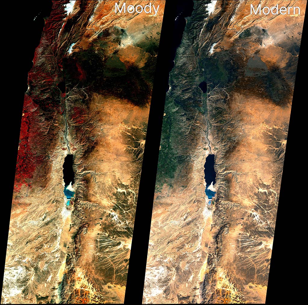
Landsat 1 didn’t include a blue sensor (Landsat satellites wouldn’t get one until Landsat 4 in 1982), which means the blue band for a natural-looking red-green-blue (RGB) output has to be derived from other bands.
Based on the above reconstruction work, I believe Moody used Band 6 (near-infrared) for red, Band 4 (green) for green, and Band 5 (red) for blue. The strong red coloring for vegetation is often a giveaway that the NIR band was used for the red channel. This kind of false-color compositing was fairly common for the era and continues today for specific purposes (like agricultural monitoring). In the print book, the Moody image crops out most of the red vegetation, which I think is a smart move for the audience.
The Moody image is relatively dark, with more contrast than we’d expect today. My recreation here is a bit bluer than the version that appears in print, but it’s the closest I could get. The print version also merges three different scenes with slightly different color processing for each. Here I was able to merge and process the three scenes together, for a more-unified look.
This “vegetation is red” look isn’t how we process satellite imagery today for general consumption, so the second image uses a combination of Bands 4, 5, and 6 to recreate a blue channel and generate a natural-looking scene that matches modern expectations. (Specifically, it does 1.2*B4 - 0.35*B5 + 0.05*B6. OpenAI’s Codex, which did these transformations for me, says, “B4 carries visible-light structure closest to what we need for a blue-like channel. Subtracting B5 suppresses warm soil response that otherwise makes blue muddy. A small B6 term can stabilize tone transitions, but too much NIR in blue quickly produces unnatural color.”) It’s not as perfect as a dedicated blue sensor would be, but it comes close.
In my opinion, the Landsat 5 image from the last post is clearer than either of these images. On the other hand, it has a blue sensor to work with. Moody worked with what they had available to them, and the 1973 image they used presents an especially clear, cloud-free view.