Mark at Biblical Studies and Technological Tools has been preparing for his BibleTech08 talk on Biblical mapping by asking his readers for their thoughts on Bible maps. Here are my responses to some of his questions.
First, I can see Bible software moving in two directions as it relates to mapping:
Outsource It: Mapping in Bible Software, Approach #1
Mapping has never been a strength of Bible software (with the possible exception of Accordance). But that’s not necessarily a problem.
Why should Bible software try to reproduce Google Earth’s features, with 3D terrain, zooming, rotating, layers, etc.? It’ll inevitably pale in comparison to Google Earth. In other words, no Bible software company is going to out-feature Google.
Rather, Bible software companies should build on existing software and innovate where they can.
Here’s what a Bible software company that wants to take this approach should do:
- License or commission attractive maps that allow minimal interactivity. I imagine that a lot of people simply want a map to print or to use in a class. Google Earth doesn’t support this task well.
- Identify place names in Bibles and reference works in their software and link these places to geocoded data. People will be able to see quickly where a location is without disrupting their immediate tasks. This kind of deep integration among resources is invaluable.
- Allow the export of this data into KML or other open formats so people who want a particular view can use Google Earth (or a similar program) to create it. They can then share these views with others.
- Release geocoding data under a Creative Commons license to allow people to reuse it. A lot of biblical regions don’t have any boundary data available on the web at the moment, for example, and it’s better to have people who know what they’re doing draw these boundaries instead of random people with lots of free time. (This last step may not be appropriate for every company.)
Integrate It: Mapping in Bible Software, Approach #2
Maybe a Bible software company really wants to add a Google Earth-style application to their program (perhaps to make sure their data stays proprietary, which I can understand). How should they do it?
They should integrate World Wind, an open-source earth viewer developed by NASA. It comes in both .NET and Java flavors. The i-cubed layer has 15-meter full-color resolution for most of the earth, which is sufficient for most purposes. It can also use Microsoft’s Virtual Earth imagery.
I think you could create a lot of interesting maps and geographic applications if you were willing to customize the World Wind interface for Bible mapping and integrate this data deeply into your software.
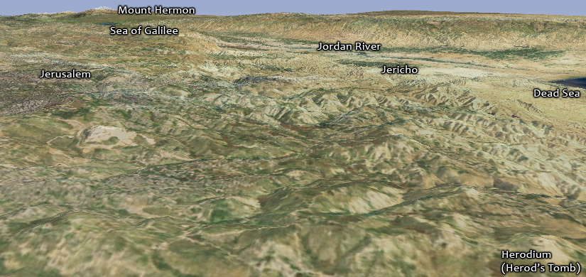
The following image, for example, from a post about Herod the Great’s tomb, uses the i-cubed imagery in World Wind:

What Makes Maps Useful?
I’m only answering for myself here, but I tend to judge a map on its aesthetics—in other words, I prefer a nice-looking map even when it’s otherwise inferior to an ugly map. A lot of Bible maps on the web just aren’t very attractive.
If two maps are equally attractive, I’ll use the one that gives me more flexibility to accomplish what I want or to increase my understanding—enabling layers or places, for example.
Finally, I don’t find static 3D cutaways (like the above image of Herod the Great’s tomb) very useful—they’re cool to look at, but the distortion in perspective makes it hard to measure distances or see how places relate to each other. However, I do find it useful to pan down in Google Earth. So I like standard overhead views for static maps but prefer dynamic maps to give me maximum flexibility.
How People Use the Maps Here
Judging from their search keywords on Google, people are looking for three main things when they come to OpenBible.info. Of course I don’t know what their ultimate aim is, but here are their immediate goals:
- An overview of Bible geography.
- The location of a specific place that they probably encountered in their Bible reading.
- Integration of Bible places and Google Earth or Google Maps.
Map Features
Here are some things I’d like to see in Bible maps in the future:
- Social integration. I don’t really know what it would involve, but a lot of mapping sites are moving to allow collaboration and sharing of maps created by users. I can imagine a lot of potential here to eliminate duplication of effort—how many people have had to create new maps just because the particular one they wanted didn’t exist? By sharing maps, the likelihood increases that someone has already created the map you want.
- Reference material about each place. If I taught a graduate or undergraduate class on Bible geography, I’d have each student write a brief summary of several places in the Bible and then release these summaries under a Creative Commons license. Then I’d integrate them into the KML files available on this site, perhaps with some links to Wikipedia or other resources for more information. In other words, I’d like to see the KML files on OpenBible contain some up-to-date scholarship on each place, so people learn more than just a place’s coordinates when they come here. It’s similar to what BibleMap.org does by including articles from the ISBE (a public-domain Bible encyclopedia). Unfortunately, all the public-domain resources show their age in terms of language and scholarship. At the very least, I’d like to link Bible places that have Wikipedia entries to their corresponding articles.
- City maps. I’d like to see city plans from various time periods. I find such maps helpful because satellite imagery can’t help you reconstruct the plans. Even better would be to geolocate the maps, so you can browse them in Google Earth and see their relation to modern cities. BibleMaps.com has about twenty biblical city maps available to buy. I’d like to see city maps implemented purely in KML as polygons, paths, and points. I’ve created a simple version of Nineveh in KML as a proof-of-concept.
- Photos. I’ve worked on aggregating some photos of Bible places, but the potential exists for a lot more. HolyLandPhotos.org has a nice, free virtual tour of selected sites (Beersheba, for example). I’d like to see this kind of approach on a larger scale—or even integrated right into Google Earth.
- Using the new terrain layer on Google maps. Satellite maps are great, but sometimes a terrain map shows things more clearly. For example:

- More Creative Commons-licensed data. Political boundary and road data are conspicuously absent from the OpenBible data set. I’ve said before that making a lot of Bible data available under open licensing will allow people to develop new views and understandings of the Bible, which in turn will let Bible software developers integrate refined versions of these advances into their products. But, again, no one should feel compelled to release work only under Creative Commons; people deserve compensation.
- International resources. This site gets a lot of visitors from people outside the U.S. They simply may not have access to the biblical resources we have here—or the ability to spend a lot of money on Bible reference materials. In any case, international interest in Bible maps is probably extensive. Maps have some internationalization issues (with place names), but not nearly to the extent that, say, Bible commentaries do.
Conclusion
Thanks to Mark for his recent roundup of the latest goings-on at OpenBible.info and for his explanation of how to find all the mentions of a place in the Bible.
I hope Mark will make the slides from his BibleTech talk available online. I look forward to seeing what he has to say.
 In Redmond, Wash., a start-up called 3D Outlook Corp. this month will begin using software from NASA to sell 3-D models of mountains and other terrain priced at under $100, says Tom Gaskins, the company’s chief executive officer. Mr. Gaskins says hikers, resorts and real-estate firms are likely customers for 3-D maps and models that show the topographic contours of ski slopes, golf courses and other landscapes.